
Perl (Moselle)
| coat of arms | Germany map | |
|---|---|---|

|
Coordinates: 49 ° 28 ' N , 6 ° 23' E |
|
| Basic data | ||
| State : | Saarland | |
| County : | Merzig-Wadern | |
| Height : | 254 m above sea level NHN | |
| Area : | 75.11 km 2 | |
| Residents: | 8581 (Dec. 31, 2019) | |
| Population density : | 114 inhabitants per km 2 | |
| Postal code : | 66706 | |
| Primaries : | 06867, 06865 (Oberleuken, Keßlingen, Münzingen), 06866 (Nennig, Sinz, Tettingen-Butzdorf, Wochern), 06868 (Büschdorf, Eft-Hellendorf) | |
| License plate : | MZG | |
| Community key : | 10 0 42 115 | |
| Address of the municipal administration: |
Trierer Strasse 28 66706 Perl |
|
| Website : | ||
| Mayor : | Ralf Uhlenbruch ( CDU ) | |
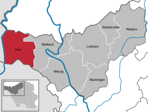
| Location of the municipality of Perl in the Merzig-Wadern district | ||
  |
||

Perl ( Moselle Franconian Pärel , Pierel , Pirel ) is a municipality in the Merzig-Wadern district in Saarland with 14 districts.
geography
location
Perl is located in the border triangle Germany - France - Luxembourg on the slopes to the right of the Upper Moselle (see also Roderborn ) and extends far up to the Moselgau . On the other side of the Moselle is Luxembourg with the villages of Schengen and Remich . The municipality of Perl is bordered to the west (Besch, Nennig and Perl) by the Moselle , which forms the border with Luxembourg here. Since the Moselle forms the Saarland part of the joint German-Luxembourgish sovereign territory over a length of around ten kilometers , which does not belong to the municipality, Perl strictly borders on this area and therefore not directly on the Luxembourgish canton of Remich on the left of the Moselle . In the south, bordering the town of Apach with Belmach and Merschweiller in France ( Lorraine ), to the north by Palzem and Kirf in Rhineland-Palatinate , in the east on the community of Mettlach in the Saarland.
The highest point in the municipality is the Schneeberg in Eft, located directly on the French border, at a height of 429 m above sea level. NHN .
Community structure

The municipality of Perl is divided into 14 districts, which are assigned to eleven municipal districts. Population as of January 1st, 2020:
| District | surface | Residents |
|---|---|---|
| Complaint | 7.82 km² | 1,493 |
| Borg | 7.98 km² | 431 |
| Büschdorf | 4.23 km² | 305 |
| Eft-Hellendorf | 9.92 km² | 309 |
| Keßlingen | 2.34 km² | 108 |
| Münzingen | 1.78 km² | 48 |
| Nennig | 9.73 km² | 1,430 |
| Upper hatches | 7.14 km² | 571 |
| Oberperl | 3.05 km² | 518 |
| Pearl | 2.96 km² | 2420 |
| Sehndorf | 2.73 km² | 240 |
| Sinz | 6.72 km² | 378 |
| Tettingen-Butzdorf | 4.77 km² | 429 |
| Weekers | 3.88 km² | 192 |
| All in all | 75.06 km² | 8,872 |
Oberleuken, Keßlingen and Münzingen as well as Tettingen-Butzdorf and Wochern each form a common district, the other districts are identical to the districts.
District Besch
With 1,493 inhabitants, Besch is the largest district after Perl. Besch (mentioned in the course of history under other names Bassius, Bessiacum, Bessich, Biske, Piche and Becha) was first mentioned in 893 as a gift to the Trier Abbey of St. Maximin. As part of the Moselsteig Trail, the Moselle promenade near Besch is very popular with cyclists and hikers.
Perl district

The district of Perl stretches from the banks of the Moselle between the vineyards up the slope. Perl is right on the border with the French Moselle department . The border town is Apach. The Gehannesbour flows into the Moselle. Immediately before the border with France is the Moselle lock Apach. On the other side of the river is the Luxembourg Schengen. There are several discount stores, shops and restaurants in Perl.
District Eft-Hellendorf
Eft-Hellendorf has 309 inhabitants. The place is in the Saargau am Schneeberg , the highest point in the municipality of Perl. The first mention of it comes from around 1130. The Leukbach , which rises in Eft, flows through the two districts of Eft and Hellendorf .
Münzingen district
Münzingen is the smallest part of the municipality of Perl. Münzingen has 43 inhabitants and is 360 m high in the Saargau on the border with Rhineland-Palatinate. The place is first mentioned in 1533. The "Greiffenklauschen Höfe zu Keßlingen and Münzingen" are mentioned in 1662. A curiosity is that Münzingen (although located in Saarland) is a church branch of the parish of Kirf (Rhineland-Palatinate).
Nennig district
Nennig has 1,430 inhabitants and is a border town with Rhineland-Palatinate and Luxembourg . Nennig is first mentioned in a document in 924, but the Roman mosaic floor and the burial mound on the outskirts prove that the place was already settled in Roman times. Two hundred meters northwest of the Roman mosaic floor is the parish church of St. Martin.
Two castles date from the Middle Ages: the Berg water castle , built in 1180 , which today houses the “Casino Schloss Berg” casino built by Saarland Sporttoto with an attached luxury hotel and restaurant; the other is Bübingen Castle, built around 1340 , which was destroyed towards the end of the Second World War and is no longer freely accessible today as a ruin.
history

Traces of settlement from the Mesolithic can be found in Perl and the surrounding area as well as grave fields from the Bronze and Iron Ages . Celtic place names and Roman buildings prove the attractiveness of the location at all times. The Roman villa in Nennig dates from the 4th century and was probably destroyed in the Battle of the Normans in 882 . Medieval castles and churches are further witnesses to an eventful past. The oldest written mentions date from the 9th century.
Until the end of the 18th century, the districts that today belong to the municipality of Perl were sovereign parts of different territories. During the so-called French era , they were subordinate to a total of three different departments . In February 1814, the places previously belonging to the Saarburg canton in the Saar department became part of the provisional Generalgouvernement Mittelrhein . After the Peace of Paris in May 1814, the four originally Luxembourgish or previously part of the Forests Department were transferred to the canton of Saarburg.
At the Congress of Vienna (1815), the canton of Saarburg was initially assigned to Austria . Finally, the three previously Lorraine towns were ceded by France at the Second Peace of Paris (1815). On July 1, 1816, the entire area that today belongs to the municipality of Perl became part of the Kingdom of Prussia .
Under the Prussian administration, all localities came to the newly created Saarburg district in the Trier administrative district , which from 1822 belonged to the Rhine province .
Overview of the previous affiliations of the districts of Perl:
Remarks:
- ↑ Nennig with Wies and Berg was a condominium that belonged jointly to the Elector of Trier and the Duke of Luxembourg.
- ↑ The village of Oberleuken was divided: on the left of the Leuk it belonged to the Electorate of Trier and on the right of the Leuk to the Duchy of Lorraine.
After the Second World War , the villages that are now part of Perl first came to the French occupation zone and were incorporated into the Saar region by the French military government in 1946 (see also: List of the municipalities affected by the connection to the Saarland in 1946 ). On June 7, 1947, he moved to the Merzig-Wadern district .
In the course of the regional and administrative reform in Saarland, the 14 previously independent municipalities became Besch, Borg, Büschdorf, Eft-Hellendorf, Kesslingen, Münzingen, Nennig, Oberleuken, Oberperl, Perl, Sehndorf, Sinz, Tettingen-Butzdorf on January 1, 1974 and Wochern the new municipality of Perl.
politics
Municipal council
| Parties | 2019 | 2014 | ||||
|---|---|---|---|---|---|---|
| proportion of | Seats | ± proportion | ± seats | proportion of | Seats | |
| CDU | 42.0% | 11 | −6.5% | −3 | 48.5% | 14th |
| SPD | 35.2% | 10 | −0.8% | ± 0 | 36.0% | 10 |
| FDP | 8.4% | 2 | +1.3% | ± 0 | 7.1% | 2 |
| FW | - | - | −3.3% | ± 0 | 3.3% | - |
| Green | 14.4% | 4th | + 9.1% | +3 | 5.3% | 1 |
| voter turnout | 56.0% | + 2% | 54.0% | |||
mayor
- 1989 - October 31, 2007: Anton Hoffmann, CDU
- November 1, 2007 - October 31, 2015: Bruno Schmitt, SPD
- from November 1, 2015: Ralf Uhlenbruch (CDU)
Election results mayoral election
Direct election of the mayor on March 4, 2007:
- Cilli Willkomm (CDU): 39.5%
- Bruno Schmitt (SPD): 60.5%
Direct election of the mayor on June 28, 2015:
- Ralf Uhlenbruch (CDU): 55.2%
- Michael Fixemer (SPD): 44.8%
Economy and Infrastructure
Perl is the only wine-growing community in the Saarland. That means: Saarland wine is only grown on the Moselle, while wine-growing on the Saar takes place in Rhineland-Palatinate, for example in Wiltingen . Perl belongs to the Mosel wine-growing region (formerly Mosel-Saar-Ruwer), Moseltor area . Bübingen Castle was set as the major location for the Perl area . Down the Moselle, the Upper Moselle area connects.
Perl was the headquarters of the drug importer Kohlpharma , the largest employer in the district. The head office has now been relocated to Merzig . Part of the company remained in Perl.
There are also many retail shops and supermarkets in the village, where many buyers from neighboring countries (mainly French and Luxembourgers) shop.
Perl-Borg is also the headquarters of Fixemer Logistics GmbH , founded in 1951 by Karl Fixemer .
traffic
Perl is connected to the national road network not only in Germany, but also to the south of the Grand Duchy of Luxembourg and Belgium via the Federal Motorway 8 . The German A 8 has been connected to the Luxembourg A 13 with the Schengen Viaduct over the Moselle since 2003 .
France is reached by road via the B 419 . The border town is Apach . The municipality is also crossed by the federal road 407 (Perl- Hermeskeil ).
The Perl train station and the stops in Besch and Nennig on the Thionville – Trier railway line are located in the Perl municipality . This route, which leads along the Moselle to Metz , was crossed exclusively by goods traffic for several years. On June 10, 2007, cross-border passenger traffic on the Upper Moselle route was put back into operation. For the time being, trains only run on weekends. This means that Perl is connected to the Metz and Thionville TGV stations .
education
Day care centers
- Day care center St. Franziskus Besch
- St. Martin Nennig day care center
- St. Quirinus Perl day care center
- Daycare center Leukbachtal Oberleuken
primary school
- Dreiländereck Perl primary school
high school
Culture and sights
Attractions
- Roman villa in Nennig with a mosaic floor
- Reconstructed Roman Villa Borg
- Roman tumulus in Nennig
- Moselle valley
- Nell Palace and Nell Park
- War cemetery Besch
Events
- annually: May 1st - Quirinus ride in Perl with blessing of horses and Perler fair (Pierler Dag)
- annually: end of October - wine and cellar festival in Perl (4 days)
- annually: in mid-August there is a fair in Merschweiller
- annually: end of August - Saarland Moselle Wine Festival in Nennig
- annually: August 15th - fair in Sehndorf
leisure
Perl is on the Moselgau loop of the Saarland circular hiking trail . The place is the starting point of the Saar-Hunsrück-Steig and the Moselsteig . The Way of St. James also runs through the municipality when coming from Trier. The "Panoramaweg Perl" is one of the few premium hiking trails on German and French territory. The "Villa Borg Trail", also a premium trail, runs around Villa Borg. In addition, the Moselle cycle path runs through the districts Nennig, Besch and Maimühle. The indoor swimming pool “PerlBad” is located in the Perl district.
Personalities
Born in Perl
- Karl Eduard Heusner (1843-1891), Vice Admiral
- Albert Grégoire (1865–1949), member of the Reichstag
- Nikolaus Simmer (1902–1986), politician (NSDAP) and Lord Mayor of Koblenz (1940–1945)
- Aloysius Winter (1931–2011), professor of theology
- Karl Peter Fixemer (* 1931), entrepreneur
- Rudolf Heinz (* 1937), philosopher, psychoanalyst and musicologist
- Edmund Kütten (* 1948), politician, member of the state parliament (since 2004)
Associated with Perl
- Christian Bau (* 1971), cook
literature
- Ernst Wackenroder : The art monuments of the Saarburg district . (= Paul Clemen (Hrsg.): Die Kunstdenkmäler der Rheinprovinz , Volume 15, III. Department). L. Schwann, Düsseldorf 1939 (reprint from the Academic Bookshop Interbook, Trier 1982), pp. 162–170.
- The municipality of Perl in the border triangle on the Moselle, Perl 2007.
Web links
- Official website of the municipality of Perl
- Literature about Perl in the Saarland Bibliography
- Link catalog about Perl at curlie.org (formerly DMOZ )
Individual evidence
- ↑ Saarland.de - Official population figures as of December 31, 2019 (PDF; 20 kB) ( help ).
- ↑ Geoplatt ( Memento of November 13, 2007 in the Internet Archive )
- ↑ Statistical overview of the municipality of Perl on www.perl-mosel.de
- ↑ Collection of the ordinances published under the Governorate of the Middle Rhine in Kreuznach , Speyer, 1819, p. 193 ( Google Books )
- ↑ Wilhelm von der Nahmer: Handbuch des Rheinischen Particular-Rechts: Development of the territorial and constitutional relations of the German states on both banks of the Rhine: from the first beginning of the French Revolution up to the most recent times . tape 3 . Sauerländer, Frankfurt am Main 1832, p. 227 ( online at Google Books ).
- ^ Wilhelm Fabricius : Explanations of the historical atlas of the Rhine province, Volume 2: The map of 1789. Bonn 1898, pp. 29, 46, 126, 127, 491, 597
- ↑ Georg Bärsch : Description of the government district of Trier: according to official sources ... , Volume 2, Lintz, 1846, pp. 92, 94, 95, 97 ( Google Books )
- ^ Federal Statistical Office (ed.): Historical municipality directory for the Federal Republic of Germany. Name, border and key number changes in municipalities, counties and administrative districts from May 27, 1970 to December 31, 1982 . W. Kohlhammer, Stuttgart / Mainz 1983, ISBN 3-17-003263-1 , p. 804 .
- ↑ Overview of the 2014 municipal council elections in Perl . Website of the Saarland statistical office. Retrieved November 14, 2014.
- ↑ City council elections 2019 in Perl on wahlresult.saarland.de. Retrieved August 5, 2019
- ↑ Daycare centers - Perl - Discover | Experience | Enjoy. Retrieved June 19, 2018 .
- ↑ a b Schools - Perl - Discover | Experience | Enjoy. Retrieved June 19, 2018 .