
Oberhasli district
| Oberhasli district | |
|---|---|
 |
|
| Basic data | |
| Country: |
|
| Canton : |
|
| Main town : | Meiringen |
| Area : | 551.37 km² |
| Residents: | 7771 (December 31, 2008) |
| Population density : | 14 inhabitants per km² |
| map | |
 |
|
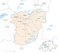
The Oberhasli district was an administrative unit of the Canton of Bern until December 31, 2009 . The administrative district with the main town Meiringen comprised six communities with 7771 inhabitants (as of December 31, 2008) on 551.37 km², the area of Haslital and Hasliberg :
Communities
| Name of the parish | Population (December 31, 2008) |
Area in km² | Inhabitants per km² |
|---|---|---|---|
| Gadmen | 248 | 116.41 | 2 |
| Guttannen | 313 | 200.85 | 2 |
| Hasliberg | 1237 | 41.74 | 30th |
| Innertkirchen | 875 | 120.20 | 7th |
| Meiringen | 4489 | 40.63 | 110 |
| Half of the shadow | 609 | 31.54 | 19th |
| Total (6) | 7771 | 551.37 | 14th |
Changes in the community
Municipalities until 2009

- 2010: District change of all 6 municipalities from the Oberhasli district → Interlaken-Oberhasli administrative district
literature
- Rudolf Jaun : Family and personal names in Oberhasli (= series of publications on local history and the history of the Hasli landscape ). Brügger, Meiringen 1981, DNB 830299548 .
- Josef Brülisauer: The legal sources of the Canton of Bern, Part Two: Rights of the Landscape, Volume 7: The Law of the Office Oberhasli (= Swiss Lawyers Association. Legal Sources Foundation [Hrsg.]: Collection of Swiss legal sources . II. Department). Sauerländer, Aarau 1984, ISBN 3-7941-2515-0 ( online ).
- Daniel Wolf, Jost von Allmen: Ernst E. Anderegg . Selected buildings in the region Interlaken-Oberhasli (= Swiss art guide. Series 89 . No. 887/888 ). Society for Swiss Art History GSK, Bern 2011, ISBN 978-3-85782-887-4 .
Web links
- Josef Brülisauer: Oberhasli (BE). In: Historical Lexicon of Switzerland .
Individual evidence
Aarberg | Aarwangen | Bern | Biel | Büren | Burgdorf | Courtelary | Erlach | Fraubrunnen | Frutigen | Interlaken | Konolfingen | Laupen | Moutier | La Neuveville | Nidau | Lower Simmental | Oberhasli | Obersimmental | Saanen | Schwarzenburg | Juicy | Signau | Tuna | Trachselwald | Cheeks
Canton of Bern | Districts of Switzerland | Municipalities of the Canton of Bern

Four parishes: Bolligen | Vechigen | Stettlen | Muri
Regional courts: Seftigen | Sternenberg | Konolfingen | Zollikofen
Offices: Thun | Zofingen | Aarau | Lenzburg | Brugg | Burgdorf | Büren | Unterseen | Wiedlisbach | Obersimmental | Lower Simmental | Frutigen | Oberhofen | Aigle | Hasli | Trachselwald | Bipp | Aarwangen | Cheeks | Landshut | Lenzburg (Office) | Schenkenberg | Aarberg | Nidau | Erlach | Laupen | Oltigen | Signau | Biberstein | Aarburg | Saanen | Brandis | Interlaken | Königsfelden | Thorberg | Fraubrunnen | Zofingen (pen) | Frienisberg | St. Johannsen | Gottstatt | Buchsee | Sumiswald | Roche (Saline) | Köniz | Kasteln | Hettiswil
Offices in Vaud: Avenches | Moudon | Yverdon | Lausanne | Morges | Nyon | Vevey | Romainmôtier | Oron | Payerne | Bonmont | Aubonne
Common lords with Freiburg: Schwarzenburg | Murten | Grandson | Echallens
Common federal dominions: Baden | Thurgau | Free offices | Rhine Valley | Sargans | Locarno | Lugano | Mendrisio | Valle Maggia
Offices and services in the city of Bern: Bauamt | Salt Directorate | Mushafen | Pen | Corn Office | Big hospital | Inselspital