
Lichtenstein / Sa.
| coat of arms | Germany map | |
|---|---|---|
.svg)
|
Coordinates: 50 ° 45 ' N , 12 ° 38' E |
|
| Basic data | ||
| State : | Saxony | |
| County : | Zwickau | |
| Management Community : | Around the Auersberg | |
| Height : | 336 m above sea level NHN | |
| Area : | 15.47 km 2 | |
| Residents: | 11,177 (Dec. 31, 2019) | |
| Population density : | 722 inhabitants per km 2 | |
| Postal code : | 09350 | |
| Area code : | 037204 | |
| License plate : | Z, GC, HOT, WDA | |
| Community key : | 14 5 24 160 | |
| City structure: | Core city; 2 districts | |
City administration address : |
Badergasse 17 09350 Lichtenstein |
|
| Website : | ||
| Mayor : | Thomas Nordheim ( Free Voters ) | |
| Location of the city of Lichtenstein in the district of Zwickau | ||
  |
||

Lichtenstein / Sa. ( Lichtenstein / Saxony ) is a small town in the district of Zwickau in Saxony . It is the seat of the administrative community around the Auersberg . Lichtenstein is nicknamed "the city in the country".
geography
Lichtenstein lies between Chemnitz approx. 29 km east and Zwickau approx. 12 km west. Lichtenstein lies north of the Western Ore Mountains at an altitude of 288 to 428 m above sea level. NN.
Neighboring communities
Neighboring communities are Bernsdorf , the city of Glauchau , St. Egidien , Mülsen as well as Hohndorf and the city of Oelsnitz / Erzgeb.
City structure
In addition to the actual urban area, the following districts belong to Lichtenstein:
- Heinrichsort (incorporation 1996)
- Rödlitz (incorporation 1994)
history


In 1212 a "castrum Lichtenstein" is mentioned for the first time in a document from King Friedrich II . The first reliable mention of the castle of Lichtenstein occurs in 1286. In 1261 the church of St. Laurentius is mentioned for the first time. The city is closely connected with the aristocratic Schönburg family. They founded Lichtenstein at the end of the 12th century, built the castle and resided here until they were expropriated in 1945. In a document from 1446, Lichtenstein is first referred to as a city. In 1627 the building of today's Ratskeller was converted into a town hall.
During the Thirty Years War , Lichtenstein was looted and burned down by imperial troops in 1632 . Seven years later, the castle was destroyed by the Swedish army and the city was plundered.
After the Thirty Years War
The Callnberg district was founded in 1708, but was only given the name Callenberg in 1712. In 1725 he received city rights. The Luther Church in the new city was built in 1770. In 1771 a city fire broke out and it took ten years to start the reconstruction of the Laurentiuskirche, which was completed in 1786. The previous Gothic building was from the 13th century, the new church received its current Jehmlich organ in 1902 . In 1771 and 1772 there was a flood disaster and a famine, as a result of which 787 people died in both cities. In 1843 the official building was built in the Schloßallee, today's Palais. The post office was built in 1859. There was another fire in the town in 1869. In the years 1877 to 1879 the Stollberg – St. Egidien , where Callnberg also has a stop. As a result of industrialization, Lichtenstein was known for its textile industry , hosiery, tricot days (underwear) and upholstery fabrics, the new district of Grünthal was founded in 1880, in which the community school was inaugurated in 1899, later the Diesterweg School. The Pestalozzi School was built in 1906 and 1907. In 1920 the cities of Lichtenstein and Callnberg united. The double name Lichtenstein-Callnberg was used by the city until April 1, 1938. Lichtenstein was initially occupied by the US Army at the end of April 1945 and then handed over to the Soviet occupiers in the summer .
GDR time
With the territorial reform in the GDR on July 25, 1952, Lichtenstein was incorporated into the newly founded Hohenstein-Ernstthal district in the Karl-Marx-Stadt district, before it belonged to the Glauchau administration . From 1956, two prefabricated building areas were built west of the train station , on the one hand the so-called Protzdorf, in which the Otto Grotewohl School, today's Heinrich von Kleist School, was opened in 1966 , and the Ernst Schneller settlement in the 1980s .
Post-turnaround time
Shortly after the political change in 1991, the foundation stone for the Am Auersberg industrial park was laid, and the Auersberg Center opened in October 2004. After the end of the GDR , Lichtenstein tried to revive tourism. In 1996 it hosted the first Saxon state horticultural show . In addition, the Mini World was opened next to the city museum in 1999, followed two years later by the Daetz Center . From 1997 to 2000 the new hospital building was built in the south of the city. In 2000, the Diocese of Dresden-Meißen sold Lichtenstein Castle, which previously housed an old people's home and the Holy Mass was held, to Prince Alexander von Schönburg-Hartenstein , and the building has been falling into disrepair ever since. The Diesterweg School was closed in 2002 and two years later the Lichtenstein Vocational School Center for Economics and Social Affairs moved into the building . In August 2003, the bypass of the B 173 was opened.
In 1994 Rödlitz and in 1996 Heinrichsort were incorporated into Lichtenstein.
Population development
Development of the population (from 1960 December 31) :


|
|
|
|
- Data source from 1998: State Statistical Office of the Free State of Saxony
1 October 29th
2 August 31st
.jpg)
politics
City council
Lichtenstein's city council consists of 22 city councilors and the mayor. The local elections on May 26, 2019 led to the following result with a turnout of 61.6%:
| Party / list | Share of votes | +/- | Seats |
| Free Voters Lichtenstein eV | 31.2% | - 6.4 | 7th |
| CDU | 24.9% | - 1.2 | 6th |
| SPD | 19.2% | - 0.9 | 4th |
| The left | 14.1% | - 0.2 | 3 |
| FDP | 10.6% | + 8.7 | 2 |
+/- change compared to the previous municipal election in 2014

mayor
List of names of the mayors of Lichtenstein, as far as they are known.
- 1566–1567: Franz Scheffler (father)
- 1567–1577: Clemens Scheffler (son)
- 1578–1592: Paul Scheffler (grandson)
- 1593–1599: Georg Wagner
- 1600–1607: Paul Schneider
- 1608–1629: Thomas Donath
- 1630–1631: Eberhard Wolf
- 1632–1632: Johann Scheffler
- 1633–1633: Wolfgang Ebert
- 1649–1649: Georg Vogel
- 1718–1726: Johann Andreas Lüdemann
- 1990–2015: Wolfgang Sedner ( CDU )
Thomas Nordheim (Free Voters) has been Mayor of Lichtenstein since August 1, 2015. He was elected in the mayoral election on June 7, 2015 with 66.3% of the valid votes and a voter turnout of 56.2% in the first ballot. His predecessor did not run for election after 25 years and Nordheim prevailed against his competitor Dagmar Hamann (CDU).
List of names of the city judges and mayors of Callnberg, as far as they are known.
- 1725–1725: Judge Jonas Pernet
- 1812–1812: City judge Zeuner
- 1813–1834: City judge Brunner
- 1834–1875: City judge / mayor Karl Friedrich Werner
- 1876–1894: Mayor Ottomar Schmidt
- 1894–1920: Mayor Max Prahtel
coat of arms
With the city union of Lichtenstein and Callnberg in 1920, the city coats of arms of both cities merged.
The old Lichtenstein coat of arms shows a gate tower in silver on a red background. The portcullis in the upper part of the archway is gold-plated. On the archway there is a tower tower that widens towards the top and consists of two floors. A dome with a gold-plated tip forms the end, flanked by two corner turrets, the tips of which are also gold-plated. On both sides of the tower there is a rose with a green stem and silver petals. The age of the coat of arms can no longer be determined precisely. As early as the middle of the 15th century, official documents bore a seal stamp with the described coat of arms.
The coat of arms of the city of Callnberg was the house coat of arms of Count Otto Wilhelm von Schönburg. He gave it to the place with the granting of town charter in 1725. The coat of arms has two strong red stripes on a silver background, leading down to the right. The spangenhelm with the corresponding count's crown is located above the shield. The decorative feathers on the helmet are also made of silver and red.
The current city coat of arms shows on the left the old Lichtenstein coat of arms with the silver gate tower on a red background. The right side refers to the earlier Callnberger coat of arms with the red stripe on a silver background. The colors red and silver correspond exactly to the Schönburg house colors.
Town twinning
- Lichtenstein has been twinned with the German town of Enger in the Herford district in North Rhine-Westphalia since 1990 . Mutual visits take place regularly at the festivities, for example the rose festival in the city of Lichtenstein and the cherry blossom festival in the city of Enger.
- There are also friendly relationships with the towns of Pfullingen in the Reutlingen district , Baden-Württemberg and Lichtenfels in Bavaria (Upper Franconia) .
Healthcare
In Lichtenstein there is a DRK hospital, a standard care hospital with 155 beds. In 1440 the first hospice was built in Lichtenstein, and in 1888 the first building took place on today's hospital grounds. The hospital cooperates closely with the DRK hospital in Chemnitz-Rabenstein , so both houses have a joint managing director. The DRK Gemeinnützige Krankenhaus GmbH Sachsen has been the sponsor since 2004; the City of Lichtenstein holds 10% of the shares in the hospital. The chief physician of the surgical-gynecological department of the Lichtenstein-Callnberg District Hospital was F. Otto Mayer, who also contributed to the anesthesia and local anesthesia.
Culture and sights

St. Laurentius Church

Mini world

Pavilion in the city forest

Lookout tower on the Alberthöhe


Youth facilities
- Self-managed youth center RIOT
theatre
- Helmnot Theater Lichtenstein
Museums
- Daetz-Centrum : interactive exhibition of masterpieces in wood
- city Museum
- Local history museum in the Gerth tower ( St. Egidien )
- Miniworld : world-famous sights in miniature format
- Mini cosmos : Germany’s most modern planetarium and 360 ° cinema
- 1. Saxon Coffee Pot Museum
music
- Musikverein Lichtenstein / Sa. e. V.
- Music publishing house Küttner
- Trombone Choir Rödlitz
- Gesangverein Lichtenstein e. V.
Buildings
- lock
- Palace palace with English garden
- St. Lawrence Church
- Luther Church
Parks
- English garden
- Käpplerschlucht
- city Park
- Bergerpark
- Alberthöhe with a 29 m high observation tower built in 1993
- Grünthal
- Schubertgrund
- Parkschlösschen
- The Lichtenstein Sculpture Trail, launched in 2009, leads along the French Park, the English Garden and continuing over the Schlosshangwiesen into the city center.
Natural monuments
- Käpplichee in the Käpplerschlucht with a chest height of 7.25 m (2016).
societies
- DRK local group "Albert Schweitzer" Lichtenstein
- Game and Sports Association Progress Lichtenstein eV
- BV Basketball Club Lichtenstein eV
- Lichtensteiner Tierlehrpfad Indianertal eV
education
Lichtenstein has a vocational school center for economics and social affairs, 2 elementary schools, 1 high school with secondary and secondary school as well as the high school Prof. Dr. Max Schneider .
traffic
After the construction of a bypass, the B 173 now passes the city. The city can be reached via 3 different runs. It can also be reached via the A 4 connection Glauchau-Ost (approx. 14 km) or Hohenstein-Ernstthal (approx. 10 km) running to the north and the A72 connection Hartenstein running south .
On the Stollberg – St. Egidien owns Lichtenstein and its Rödlitz district, in addition to the Lichtenstein (Sachs) train station, also the Lichtenstein industrial area , Lichtenstein Ernst-Schneller-Siedlung , Lichtenstein Hartensteiner Straße and Rödlitz-Hohndorf stops , which are served by the Chemnitz City Railway .

Rödlitz-Hohndorf stop (2016)

Lichtenstein Hartensteiner Strasse stop (2016)
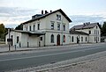
Lichtenstein (Sachs) train station

Lichtenstein stop Ernst Schneller settlement (2016)

Lichtenstein industrial area stop on the corridor of St. Egidien (2016)


.JPG)
.JPG)
.JPG)
Personalities
sons and daughters of the town
- David Sigmund Büttner (1660–1719), Protestant clergyman and early geologist and paleontologist
- Carl Christoph Rauchfuß (1725–1768), doctor, mineralogist, Africa explorer
- Christian Gottlob Richter (1745–1791), lawyer, professor at the University of Leipzig and philologist
- Gottlob Christian Crusius (1785–1848), philologist, educator and author
- Ferdinand Heinrich the Elder Ä. Listner (1826–1876), marionette puppeteer
- Paul Beckert (1856–1922), portrait and history painter
- Hugo Friedrich Colditz (1857–1933), historian, botanist
- Martin Götze (1865–1928), sculptor
- Max Wilhelm Müller (1874–1933), politician (SPD)
- Karl Max Schneider (1887–1955), professor and director of the Leipzig Zoo
- Hellmut Walter Merkel (1915–1982), founder of the Erzgebirge ensemble Aue
- Eberhardt del'Antonio (1926–1997), writer
- Edith Carstensen (1926–2018), silhouette artist, holder of the Federal Cross of Merit, 1st class
- Egon Winkelmann (1928–2015), politician (SED) and diplomat of the GDR
- Werner Buschmann (* 1931), Minister for Light Industry in the GDR
- Wolfgang Mitzinger (* 1932), Minister for Coal and Energy in the GDR
- Lothar Herzog (* 1943), former waiter and bodyguard of Erich Honecker
- Erich Rauschenbach (* 1944), cartoonist
- Richard Pietraß (* 1946), writer
- Ulrich Reimkasten (* 1953), professor of painting and textile arts
- Andreas Steiner (* 1954), politician (DSU) and former member of the People's Chamber of the GDR
- Marita Sandig (* 1958), rower, 1980 Olympic champion in eighth
- Steve Jenkner (* 1976), motorcycle racer
- Michael Sonntag (* 1978), writer and cultural scientist
- Ronny König (* 1983), soccer player
- Maximilian Kappler (* 1997), motorcycle racer
Personalities who have worked on site
- Curt Altmann (1883–1958), businessman, textile entrepreneur, from 1920 to 1945 in Lichtenstein - knitwear factory ALROWA, from 1933 ALDO knitwear factory
- Johann Avenarius (Habermann) (1516–1590), theologian, Hebraist, pastor in Lichtenstein from 1552 to 1555
- Georg Lührig (1868–1957), painter, rector of the Dresden Art Academy
- Fritz Keller (1915–1994), painter
- Klaus Hennig (* 1936), physicist
literature
- Bruno Lippmann : History of the City of Lichtenstein / Sachs. published by the City Council of Lichtenstein, 1966.
- Lichtenstein 1212-1995. Published by the Lichtenstein city administration, June 1996.
- Richard Steche : Lichtenstein . In: Descriptive representation of the older architectural and art monuments of the Kingdom of Saxony. 13. Issue: Glauchau District Authority . CC Meinhold, Dresden 1890, p. 19.
- Richard Fischer: Underground corridors in Schönburg. The underground Lichtenstein. In: Communications from the Fürstlich-Schönburg-Waldenburg Family Association, Castle Waldenburg. Issue 7, Waldenburg 1940.
- H. Colditz: War events in and around Lichtenstein. In: Schönburgische Geschichtsblätter. 1st year, Waldenburg 1894/95, p. 105.
Web links
- The official homepage of Lichtenstein
- Lichtenstein / Sa. in the digital historical directory of Saxony
Individual evidence
- ↑ Population of the Free State of Saxony by municipalities on December 31, 2019 ( help on this ).
- ↑ Statistics of the German Reich, Volume 450: Official municipality directory for the German Reich, Part I, Berlin 1939, p. 269.
- ↑ Result of the city council election 2019
- ↑ Walter Marle (Ed.): Lexicon of the entire therapy with diagnostic information. 2 volumes, 4th revised edition. Urban & Schwarzenberg, Berlin / Vienna 1935 ( list of employees ).
- ↑ Lookout tower on the Alberthöhe near Lichtenstein in Saxony on meinsachsen.net
- ^ Entry in the directory of monumental oaks . Retrieved January 10, 2017