Carreño
| Carreño municipality | ||
|---|---|---|
| coat of arms | Map of Spain | |

|
|
|
| Basic data | ||
| Autonomous Community : |
|
|
| Comarca : | Gijón | |
| Coordinates | 43 ° 10 ′ N , 6 ° 33 ′ W | |
| Height : | 873 msnm | |
| Area : | 66.75 km² | |
| Residents : | 10,337 (Jan 1, 2019) | |
| Population density : | 154.86 inhabitants / km² | |
| Postal code : | 33438 | |
| Municipality number ( INE ): | 33014 | |
| Nearest airport : | Asturias Airport 81.7 km | |
| administration | ||
| Mayor : | Manuel Ángel Riego ( PSOE ) | |
| Website : | ayto-carreno.es/es/ | |
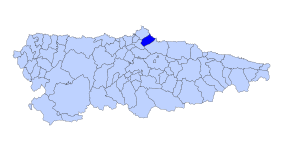
| Location of the municipality | ||

|
||
Carreño is a municipality in the autonomous region of Asturias in northern Spain.
geography
The municipality with 10,337 inhabitants (as of January 1, 2019) is one of the smaller with an area of around 67 km². The administrative seat of the municipal council is Candás.
history
As almost everywhere in Asturias, finds from the Neolithic period confirm the early settlement of the region.
Several barrows , dolmens and ramparts can still be seen today.
coat of arms
It has been used since 1866.
politics
The 17 seats of the municipal council are elected every four years and are divided as follows:
|
|
||||||||||
| Political party | 1979 | 1983 | 1987 | 1991 | 1995 | 1999 | 2003 | 2007 | 2015 | 2011 |
| PSOE | 4th | 3 | 3 | 3 | 4th | 7th | 5 | 6th | 6th | 6th |
| CD / AP / PP | 1 | 4th | 2 | 3 | 5 | 4th | 3 | 4th | 4th | 4th |
| FAC | 2 | |||||||||
| PCE / IU / IU-BA / IU-BA- Los Verdes / IU-Los Verdes | 5 | 10 | 9 | 10 | 7th | 3 | 3 | 2 | 1 | |
| BA | 1 | |||||||||
| UICA | 4th | 3 | 1 | |||||||
| CA-UN | 1 | |||||||||
| PCPE | 1 | |||||||||
| URAS | 3 | 1 | 1 | |||||||
| Somos Carreño | 4th | |||||||||
| UCD / CDS | 5 | 3 | 1 | |||||||
| CAS | 1 | |||||||||
| AA / Andecha Car | 1 | 1 | ||||||||
| Independientes | 2 | |||||||||
| Total | 17th | 17th | 17th | 17th | 17th | 17th | 17th | 17th | 17th | 17th |
economy
| Employees | Percentage | ||||
|---|---|---|---|---|---|
| TOTAL | 6,554 | 100 | |||
| Agriculture, livestock and fishing | 199 | 3.04 | |||
| Industry | 2,745 | 41.88 | |||
| Construction industry | 956 | 14.59 | |||
| Service companies | 2,654 | 40.49 | |||
| * Data from the Statistical Office for Economic Development in Asturias, status 2009 (PDF; 109 kB), SADEI | |||||
Parroquias
The Concejo Carreño is divided into twelve parroquias :
(The number in front of the name refers to the location on the overview map)
climate
According to the coastal area on the Bay of Biscay, the climate is maritime and humid with pleasantly mild summers and also mild, rarely severe winters. Due to the Picos de Europa in the hinterland, fog is to be expected in spring and autumn.
Population development

|
Nature experiences
The “wild and romantic” coast with its mixture of cliffs and bays with sandy beaches characterize the coastline as everywhere in Asturias. The mountainous hinterland invites you to go hiking in beautiful nature.
sons and daughters of the town
- Antón de Marirreguera first author of the Asturian Codex in the 17th century
- Enrique Rodríguez - bronze medalist of the 1972 Olympic Games
Attractions
Numerous centuries-old aristocratic houses and "fishermen's huts" as well as a cozy old town characterize the place. The churches are partly decorated in the Romanesque and Gothic style with “folk” paintings.
Individual evidence
- ↑ Cifras oficiales de población resultantes de la revisión del Padrón municipal a 1 de enero . Population statistics from the Instituto Nacional de Estadística (population update).
- ↑ 2011 Spanish Ministry of the Interior
- ↑ 2015 Spanish Ministry of the Interior ( Memento of the original from June 13, 2015 in the Internet Archive ) Info: The archive link has been inserted automatically and has not yet been checked. Please check the original and archive link according to the instructions and then remove this notice.
Web links
- Information about Candás and Carreño (Spanish)
- San Felix website about Candás (Spanish)


