Sariego
| Sariego municipality | ||
|---|---|---|
| coat of arms | Map of Spain | |

|
|
|
| Basic data | ||
| Autonomous Community : |
|
|
| Comarca : | Oviedo | |
| Coordinates | 43 ° 25 ′ N , 5 ° 34 ′ W | |
| Height : | 283 msnm | |
| Area : | 25.73 km² | |
| Residents : | 1,252 (Jan 1, 2019) | |
| Population density : | 48.66 inhabitants / km² | |
| Postal code : | 33518 | |
| Municipality number ( INE ): | 33065 | |
| Nearest airport : | Asturias Airport 64 Km | |
| administration | ||
| Address of the municipal administration: | Crta Vega, Km 915, 33518 Vega de Sariego, Tel .: +34 985 74 80 03 | |
| Website : | sariego.org | |
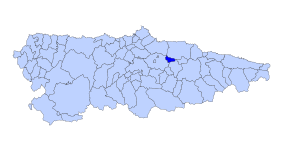
| Location of the municipality | ||

|
||
Sariego ( Asturian Sarieguu ) is a municipality ( concejo ) in the Autonomous Region of Asturias in Spain . The main town and seat of the municipal administration is La Vega .
geography
geology
The region was formed in the Triassic and Jurassic . The subsoil consists mainly of sandstone and limestone .
Waters
- The Rio Seco has its source near the village of Miares
- Cer Rio Nora has its source near San Roman
location
The municipality of Sariego is bounded by
| Northwest: Gijón | North: Villaviciosa | Northeast: Cabranes |
| West: Siero |

|
East: Nava |
| Southwest Siero | South: Bimenes | Southeast: Nava |
history
There is evidence of a settlement during the Roman occupation, but this has not yet been proven with certainty.
Sariego was first mentioned in 996 in a document in the Archdiocese of Oviedo , from which a donation from King Bermudo II and his wife Elvira to the monastery of San Pelayo in Oviedo emerges.
Persistent property disputes in the 12th and 13th centuries caused King Alfonso IX. to intervene. He appointed the independent community with its own jurisdiction and thus ended the dispute.
Jovellanos , one of the pioneers of the Enlightenment , built a pilgrims' hostel near the church of Santa María de Narzana during his exile in Asturias , which made the community an important stop on the Camino de la Costa .
In the early 19th century, the municipality was a passage area for the French army during the Spanish War of Independence . The guerrillas repeatedly inflicted bloody losses on the invading troops from the mountain slopes. During the Spanish Civil War , a small field airfield was set up in the community .
Politics
|
|
||||||||||
| Political party | 1979 | 1983 | 1987 | 1991 | 1995 | 1999 | 2003 | 2007 | 2011 | 2015 |
| PROMUSA | 7th | 5 | 6th | 6th | 6th | 5 | ||||
| FAC | 2 | |||||||||
| PSOE | 1 | 1 | 1 | 1 | 1 | 1 | 1 | 2 | ||
| PCE / IU - BA | 1 | 1 | 1 | |||||||
| CD / AP / PP | 1 | 1 | 2 | 2 | 2 | 1 | 1 | |||
| UCD / CDS | 1 | |||||||||
| URAS | 7th | 7th | ||||||||
| SD | 1 | 1 | ||||||||
| Non-party | 7th | 7th | ||||||||
| Total | 9 | 9 | 9 | 9 | 9 | 9 | 9 | 9 | 9 | 9 |
economy
| Employees | Percentage | ||||
|---|---|---|---|---|---|
| TOTAL | 412 | 100 | |||
| Agriculture, livestock and fishing | 71 | 17.23 | |||
| Industry | 75 | 18.20 | |||
| Construction industry | 52 | 12.62 | |||
| Service companies | 214 | 51.94 | |||
| * Data from the Statistical Office for Economic Development in Asturias, status 2009. (PDF; 74 kB), SADEI | |||||
Population development

Parroquias
| Surname | Asturian | Residents | Coordinates |
|---|---|---|---|
| Narcana | 397 | 43 ° 24 ′ 37 " N , 5 ° 35 ′ 17" W. | |
| San Roman | 210 | 43 ° 24 ′ 43 ″ N , 5 ° 30 ′ 30 ″ W } | |
| Santiago | 713 | 43 ° 24 '17 " N , 5 ° 32' 58" W. |
Attractions
- Parish church of Santiago el Mayor from the 10th century
- Church of Santa María de Narzana
swell
- ↑ Cifras oficiales de población resultantes de la revisión del Padrón municipal a 1 de enero . Population statistics from the Instituto Nacional de Estadística (population update).
- ↑ Election results 2011 Spanish Ministry of the Interior
- ↑ Election results 2015 Spanish Ministry of the Interior ( page no longer available , search in web archives ) Info: The link was automatically marked as defective. Please check the link according to the instructions and then remove this notice.
- Population figures see INE
- For coordinates and heights, see Google Earth
- Postcodes
Web links
- Asturian municipalities website (Spanish text)
- Pages of the municipality in the tourism portal Vivirasturias (Spanish and English text)

