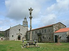
Villanueva de Oscos
| Villanueva de Oscos / Vilanova d Ozcos municipality | ||
|---|---|---|
| coat of arms | Map of Spain | |

|
|
|
| Basic data | ||
| Autonomous Community : |
|
|
| Comarca : | Eo-Navia | |
| Coordinates | 43 ° 19 ′ N , 6 ° 59 ′ W | |
| Height : | 552 msnm | |
| Area : | 72.98 km² | |
| Residents : | 292 (Jan. 1, 2019) | |
| Population density : | 4 inhabitants / km² | |
| Postal code : | 33777 | |
| Municipality number ( INE ): | 33075 | |
| Nearest airport : | Asturias airport | |
| administration | ||
| Address of the municipal administration: | La Villa s / n 33777 VILLANUEVA DE OSCOS | |
| Website : | villanuevadeoscos.es | |
| Location of the municipality | ||

|
||
Villanueva de Oscos is a municipality in the autonomous community of Asturias in northern Spain .
location
The municipality is bordered by Castropol and Vegadeo in the north, Illano in the east, Taramundi in the west and San Martín de Oscos and Santa Eulalia de Oscos in the south.
history
Finds from the Stone Age confirm the early settlement of the region. The Romans also had several forts here, traces of which can still be seen today.
The Camino de Santiago
The Cistercian monastery (Monasterio de Santa María de Villanueva) is a stop on the Way of St. James , the Camino del Norte.
Transport links
From Vegadeo direction (20 km) direction Los Oscos on the AS-11, exit Garganta, follow the AS-13. Oviedo airport , 185 km and Rozas .
Natural conditions
The subsoil, consisting mainly of limestone and sandstone , with the O Filso (1,202 m) as the highest elevation, is typical of this wooded region close to the coast. The Rio Vilanova , a tributary of the Rio Suaron .
As in large parts of Asturias, the proximity to the Gulf Stream means that the climate here is almost Mediterranean, with warm, dry summers but cold winters, and in autumn there are sometimes relatively strong storms.
politics
| Historical development in the municipal council of Villanueva de Oscos | ||||||||||
| Political party | 1979 | 1983 | 1987 | 1991 | 1995 | 1999 | 2003 | 2007 | 2011 | 2011 |
| PSOE | 1 | 1 | 4th | 4th | 5 | 5 | 4th | 5 | 6th | 6th |
| CD / AP / PP | 1 | 2 | 2 | 1 | 3 | 2 | 1 | 1 | ||
| UCD / CDS | 6th | 1 | 3 | |||||||
| JIU | 1 | |||||||||
| URAS | 1 | |||||||||
| Non-party | 5 | |||||||||
| Total | 7th | 7th | 9 | 7th | 7th | 7th | 7th | 7th | 7th | 7th |
|---|---|---|---|---|---|---|---|---|---|---|
economy

As in large parts of Asturias, agriculture has been the largest livelihood here since time immemorial, as evidenced by the many old Hórreos . The proximity to the Ria del Eo and the wooded area allow the tourism industry to grow rapidly. Trade and production takes place only in small and medium-sized companies. Many farmers have focused on the production of cider apples for the Asturian Sidra specializes what here a " national drink is". Two cattle markets are also held here:
- Feria de Ganado in La Bobia, May 30th
- Annual Feria de Ganado in La Garganta July 26th and September 29th
| Employees | Percentage | ||||
|---|---|---|---|---|---|
| TOTAL | 115 | 100 | |||
| Agriculture, livestock and fishing | 51 | 44.35 | |||
| Industry | 0 | 0.00 | |||
| Construction industry | 16 | 13.91 | |||
| Service companies | 48 | 41.74 | |||
| * Data from the Statistical Office for Economic Development in Asturias , status 2009 (PDF; 75 kB), SADEI | |||||
Population development of the municipality

Attractions
- Cistercian monastery ( Monasterio de Santa María de Villanueva ) from 1203 (repealed 1835) 43 ° 18 ′ 37.8 ″ N , 6 ° 58 ′ 52 ″ W.
- Casa de Guzmán and Iglesia (church) in Martul
Festivals and Celebrations
- Feria de Santa Ana, July 26th in La Garganta
- San Antonio, 2nd weekend in August, in Bustapena
- Santa María, 1st Sunday of September, en Villanueva
- San Juan Degollado in Martul
structure
The parish is divided into four parroquias.
- San José Gestoso 106 inhabitants (2006)
- Martul 31 inhabitants (2006)
- San Cristóbal 27 inhabitants (2006)
- Villanueva 66 inhabitants (2006)
(Source: INE )
The following hamlets and villages belong to the municipality: Salgueiras, Gestoso (Xestoso), Martul Regodeseves (Regodesebes), Villar Pasarón, Batribán, Cotarelo, Morán, As Toleiras, Cimadevila, Salcedo, Sanamede, Trabadelo, A Bovia, Busdemouros, Eleyequete., Moureyequete , San Cristobal (San Cristobo) and A Sela de Murias. (Source: INE )
Individual evidence
- ↑ Cifras oficiales de población resultantes de la revisión del Padrón municipal a 1 de enero . Population statistics from the Instituto Nacional de Estadística (population update).
- ^ Election results 2011 Spanish Ministry of the Interior
- ↑ Election results 2015 Spanish Ministry of the Interior ( Memento of the original from July 3, 2015 in the Internet Archive ) Info: The archive link was inserted automatically and has not yet been checked. Please check the original and archive link according to the instructions and then remove this notice.
- Population figures see INE
- Postcodes on Ingeniuz.com
- For coordinates and heights, see Google Earth
Web links
- Federación Asturiana de Concejos
- Guía del Occidente. Villanueva de Oscos
- Info page
- Side of the Cistercians
- Villanueva de Oscos. domusnatura.com, accessed October 31, 2010 (Spanish).
- Weather forecast


