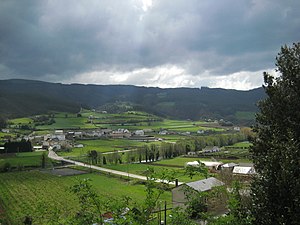
San Tirso de Abres
| San Tirso de Abres municipality | ||
|---|---|---|
| coat of arms | Map of Spain | |

|
|
|
| Basic data | ||
| Autonomous Community : |
|
|
| Comarca : | Eo-Navia | |
| Coordinates | 43 ° 25 ′ N , 7 ° 9 ′ W | |
| Height : | 38 msnm | |
| Area : | 31.42 km² | |
| Residents : | 410 (Jan. 1, 2019) | |
| Population density : | 13.05 inhabitants / km² | |
| Postal code : | 33774 | |
| Municipality number ( INE ): | 33063 | |
| Nearest airport : | Asturias airport 113 km | |
| administration | ||
| Address of the municipal administration: | Calle del General Aranda, 33774 Llano (El), Tel .: +34 985 47 64 07 | |
| Website : | santirsodeabres.es | |
| Location of the municipality | ||

|
||
San Tirso de Abres (Santiso d'Abres) is a municipality in the Autonomous Community of Asturias , in northern Spain with the municipal capital El Llano .
location
The municipality is bounded by Taramundi and Vegadeo to the east, north, west and south of Lugo .
history
Finds from the Stone Age confirm the early settlement of the region. In the neighboring communities still bear witness cairns and several hill forts from the settlement by gallaeci and Asturians . The Romans also had a small fort here, but nothing is visible anymore.
geology
land
The subsoil, consisting mainly of limestone and slate , with the Xunqueira (664 m) as the highest elevation, is typical for the region.
Waters
The municipality is crossed by the Río Eo .
climate
As in large parts of Asturias, the proximity to the Gulf Stream means that the climate here is almost Mediterranean, with warm, dry summers but cold winters, and in autumn there are sometimes relatively strong storms.
economy
As in much of Asturias, agriculture is the main industry here. Trade and production only take place in medium-sized companies.
| Employees | Percentage | ||||
|---|---|---|---|---|---|
| TOTAL | 136 | 100 | |||
| Agriculture, livestock and fishing | 61 | 44.85 | |||
| Industry | 8th | 5.88 | |||
| Construction industry | 9 | 6.62 | |||
| Service companies | 58 | 42.65 | |||
| * Data from the Statistical Office for Economic Development in Asturias, status 2009 (PDF; 105 kB), SADEI | |||||
politics
|
|
||||||||||
| Political party | 1979 | 1983 | 1987 | 1991 | 1995 | 1999 | 2003 | 2007 | 2011 | 2015 |
| CD / AP / PP | 3 | 3 | 4th | 4th | 5 | 4th | ||||
| PSOE | 5 | 6th | 6th | 7th | 4th | 4th | 3 | 3 | 1 | 3 |
| PCE / IU - BA | 1 | |||||||||
| UCD / CDS | 4th | 1 | 1 | |||||||
| Total | 9 | 7th | 7th | 7th | 7th | 7th | 7th | 7th | 7th | 7th |
Population development of the municipality

Attractions
- Castro Wallenburg Mourela Croas.
- Monasterios (monasteries), Iglesias (churches) and Capillas (chapels) in San Juan, El Llano / San Salvador and El Llano.
Festivals and Celebrations
- El Llano - San Isidro Labrador (May)
- San Juan Bautista (June)
Parroquias
The community is also the Parroquia.
- San Tirso De Abres, San Salvador (parroquia)
(Source: INE )
Hamlets and villages
- El Llano 125 inhabitants 2006
- Salcido
- Louredal
- Castro Mourela
- Grandela
- Espasande
- Villar
- Lourido
- Valiñaseca
swell
- ↑ Cifras oficiales de población resultantes de la revisión del Padrón municipal a 1 de enero . Population statistics from the Instituto Nacional de Estadística (population update).
- ^ Election results 2011 Spanish Ministry of the Interior
- ↑ Election results 2015 Spanish Ministry of the Interior ( Memento of the original from July 1, 2015 in the Internet Archive ) Info: The archive link was inserted automatically and has not yet been checked. Please check the original and archive link according to the instructions and then remove this notice.
- Population figures see INE
- Postcodes [1]
- Height information Google Earth


