Collalto Sabino
| Collalto Sabino | ||
|---|---|---|

|
|
|
| Country | Italy | |
| region | Lazio | |
| province | Rieti (RI) | |
| Coordinates | 42 ° 8 ' N , 13 ° 3' E | |
| height | 980 m slm | |
| surface | 22 km² | |
| Residents | 398 (Dec. 31, 2019) | |
| Population density | 18 inhabitants / km² | |
| Post Code | 02022 | |
| prefix | 0765 | |
| ISTAT number | 057018 | |
| Popular name | Collaltesi | |
| Patron saint | San Gregorio Magno | |
| Website | Collalto Sabino | |
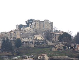
 Panorama from Collalto Sabino |
||
Collalto Sabino is an Italian commune in the province of Rieti in the Lazio region with 398 inhabitants (as of December 31, 2019). It is located 73 km northeast of Rome and 46 km southeast of Rieti .
geography
Collalto Sabino is located above Lake Turano and the Turano Valley . It is located below Monte Navegna in the Sabine Mountains . A large part of the municipality is part of the Monti Navegna e Cervia nature reserve . The districts are Ricetto and San Lorenzo.
The neighboring towns are Carsoli ( AQ ), Collegiove , Marcetelli , Nespolo , Pescorocchiano , Turania .
Collalto Sabino is a member of the Comunità Montana del Turano and the association I borghi più belli d'Italia (The Most Beautiful Places in Italy).
history
In the 10th century the Turano valley was devastated by the Saracens . Presumably surviving residents founded Collalto on a ledge, which first appeared in documents as Collis Altus at this time .
In 1335, Collalto became a principality that successively belonged to the noble families Savelli, Strozzi and Soderini before becoming part of the Barberini in 1641 .
Population development
| year | 1861 | 1881 | 1901 | 1921 | 1936 | 1951 | 1971 | 1991 | 2001 | 2011 |
|---|---|---|---|---|---|---|---|---|---|---|
| Residents | 1,520 | 1,429 | 1,601 | 1,607 | 1,337 | 1,222 | 810 | 539 | 497 | 440 |
Source ISTAT
politics
Maria Pia Mercuri (list of citizens) was elected mayor in June 2016. Your list of citizens also includes 7 of the 10 local councils. Her predecessor Cesare D'Eliseo was no longer a candidate.
Partner municipality
Attractions
- The mighty Castello Baronale was founded in the 12th century.
- In the medieval village there are still houses from the 12th century around the Piazza della Podesteria.
- Nearby are the ruins of the Castello di Montagliano, which was destroyed in the 15th century.
Daughters and sons of the church
- Carlo Murena (1713–1764), architect
literature
- Christoph Henning: Lazio. The land around Rome. With walks in the Eternal City (= DuMont art travel guide ). 3rd updated edition. DuMont-Reiseverlag, Ostfildern 2006, ISBN 3-7701-6031-2 .
Web links
- Blog about Collalto Sabino (Italian)
- Collalto Sabino on www.sabina.it (Italian)
- Collalto Sabino on www.comuni-italiani.it (Italian)
Individual evidence
- ↑ Statistiche demografiche ISTAT. Monthly population statistics of the Istituto Nazionale di Statistica , as of December 31 of 2019.
- ^ I borghi più belli d'Italia. Borghipiubelliditalia.it, accessed August 31, 2017 (Italian).
- ↑ Statistiche demografiche ISTAT . Population statistics from the Istituto Nazionale di Statistica, as of December 31, 2011.
- ↑ La Repubblica , June 6, 2016, accessed September 23, 2016

