
Darmstadt Castle (Groß-Umstadt)
| Darmstadt Castle (Groß-Umstadt) | ||
|---|---|---|
![The castle in a drawing from 1655 [1] from the Topographia Hassiae by Matthäus Merian published in the Topographia Germaniae. View from the south-east of Herrnberg to the north over the eastern part of the city [2]](https://de.wikipedia.org/wiki/Datei:Merian-Umbstatt-1655_Hanauisches-Schloss-Ausschnitt.png) The castle in a drawing from 1655 from the Topographia Hassiae by Matthäus Merian published in the Topographia Germaniae . View from the southeast of Herrnberg to the north over the eastern part of the city |
||
| Alternative name (s): | Hanau Castle, Lower Castle | |
| Creation time : | Moated castle before 1350 City palace 1727–1747 |
|
| Castle type : | Former Moated castle, converted into a city palace from the 18th century | |
| Conservation status: | Two-winged right-angled lock remains | |
| Standing position : | Castle residence formerly Hanau, later Darmstadt | |
| Construction: | Sandstone masonry | |
| Place: | Groß-Umstadt | |
| Geographical location | 49 ° 52 '10 " N , 8 ° 55' 46.7" E | |
| Height: | 162 m above sea level NN | |
|
||

The Darmstadt Castle (also called Hanauer Castle or Lower Castle ) is located in the northeast of the city of Groß-Umstadt in the Darmstadt-Dieburg district in Hesse and is an aristocratic seat that emerged from a former moated castle , which was expanded into a residential palace in the late Middle Ages . It is one of the former seven noble residences of the city.
location


In the Middle Ages, the castle was a security lock for the eastern access to the city via Pferdsbach (also called Mühlbach here ) and the city moat with a direct location on the city wall . Today it marks the eastern entrance to the old town next to the town hall.
history
The former castle was built as early as the 12th century by order of the Fulda monastery , the owner of the city of Umstadt ( Omestat majoris ). The castle served as the official residence of the Fulda bailiffs and later fiefdoms, the County of Katzenelnbogen and the Munzenberg family, who already managed to acquire the castle as an allodial property . Umstadt was administered as a condominium . The fief of Münzenberger was after their extinction in the male line in 1255 by the Hanauern taken: An inheritance fell to Reinhard I of Hanau , who as Tochtermann with Adelheid von Münzenberg was married ( Münzenberger inheritance ). The Katzenelnbogen rule was ousted.
In 1374 the monastery also pledged the other half of the city to Hanau, but in 1390 sold the entire city to the Palatinate . Hanau receives half of it as a fiefdom of the Electorate of Palatinate instead of a Fulda fiefdom. It only becomes legally binding in 1427, after the Palatinate finally paid the purchase price. In 1376 it was first mentioned (on the occasion of disputes with the Wertheim house ) as a moated castle . From here the people of Hanau ruled their half of the city.
In 1458 Anna von Lichtenberg and Philipp I the Elder “consummated” their marriage in the castle. It can be assumed that the Umstädter fiefdom is now also assigned to the County of Hanau-Lichtenberg . The castle was rebuilt and expanded in the Gothic style from 1460 .
Until 1504 it is from the Hanauer under Philipp III. inhabited by Hanau-Lichtenberg . In the Bavarian feud from 1504 to 1521, the town and castle were conquered by the Hessian Landgrave Wilhelm II and, after a settlement, finally went to the Landgraviate of Hesse under Philip I, Philip III in 1524 . von Hanau-Lichtenberg is settled with a payment of 16,000 Fl in 1521 and the rule over the ten villages Langstadt and Kleestadt . The castle becomes the official seat of the Hessian landgraves.
Until 1530 Johann von Löwenstein was a pawnbroker in Umstadt. Landgrave Philipp von Hessen was only able to find a new pawnbroker in Otto von Boineburg zu Felsberg and Gerstungen in 1538 .
In the middle of the 18th century the castle was completely rebuilt as a baroque palace. After 1787, it still housed the official registry and registry .
Building history


Built as a moated castle, more precise construction dates are only handed down with the copper engraving by Matthäus Merian around 1645. At that time the castle consisted of a high and mighty four-story defense tower that was built directly onto the city wall. It was occupied by four small two-story corner towers and had a tapering roof, with a dormer on each side . The tower was flanked by a house with a stepped gable on both sides. The (northwest) smaller tower behind it (only the height of the house) was the gate tower to the city wall and to the castle entrance. In 1640 the still existing keep or residential tower ( Palas ) was demolished due to its dilapidation. It goes without saying that the farm buildings exist.
From 1727 to 1747 the former castle was completely redesigned and converted into a baroque three-wing complex. None of the old buildings have been preserved. To the north, the complex ends with the city wall, which can now be seen much lower and, with small interruptions, still around seventy meters long. The basement of the north wing facing the street Am Darmstädter Schloss to the east (looking towards the town hall ) used to be a direct part of the city wall.
How the castle was rebuilt can be seen on the floor plan of the geometer Balthasar Blum from 1787: the tower and palas from the time it was built no longer exist (see Merian picture). It can no longer be verified whether the clerk's building, which is now in its place, is remodeled or newly built. Official secretary was also demolished in the 20th century. The two-winged courtyard gate to the west led to the large inner courtyard, the " Vordersten Hofblatz including the dung leaf " (B). To the north was the west wing (building IV), the so-called wine press house . This also contained the bailiff's apartment. The baroque garden (A) based on the French model was framed even further north by part of the city wall. It could only be entered via the forecourt (D). which was also the entrance to the other castle wings. The administrative office (building II) separated the garden and forecourt from each other. Next to it was the two-storey wash house (Building III), which was built directly onto the northern city wall. The north and south wings (Building I) were grouped around the forecourt as a rectangular ensemble. To the south in front of it was the vegetable garden as part of the large inner courtyard. The stables (building V) and the tithe barn (building VI) with two small pigsties in front of them (*) were located on the eastern city wall . To the south of the large inner courtyard was the two-storey fruit store, called the Long House (Building VII). The structure and purpose of Buildings VIII to X are not known, but were probably used for supply or residential purposes for the servants . The courtyard gate was framed to the south by the large pigsty . All roofs were marked as hip roofs . The wide longitudinal buildings, the south wing and the long house determined the overall impression.
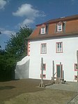
Since the middle of the 20th century there are only restored north and south wings with passage. Both are united under a mansard roof . The north wing has one storey on a high plinth, while the south wing has two storeys. The third wing, which in turn connected vertically to the west wing and gave the entire ensemble an S-shaped floor plan, was demolished in 1952. In its place today stands the memorial with a menorah in memory of the old synagogue and behind it the stele with the list of all (Greater) Umstadt Jews who fell victim to the Holocaust between 1933 and 1945. Only parts of the former forecourt are now part of the palace ensemble. The garden became part of the old people's and senior citizens' foundation located on it today.
The castle was extensively restored in 1974 and made state property.
- Castle impressions

Still standing north (left) and south wing with a view of the inner courtyard. The green wall is a remnant of the city wall.
Inner courtyard and north wing with remnants of the city wall

The east side of the north wing of the castle. The lower part used to be part of the city wall (up to the heel).

Remnants of the city wall on the northwestern passage with a view of the south wing and inner courtyard (lower today)


Todays use
The castle was owned by the state of Hesse , which transferred it to the Evangelical Church in Hesse and Nassau for use. The Evangelical Deanery of Vorderer Odenwald is located in the south wing with the dean and the dean's youth office. The Ecumenical Hospice Association Groß-Umstadt and the Groß-Umstadt branch of the Diakonisches Werk Darmstadt-Dieburg are also located there. Radio Weinwelle now broadcasts annually from the rooms in the south wing to the Groß-Umstadt wine festival .
The castle was sold around 2010 and is in private hands. It has been extensively renovated and restored in recent years. The inner courtyard bordered by the palace wing was restored in an exemplary manner. The usage contracts with EKHN will be continued.
literature
- Max Herchenröder : The art monuments in Hessen, district of Dieburg. Darmstadt, 1940, p. 129 ff.
- Siegfried RCT Enders: Darmstadt-Dieburg district (monument topography of the Federal Republic of Germany - cultural monuments in Hesse). Braunschweig / Wiesbaden 1988.
- G. Brenner - a resident and his city. Essays on history. Publication series Autmundisstat, special volume, published by Museums- und Geschichtsverein Groß-Umstadt , 2009, 1st edition.
- W. Schröck-Schmidt: Darmstadt Castle. In: Magistrat der Stadt (ed.): 1250 years Groß-Umstadt 743–1993. Geiger-Verlag, Horb am Neckar, ISBN 3-89264-771-2 , p. 188 f.
- Rudolf Knappe: Medieval castles in Hessen. 800 castles, castle ruins and fortifications. 3. Edition. Wartberg-Verlag, Gudensberg-Gleichen 2000, ISBN 3-86134-228-6 .
- Rolf Müller (Ed.): Palaces, castles, old walls. Published by the Hessendienst der Staatskanzlei, Wiesbaden 1990, ISBN 3-89214-017-0 .
Web links
- The old floor plan according to Max Herchenröder (The art monuments in Hesse. Dieburg district), Darmstadt 1940, p. 134: in Hesse's regional historical information system
Individual evidence
- ↑ Since the tower was torn down around 1640 and the Thirty Years' War had wreaked havoc, it is very likely that the engraving must have been drawn before 1620.
- ↑ The " Diepurg " drawn in on the horizon is either incorrect or the hilly landscape drawn to the right of it is incorrect, because in this direction you can only see the flat forest between Groß-Umstadt and Dieburg.
- ↑ Served to differentiate the Palatinate Castle , which was also called the Upper Castle .
- ^ After Max Herchenröder : The art monuments in Hessen. District of Dieburg. Darmstadt 1940.
- ^ A b Christoph Rommel History of Hesse. Third part, first department, Kassel 1827, self-published, p. 155 ( books.google.com ).
- ↑ The still existing keep of Nassau Castle is very suitable for structural comparisons .
- ↑ State Archives Darmstadt, File No. E 14A, conv. 97/4 also in P. Füßler: The Darmstädter Schloss 200 years ago. In: The Odenwälder Bote. Groß-Umstadt, January 5, 1988.
- ↑ In 1938 the synagogue was desecrated and finally demolished in 1978 against the will of the local council and district council and taken to the Hessenpark . Pictures under Groß-Umstadt in the 19th and 20th centuries .

Albini Castle | Alsbach Castle | Old castle | Old castle jme broich | Old castle | Babenhausen Castle | Bickenbach Hunting Lodge | Braunshardt Castle | Curti lock | Darmstadt Castle (Groß-Umstadt) | Dieburg Castle | Dorndiel Castle | Ernsthofen Castle | Fechenbach Castle | Frankenstein Castle | Gans'scher Adelshof | Graefenhausen Castle | Habitzheim Castle | Old hunting lodge Harreshausen | Heddersdorf'scher Adelshof | Heiligenberg Castle | Jossa Castle | Castle Klein -zimmer | Lichtenberg Castle | Nieder-Modau Castle | Wasserburg Schloss-Naus | Veste Otzberg | Palatinate Castle | Rodenstein Castle | Schaafheim Castle | Schlierbach Castle | Castle Ober-Beerbach | Seeheim Castle | Stockau Castle | Tannenberg Castle | Wambolt's Castle | Hamlet hill | Wellberg Castle


Amorbach Palace | Alsbach Castle | Old castle | Old castle | Auerbach Castle | Bacheburg | Bad König Castle | Beerfurther Schlösschen | Birkenau Castle | Palais Boisserée | Breuberg Castle | Ringwall Bürgstadter Berg | Burgschell | Jagdschlösschen Carlsruhe | Curti lock | Dallau Castle | Darmstadt Castle (Groß-Umstadt) | Dauchstein Castle | Mountain fortress Dilsberg | Dorndiel Castle | Emichsburg | Eberbach Castle | Erbach Castle | Erdwerk Ohrbacher Schanze | Ernsthofen Castle | Eulbach Hunting Lodge | Fechenbach Castle | Frankenberg Castle (Amorbach) | Frankenstein Castle | Freienstein Castle | Freudenberg Castle | Fürstenau Castle | State Park Princely Camp | Fürstenstein Castle | Gammelsbach Hunting Lodge | Ringwall Greinberg | Burgstall Güttersbach | Guttenberg Castle | Grand Ducal Palace (Heidelberg) | Hammer lock | Hardheim Castle | Harfenburg | House to the Giant | Heddersdorf'scher Adelshof | Heidelberg Castle | Heiligenberg Castle | Heppenheim City Palace | Hinterburg | Hirschburg | Hirschhorn Castle | Hochhausen Castle | Hornberg Castle | Hundheim Castle | Jossa Castle | Kirchbrombach Castle | Jagdschloss Krähberg | Kronenburg | Kurmainzer Amtshof | Landsehr Castle | Lichtenberg Castle | Limbach Castle | Lindenfels Castle | Lohrbach Castle | Löwenstein Castle | Lützelbach Castle | Wall hexagon | Max-Wilhelmshöhe hunting lodge | Michelstadt Castle | Mildenburg | Minneburg | Mittelburg | Burgstall Mörlenbach | Palais Morass | Mühlhäuser Schlößchen | Neuburg Castle (Baden) | Nieder-Modau Castle | Upper Heidelberg Castle | Obrigheim Castle | Ohrsberg Castle | Veste Otzberg | Palatinate Castle | Reichenberg Castle | Reichenstein Castle | Riedern moated castle | Rodenstein Castle | Rodenstein Castle | Rohrbach Castle | Rohrbach Castle | Schaafheim Castle | Schanzenköpfle | Schauenburg | Schlierbach Castle | Castle Ober-Beerbach | Schloss-Naus castle | Schneirersbuckel tower hill | Schnellerts Castle | Schönberg Palace | Swallow's Nest | Schwarzach moated castle | Schweinberg Castle | Starkenburg | Stolzeneck Castle | Strahlenburg | Stutz Castle | Amorbach Templar House | Tannenberg Castle | Lower Hardheim Castle | Vorderburg | Wachenburg | Burgstall Waldau | Waldeck Castle | Waldleiningen Castle | Wald-Michelbach Castle | Wambolt's Castle | Hamlet hill | Weinheim Castle | Wiser Castle | Wildenberg Castle | Windeck Castle | Wörth Castle (Wörth am Main) | Zwingenberg Castle