
Central Russia
| Central Federal District | |
|---|---|
  |
|
| Area : | 650,205 km² |
| Residents : | 37,127,000 (2009) |
| Population density : | 57 inhabitants / km² |
| Administrative headquarters : | Moscow |
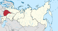
Central Russia is the name of a historical landscape and an administrative unit in Russia (see Federal structure of Russia ). The Central Federal District was created by decree of the Russian President on May 13, 2000. The federal district itself comprises 18 federal subjects . Central Russia covers an area of 650,205 km². The administrative center of the district is the city of Moscow .
geography

The region (" Central Federal District", Russian Центральный федеральный округ , Zentralny federalny okrug ) lies on the western border of today's Russia. Central Russia has no natural borders, so the area is 600 to 800 kilometers from the nearest sea, the closest seas are the eastern part of the Baltic Sea , the Sea of Azov and the White Sea . The Central Federal District borders on Belarus to the west and Ukraine to the southwest. There are also internal Russian borders in the south to the Federal District of Southern Russia , in the east to the Federal District of Volga and in the north to the Federal District of Northwestern Russia .
Central Russia lies in the Eastern European lowlands , subdivided into landscapes such as B. the Valdai Heights , the Moscow Ridge , the Smolensk Heights , the Central Russian Plate and the Oka-Don Plain . High mountains are completely absent. The highest point in the federal district is the Popowa Gora in the Waldai heights at 351 meters. The largest rivers of the overall very water-rich area are (tributaries in brackets): the Volga ( Oka ), Don ( Voronezh ), Dnepr ( Desna , Seim ) and the Düna .
.jpg)
In terms of nature, different vegetation zones form from north to south , starting with the taiga in the north, the mixed forest zone , the deciduous forest zone and the forest steppe in the south . About 40 percent of the Moscow Oblast is forested. The length of the growing season is 175 days in the north to 185 days in the south. The amount of precipitation ranges from 420 mm per year in the southeast to 600 mm per year in the north. The conditions for agriculture are favorable in the entire district. About 19 percent of the total arable land in Russia is in the area of central Russia. The soils in the north are poor podsols ( spodosols ). In the south, more nutrient-rich gray forest soils ( alfisols ) and Chernozemb soils predominate . The climate is temperate continental . The average temperature ranges from –7 to –14 ° C in January and from 16 to 22 ° C in July. Summers are generally warm and humid.
In terms of mineral resources, a total of 60% of the Russian iron ore deposits ( Kursk magnetic anomaly ), phosphates (25% of the Russian deposits), bauxite (15% of the Russian deposits), lignite , cement raw materials (25% of the Russian deposits) and peat can be found on the territory .
history
.jpg)
Historically, Central Russia formed the nucleus of the country, from which the further territorial expansion and Russian history mainly developed (see also Golden Ring ). Until the October Revolution of 1917, the region formed the central part of the country, since until then Asiatic Russia was not an integral part of the motherland, but a colony , while Belarus , the Baltic States and Ukraine were still counted as Russia.
From the 7th to the 12th century the area was settled by East Slavic and Finno-Ugric tribes (e.g. Kriwitschen , Vjatitschen ). Since the end of the 10th century the area belonged to the Kievan Rus . From this point on, combined with the increasing fragmentation of the Kievan Rus as a result of the unfavorable seniority principle , several sub-principalities were formed in the area of central Russia such as the Principality of Vladimir , the Principality of Ryazan , the Principality of Moscow , the Principality of Smolensk and others.
After the Mongolian invasion of Rus in 1240, the Grand Duchy of Moscow became dominant over the long term from 1300 onwards, and it succeeded in incorporating the neighboring principalities into its domain ( paternal inheritance ). This process was completed by around 1500. From then on, the entire Russian country, including its newly annexed areas beyond central Russia, was ruled from Moscow. The southern parts of today's federal district (Belgorod, Voronezh) came under Russian control in the 16th century, after the destruction of the khanates Kazan , Astrakhan and the Nogai Horde . However, these areas remained threatened by incursions by the Crimean Tatars for a long time, so strong fortifications were built here for protection.
The administrative predecessor unit for Central Russia was the Moscow Governorate , which was founded by Peter I in 1708, was territorially changed several times and existed until 1929.
During the Second World War , from 1941 to 1943, some of the greatest battles, such as the Battle of Moscow or the Battle of Kursk, took place on the territory of what is now central Russia . To date, unexploded mines and bombs have been found in the region's forests.
Population and cities

With just over 37 million people, Central Russia is the most populous district in the Russian Federation. About a quarter of the total population of Russia live here. At the same time, the district is most densely populated compared to the seven other federal districts and about seven times as densely populated as the national average. Ethnically, the Russian population forms the dominant proportion with 91.32% (2002). In the northeast there are some Urural minorities like the Mordvins and Mari . Central Russia is also the only federal district in which there are no separate national (sub) republics. The proportion of the rural population is around 20 percent. The federal district is very unevenly populated. About half of the total population lives in Moscow and the surrounding area. The greatest concentration of the population is in the east and south of Moscow.
The twelve largest cities within the federal district (as of 2014):
- Moscow (12,197,596 inhabitants), center of the region and capital of the country, largest city in Europe
- Voronezh (1,023,570 inhabitants), the largest city in the Black Earth region in the south of the federal district, the center of aircraft production
- Yaroslavl (603,961 inhabitants), important industrial location, old Russian city on the Volga, part of the Golden Ring
- Ryazan (532,772 inhabitants), industrial city, former seat of a principality with a Kremlin
- Lipetsk (510152) Center of iron ore mining area with steel mills, machine building and chemical industry
- Tula (487,841 inhabitants), city south of Moscow, famous for its production of weapons, samovars and gingerbread
- Kursk (431,171 inhabitants), important industrial city, center of a large iron ore deposit, the Kursk Magnetic Anomaly , in the south of the federal district
- Tver (413,960 inhabitants), city on the Upper Volga, former center of the Grand Duchy of Tver and Moscow's most stubborn competitor in the struggle for supremacy in Russia, today an important industrial center and transport hub
- Ivanovo (409,285 inhabitants), formerly an important trading city and center of the textile industry northeast of Moscow
- Bryansk (408,472 inhabitants), an important industrial location southwest of Moscow
- Belgorod (384,425 inhabitants), economic and administrative center of the oblast of the same name on the border with Ukraine and seat of an archbishopric
- Vladimir (352,681 inhabitants), former capital of the Grand Duchy of Vladimir-Suzdal, center of culture and power before the Mongol invasion of the Rus, temporarily seat of the Metropolitan of the Russian Orthodox Church
economy
The economy of Central Russia is characterized by a strong industrial and technological base with a large number of highly qualified personnel. In terms of industrial production, the district ranks second behind the Volga Federal District. Around a fifth of all industrial areas in Russia are located in central Russia. The first industrial areas were developed here in the 19th century, including Moscow and the surrounding area, Kostroma, Vladimir, Tver, Yaroslavl and Ivanovo. The dominant industries in the secondary sector are mechanical engineering , light industry , chemical industry and heavy industry . In the field of mechanical engineering, the rocket and space industries , the aviation , radio and electronics industries, rail technology, the manufacture of precision machine tools and robotics stand out. The chemical industry is represented by the production of fertilizers and synthetic organic chemistry ( plastics , synthetic resins, polyester, etc.). The Skolkowo innovation center is being built near Moscow, based on the US model of Silicon Valley , in which ultra-modern technologies are to be developed.
Skolkowo expansion plans

|

|

|
Furthermore, there are nationally leading companies in the area of the federal district for the production of linen , cotton , wool and silk. The food industry (sugar, butter, flour, cereals, alcohol, candy, fruit, tobacco industry , etc.) is also highly developed.
Although there are numerous large cities in the region, it is an important producer of agricultural products. In the central black earth region , winter grain , wheat and rye in particular are grown. Cattle breeding (meat and milk production) and poultry breeding are also well positioned, and the district holds a top position in potato and vegetable growing . The district is particularly important for the energy industry as a location for the nuclear industry . There are nuclear power plants in Smolensk, Tver, Kostroma and Obninsk . In Zagorsk there is a large hydroelectric plant.
Overall, the federal district has a high share of the nationwide economic growth, so the majority of foreign investments also flow into this region. The district is also a leader in all important indicators of socio-economic development. The high economic importance can also be seen in the very high share of funding (approx. 45 percent) in the Russian federal budget. The district has the highest per capita income and the lowest unemployment rate of all federal districts in Russia.
traffic

In the area, a total of ten trunk roads run in a star shape towards the center of Moscow:
- M1 Belarus (Moscow - Belarusian border)
- M2 Crimea (Moscow - Tula - Oryol - Kursk - Belgorod - Ukrainian border [Kharkiv])
- M3 Ukraine (Moscow - Kaluga - Bryansk - Ukrainian border [Kiev])
- M4 Don (Moscow - Voronezh - Rostov-on-Don - Krasnodar - Novorossiysk)
- M5 Ural (Moscow - Ryazan - Penza - Samara - Ufa - Chelyabinsk)
- M7 Volga (Moscow - Vladimir - Nizhny Novgorod - Kazan - Ufa)
- M8 White Sea (Moscow - Yaroslavl - Vologda - Arkhangelsk)
- M9 Baltic States (Moscow - Volokolamsk - Latvian border)
- M10 Baltic Sea (Moscow - Tver - Novgorod - St. Petersburg)
The density of traffic routes outside of Moscow is continuously decreasing. A ring road ( MKAD ) runs around 50 to 100 kilometers around Moscow . The circle is also criss- crossed by large gas and oil pipelines . The length of the railway lines is 17,291 km (19.9 percent of Russia), the paved road network has a length of 117,926 km (22.3 percent of the Russian road network).
science and education
Moscow, at the same time a federal subject, seat of the federal district and capital of the Russian Federation, is the largest center for science, education and technology in central Russia. The development of science sector in Moscow led to the creation of so-called science cities Protvino , Pushkino , Chernogolovka , Dubna and Troitsk .
tourism

Moscow , the largest and most important city in the country, is usually the starting point for further trips in central Russia. Sights here include the Kremlin , the old town around Red Square with the Lenin Mausoleum and Manege Square , the Arbat shopping street , the GUM department store , the Bolshoi Theater , St. Basil's Cathedral , the Cathedral of Christ the Savior and numerous museums.
Outside Moscow runs the most important and famous tourist route in Russia, the Golden Ring . The ring consists of a group of very old Russian cities with interesting old towns, cathedrals and monasteries.
structure
.svg)
|
|||||||
|---|---|---|---|---|---|---|---|
| # | flag | Federation subject | Administrative center | surface | Population 2002 | Population 2010 | Population 2015 |
| 1 |
|
Belgorod Oblast | Belgorod | 27,134 km² | 1,511,620 | 1,532,526 | 1,547,936 |
| 2 |
|
Bryansk Oblast | Bryansk | 34,857 km² | 1,378,941 | 1,278,217 | 1,232,940 |
| 3 |
|
Vladimir Oblast | Vladimir | 29,084 km² | 1,523,990 | 1,443,693 | 1,405,613 |
| 4th |
|
Voronezh Oblast | Voronezh | 52,216 km² | 2,378,803 | 2,335,380 | 2,331,147 |
| 5 |
|
Ivanovo Oblast | Ivanovo | 21,437 km² | 1,148,329 | 1,061,651 | 1,036,909 |
| 6th |
|
Kaluga Oblast | Kaluga | 29,777 km² | 1,041,641 | 1,010,930 | 1,010,486 |
| 7th |
|
Kostroma Oblast | Kostroma | 60,211 km² | 736,641 | 667,562 | 654,390 |
| 8th |
|
Kursk Oblast | Kursk | 29,997 km² | 1,235,091 | 1,127,081 | 1,117,378 |
| 9 |
|
Lipetsk Oblast | Lipetsk | 24,047 km² | 1,213,499 | 1,173,513 | 1,157,865 |
| 10 |
|
Moscow | 2,511 km² | 10,382,754 | 11,503,501 | 12,197,596 | |
| 11 |
|
Moscow Oblast | no | 44,379 km² | 6,618,538 | 7,095,120 | 7,231,068 |
| 12 |
|
Oryol Oblast | Oryol | 24,652 km² | 860.262 | 786.935 | 765.231 |
| 13 |
|
Ryazan Oblast | Ryazan | 39,605 km² | 1,227,910 | 1,154,114 | 1,135,438 |
| 14th |
|
Smolensk Oblast | Smolensk | 49,779 km² | 1,049,574 | 985,537 | 964.791 |
| 15th |
|
Tambov Oblast | Tambov | 34,462 km² | 1,178,443 | 1,091,994 | 1,062,421 |
| 16 |
|
Tver Oblast | Tver | 84,201 km² | 1,471,459 | 1,353,392 | 1,315,071 |
| 17th |
|
Tula Oblast | Tula | 25,679 km² | 1,675,758 | 1,553,925 | 1,513,570 |
| 18th |
|
Yaroslavl Oblast | Yaroslavl | 36,177 km² | 1,367,398 | 1,272,468 | 1,271,629 |
| total | 38,000,651 | 38,427,539 | 38,951,479 | ||||
literature
- Mikhail S. Blinnikov: A Geography of Russia and Its Neighbors . Guilford Press, 2011.
Individual evidence
- ↑ Mikhail S. Blinnikov: A Geography of Russia and Its Neighbors, Guilford Press, 2011, p. 343.
- ↑ Federal'naya sluzhba gosudarstvennoi statistiki (May 21, 2004). "Численность населения России, субъектов Российской Федерации в составе федеральных округов, районов, городских поселений, сельских населённых пунктов - районных центров и сельских населённых пунктов с населением 3 тысячи и более человек" (XLS). Всероссийская перепись населения 2002 года (Russian Census 2002, in Russian). Retrieved August 9, 2014.
- ↑ "Всероссийская перепись населения 2010 года. Том 1" (Russian Census 2010, Vol. 1) . Всероссийская перепись населения 2010 года (in Russian). Federal'naya sluzhba gosudarstvennoi statistiki. Retrieved June 29, 2012.
- ↑ Оценка численности постоянного населения на 1 января 2015 года и в среднем за 2014 год (опубликоварда) 17. Проверено 18 марта 2015. Архивировано из первоисточника 18 марта 2015.