
Forges (Charente-Maritime)
| Forges | ||
|---|---|---|
|
||
| region | Nouvelle-Aquitaine | |
| Department | Charente-Maritime | |
| Arrondissement | Rochefort | |
| Canton | Surgères | |
| Community association | Aunis Sud | |
| Coordinates | 46 ° 6 ′ N , 0 ° 54 ′ W | |
| height | 12–33 m | |
| surface | 13.58 km 2 | |
| Residents | 1,301 (January 1, 2017) | |
| Population density | 96 inhabitants / km 2 | |
| Post Code | 17290 | |
| INSEE code | 17166 | |
| Website | http://www.mairie-forges.fr/ | |
 Forges Town Hall |
||

Forges is a French commune with 1,301 inhabitants (as of January 1 2017) in the department of Charente-Maritime in the region Nouvelle-Aquitaine ; it belongs to the arrondissement of Rochefort and is part of the canton of Surgères . The inhabitants are called Forgiens .
geography
Forges is about 15 miles east of La Rochelle in the historic Aunis region . Forges is surrounded by the neighboring communities of Virson in the north, Chambon in the east and northeast, Landrais in the south and southeast, Le Thou in the southwest and Aigrefeuille-d'Aunis in the west.
Population development
| year | 1962 | 1968 | 1975 | 1982 | 1990 | 1999 | 2006 | 2013 |
| Residents | 759 | 718 | 714 | 805 | 786 | 903 | 1,092 | 1,237 |
| Source: Cassini and INSEE | ||||||||
Attractions
See also: List of Monuments historiques in Forges (Charente-Maritime)
- Saint Laurent Church
- Puydrouard Mill
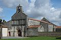
Saint Laurent Church

Puydrouard Mill


literature
- Le Patrimoine des Communes de la Charente-Maritime. Flohic Editions, Volume 1, Paris 2002, ISBN 2-84234-129-5 , pp. 51-54.
Web links
Commons : Forges - collection of images, videos and audio files