
Unstrut
| Unstrut | ||
 Catchment area of the Unstrut; In addition to the Unstrut itself, the tributaries Helme, Wipper, Helbe and Gera are also highlighted (from north to south). |
||
| Data | ||
| Water code | EN : 564 | |
| location | Thuringia , Saxony-Anhalt | |
| River system | Elbe | |
| Drain over | Saale → Elbe → North Sea | |
| source | near Kefferhausen in Eichsfeld 51 ° 18 '58 " N , 10 ° 16" 35 " E |
|
| Source height | 400 m | |
| muzzle | Großjena near Naumburg in the Saale Coordinates: 51 ° 10 ′ 33 " N , 11 ° 48 ′ 7" E 51 ° 10 ′ 33 " N , 11 ° 48 ′ 7" E |
|
| Mouth height | 102 m | |
| Height difference | 298 m | |
| Bottom slope | 1.6 ‰ | |
| length | 192 km | |
| Catchment area | 6,364.2 km² | |
| Discharge at the Laucha A Eo gauge : 6218 km² Location: 12.8 km above the mouth |
NNQ (29.06.1960) MNQ 1946–2014 MQ 1946–2014 Mq 1946–2014 MHQ 1946–2014 HHQ (12.02.1946) |
4.6 m³ / s 10.8 m³ / s 30.3 m³ / s 4.9 l / (s km²) 106 m³ / s 363 m³ / s |
| Left tributaries | Notter , Schambach , Sächsische Helbe *, Helbe , Schwarzburger Helbe *, Wipper , Flutgraben , Solgraben *, Kleine Helme *, Helme , Schmoner Bach (*: secondary and connecting arms) | |
| Right tributaries | Luhne , Felchtaer Bach , Seebach , Suthbach , Orlbach , Salza , Tonna , Gera , Gramme , Lossa , Unstrut-Lossa *, Flutkanal * ( inc.Helderbach ), Biberbach , Hasselbach (*: secondary and connecting arms) | |
| Medium-sized cities | Mühlhausen , Sömmerda , Naumburg | |
| Small towns | Dingelstädt , Bad Langensalza , Artern , Roßleben-Wiehe , Nebra , Freyburg | |
| Navigable | Naumburg-Freyburg-Karsdorf | |
 The Unstrut in Roßleben |
||
The Unstrut ([ ˈʊnʃtruːt ], sometimes also [ ˈʊnstruːt ]) is an approximately 192 km long left tributary of the Saale and its tributary with the most water. The catchment area is almost the entire Thuringian Basin along with part of the western and northern edge plates, parts of the southern Harz and smaller parts of the northern Thuringian Forest . The tributaries, which are richer in water, as well as the Unstrut themselves, arise in the peripheral mountains, which are more precipitated than the basin.
Surname
In 575 the river was called Onestrudis , in the 7th century Unestrude , in 994 Vnstruod . The name is derived from the Germanic strōdu , which means swamp thicket . For the prefix Un- , a form of augmentation such as in “storm” is being considered or a form of local particles * (h 1 ) en , in '. The river name would therefore mean "swamp (thicket) with (the river)", which is also supported by the floodplain landscape and flood hazard typical of the Unstrut. A similar word formation can be found in the Austrian Erlauf (formerly: Arelape ), (river,) which has a lake in front / at the beginning '.
geography
course
The Unstrut rises west of Kefferhausen near Dingelstädt in northern Thuringia in southern Eichsfeld . In the Thuringian Gate near Sachsenburg it breaks through the Hainleite . In its lower reaches, it flows in numerous loops through the Burgenland district in southern Saxony-Anhalt . It is flanked below Memleben by the Ziegelrodaer Plateau , at Laucha by the Dorndorfer Plateau and near Freyburg by the lime-rich Silent Mountains and flows into the Saale in Großjenaer Blütengrund near Naumburg .
At the confluence with the Saale, the Unstrut is shorter (192 vs. 255 km) and has less water than this (45%: 55%), but it drains a larger catchment area (55%: 45%).

The source of the Unstrut

The Unstrut near Bad Langensalza

Cliffs on the Unstrut between Memleben and Wangen
Unstruttal above Nebra

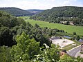
Muzzle in the flower base near Großjena


River system
_in_Wollersleben.jpg)
Measured against its catchment area of over 6,000 km², the Unstrut is comparatively poor in water with only about 30 m³ / s discharge ( discharge rate : just under 5 l / s · km²). This is caused on the one hand by the widespread flatness of the Thuringian Basin, on the other hand by the fact that the upper reaches of the larger tributaries as well as the Unstrut itself come from the leeward side of the peripheral mountains. Even the Gera, which drains the montane Thuringian Forest in the upper reaches, only reaches 7 l / s · km², while the rivers draining to the Werra on the windward side of the mountains (e.g. sluice ) carry more than twice the amount of water per square kilometer of the catchment area.
Important tributaries of the Unstrut are the Wipper (catchment area: 647 km²), Helbe (414 km²) and Helme (1,318 km²) on the left; on the right, next to the Gera (1,090 km²), the Gramme (357 km²) and the Lossa (394 km²) are important. The largest tributary, the Gera, clearly exceeds the Unstrut in terms of water flow at the mouth (6.6 m³ / s vs. 4.6 m³ / s).
From the main rivers of the river system, many branch off, mostly artificial tributaries, which in turn accommodate numerous drainage ditches. For example, the Helbe flows into three parallel arms.
geomorphology
Red sandstone and shell limestone from the Triassic formation shape the face of the Saale-Unstrut- Triassic region . In some places they are covered by tertiary and quaternary sediments, in other places they are exposed. The geological sequence of layers can be seen particularly well in the lower reaches.
The breakthrough valley of the Thuringian Gate separates the Hainleite and Schmücke mountain ranges , which border the Thuringian Basin in the north and northeast, and consist of shell limestone. The gypsum rock of the Wendelstein , which rises steeply just before Memleben directly on the Unstrut, is one of the bulges of the Zechstein , as the eastern branch of the Bottendorfer Höhe , which comes to light here due to the northern edge fault of the Hermundurian plaice . Between Memleben and Nebra, the Unstrut flows through a valley cut into the middle red sandstone, whose quarry walls tell of centuries of stone mining. In Karsdorf , the valley, the soft expands shale of the Upper Bunter was washed out here partly from the river. The lime is extracted as a raw material in the Karsdorf cement works. From Karsdorf to Freyburg, vine-bearing elevations of the Lower Muschelkalks accompany the Unstrut; the limestone, which is flat to wavy, and in some cases compact, was exposed over a large area by the river. Freyburger foam lime was used in previous centuries, among other things, in Naumburg Cathedral .
Probably the Unstrut once turned from the inflow of the Helme to what is now the Mansfelder Land, flowed through the depression occupied by the former Salziger See and then reached the Saale via today's Salzatal . In the rubble of the lake and the Salza you will find stones that come from the Thuringian Basin and cannot have been brought there by the current waters. When the Hornburger Sattel and its neighboring heights rose, the Unstrut's old drainage path was blocked, whereupon it found a new one in the direction of its current valley near Freyburg.
Natural spaces, climate, flora and fauna
In its entire course, the Unstrut lies in the lee of the Harz Mountains, climatically this results in a low to moderate annual rainfall, since most of the rainfall falls in the northwest in front of the mountains, as well as a continental climate with around 1600 hours of sunshine per year. In the lower reaches of the Unstrut valley forms a warm island shielded from northerly winds, whose steep south-facing slopes can receive almost perpendicular rays of sunlight even in winter.
The Unstrut gains its special charm from the contrast between floodplain biotopes and adjacent dry soils. The damp banks are lined with willow, poplar and ash. On the dry, chalky soils found arid and semi-arid grasslands, in sheltered places such as the nature reserve Dead valleys grow rare orchids such as bleach and purple orchid , the bee , spider and fly orchid , the lady's slipper or Twayblade .
The Unstrut region is a centuries-old cultural landscape, which is characterized especially by the vineyards and the orchards , from vineyard broke emerged. Water-loving birds such as the dipper and the kingfisher are native here, and since the 1990s the cormorant , which fishermen are reluctant to see as a competitor, has been increasingly found.
Water quality, water protection
Measurements carried out in 2004 from the source to the mouth showed a high level of nitrate pollution in the Unstrut. The water conservationists found a greatly increased value of 29.7 mg / l at the source near Kefferhausen. The concentration decreased in the course up to a value of 13 mg / l near the mouth. However, the “Council of Experts for Environmental Issues” (SRU) even requires nitrate levels below 8 mg / l in the rivers flowing into the North Sea in order to reduce their current eutrophication . According to the chemical-physical water quality classification of the state working group on water (LAWA), the Unstrut in the upper watercourse up to Bad Langensalza is to be regarded as heavily polluted with nitrates. When examining the tributaries, a comparable nitrate concentration was found in the Gera and a lower concentration in the helmets. The reason is that the groundwater in the upper reaches is heavily polluted by fertilizer input. To reduce this, the water conservationists demand that additional taxes be levied for nitrogen-rich fertilization, such as for the widely practiced manure management. However, because large amounts of nutrients have accumulated in the groundwater over the past few decades, this measure would take a long time to reach the limit values.
For short to medium-term nitrate relief, it is necessary to promote self-cleaning, for example by adding rainwater to the groundwater and opening the bank zones for flooding. “Alluvial meadows with their positive influences on the self-cleaning power must be reactivated. As a positive side effect, flood and nature protection are also carried out ”, formulates the VSR water protection.
history
Battles and skirmishes near Unstrut

In 531, according to Gregor von Tours ' Decem libri on the Unstrut, the decisive battle between Franks and Thuringians took place, which ended with the annihilation and annexation of the Thuringian Empire into the Franconian Empire.
In the battle of riade at the Unstrut 933 the Magyars were first by a German army under Henry I hit.
On June 9, 1075, King Heinrich IV defeated a Saxon army consisting mainly of simple farmers in the battle of Homburg an der Unstrut (former Homburg monastery, about 1 km north of Bad Langensalza), only to wreak havoc through Saxony and Thuringia. This finally led to the complete submission of the Saxon leaders at Spier (Sondershausen) on October 27th. Heinrich IV then held numerous Saxon greats in custody in various places and gave their fiefs elsewhere.
From October 19 to 21, 1813, the French army defeated in the Battle of Leipzig crossed the Unstrut near Freyburg and at the Zeddenbachmühle, and once again there was a bloody battle. Around 100,000 men rolled over the makeshift bridges built by French pioneers. Napoleon himself supervised and directed the transition. The French had commanded their cannons on the heights of the Schweigenberge and near Zscheiplitz and were able to stop the allies who were advancing, so that further retreat was secured. The Russians and Prussians did not cross the Unstrut until October 22nd.
Making navigable


Shipping on the Unstrut has been documented since at least 1612; However, due to the shallow river depth and the boggy banks, a significant economic use was not possible for a long time. Again and again the residents had to maintain the boardwalks be stopped that one for the towing required the barges. The water and mill regulations of 1653, which were renewed several times , brought only a slight improvement; there was often extensive flooding. Plans to make navigable, which Duke Ernst I of Saxe-Gotha had in order to strengthen Naumburg economically as a transhipment point for goods, he submitted to his electoral relatives, but they were rejected by councilors of the Electorate of Saxony; they feared growing competition for the nearby trading city of Leipzig. Even a large-scale planning of a west-east waterway including the Unstrut in the middle of the 18th century did not materialize for a long time.
It was not until 1778 that the mining captain, machine and lock builder Johann Friedrich Mende was commissioned with investigations into making it navigable, and in 1790 with drawing up a canalization plan. In 1791 he took over the management of the extension works over 71 km on the Unstrut, which should guarantee a minimum depth of the river of 0.8 m. Three million thalers were allocated for the work. In the next few years twelve locks were built; an expansion also took place on the Saale route between Naumburg and Weißenfels . Shipping was opened on April 8, 1795, and the first barge docked in Artern on July 3.
The waterway ensured an increasing economic upswing, in particular the famous sandstone from Nebra , which was widely distributed, limestone from Freyburg, salt from Artern, as well as grain and beets. The ships were hauled upstream, so special attention was paid to bank reinforcements and walkable bank paths. The Unstrutregulierungs-Sozietät was founded in 1857 to drain the soils that were still damp and threatened by flooding. Productive agricultural use only became possible with amelioration . At the same time, the widespread Unstrut marsh fever was combated. A steam tug has been used since 1888. 1882–1895 the Unstrut waterway was partially straightened and recanalized. Economic competition arose from shipping when the Unstrut Railway opened between Naumburg and Artern on October 1, 1889; In the next decades, the traffic on the water decreased rapidly. After the massive spring floods in 1956 and 1967, an immediate flood protection program was started, straightened again and flood retention basins were created. Five weirs and locks were demolished. Continuous lock operation was no longer possible.

The waterway is no longer used economically today, but tourism has discovered the unstrut in recent years. Numerous water sports clubs and boat rental companies offer canoes or rowing boats with which you can travel the Unstrut. Locks are still in operation in Artern, Ritteburg, Wendelstein, Tröbsdorf, Laucha, Zeddenbach and Freyburg. Up until 2016, three small passenger ships operated on the Unterlauf from Karsdorf to the confluence with the Saale in Naumburg's flower base, the Fröhliche Dörte , built in 1888 , the Unstrutnixe built in 1908 and the phylloxera , built in 1969 .
The floodplain landscape of the Unstrut has suffered severely from the straightening and amelioration measures. In 1992 the Free State of Thuringia started a model project to revitalize the river.
Locks
The prerequisite for the start of shipping on the Unstrut in April 1795 between Bretleben (km 78.5) and the confluence with the Saale were, among other things, the construction of 12 locks between Artern (km 65.0) and Freyburg (from 1791 to 1795) km 5.2) as well as measures to expand the river (widening and deepening). The main dimensions of the locks were: gate widths between 5.52 m and 5.65 m and chamber lengths between 50.50 m and 51.50 m. The traffic of ships up to 150 t deadweight was possible. According to an announcement of December 30, 1936, the permissible ship dimensions on the Unstrut were still 5.50 m wide and 44.50 m long in the 20th century. From 1826 through the further expansion of the Saale, continuous shipping from Artern / Unstrut to Halle / Saale was possible.
Attractions


Directly on the Unstrut are the Wendelstein castle ruins , on which there are still inhabited buildings. In the 10th century there was an Ottonian imperial palace in Memleben , which was frequently visited by Heinrich I and Otto the Great . In today's place you can still find the foundation walls of the associated monastery and the partially preserved monastery church from the 13th century. A permanent exhibition provides information about the history of the Palatinate and the monastery.
In the Ziegelroda Forest, which stretches north of the Unstrut near Wangen, the Nebra Sky Disc was found on the Mittelberg . The baroque castle of Burgscheidungen , in which the future Countess Cosel lived for several years , is currently not open to the public.
The Unstruttal bridge on the new ICE route Erfurt – Leipzig / Halle near Karsdorf , which went into operation in December 2015, is the second longest railway bridge in Germany.
A bell museum with an original bell foundry workshop from 1790 can be visited in Laucha . There is a moated castle in Balgstädt , which today serves as a municipal office and hostel. To the south of the village is the Dead Täler nature reserve, which is home to rare plant species, especially orchids. In Zscheiplitz , the reconstructed monastery church and the estate of a former Benedictine monastery used by a winery can be visited with a view of the Unstrut valley.
The well-preserved Neuchâtel rises above Freyburg with a late Romanesque double chapel and a somewhat secluded donjon , the "Dicken Wilhelm". The castle houses a museum. Parts of the historic city wall are still preserved in the city. The Rotkäppchen Sektkellerei is one of the oldest sparkling wine houses in Germany. Shortly before the river flows into the Saale, the Max Klinger House, the last residence of the Leipzig painter Max Klinger (1857–1920), is located on a vineyard , and his grave is right next to it. Shortly before the river flows into the Saale (Großjena), a baroque relief from 1722 is carved into the sandstone of the Markgrafenberg, the so-called “ stone picture book ”.
Naumburg has a historic city center, the Naumburg Cathedral with its well-known donor figures and the Passion relief of the West Lettner is a tourist magnet .
Viticulture

The Saale-Unstrut wine-growing region lies on the lower reaches of the Unstrut and is opened up to tourism by the 13th German Wine Route, which was opened in 1993 . The viticulture is favored by the shell limestone mountains on the north side of the river. It was first mentioned in a document in 998 in a certificate from Otto III. The heyday of the Thuringian-Saxon winery was in the 16th century; At that time the wine trading places were Jena, Naumburg and Leipzig. In the following years the cultivation declined. In 1835 the Naumburger Weinbaugesellschaft was founded. In 1887 there were still 1000 hectares of vineyards, in the same year as everywhere the onset of phylloxera infestation came , so that by 1900 there were only 31 hectares of vineyards on the Unstrut. With the cultivation of refined vines, the winemaking business recovered over time. The total cultivation area is currently about 640 hectares; The region is one of the smallest wine-growing areas in Germany. At the moment, especially early-ripening vines such as Silvaner and Müller-Thurgau are grown.
The climatic conditions are favorable despite the northern location. The average rainfall is 500 mm, the average annual temperature is 9.1 ° C and the average July temperature is 18.7 ° C. During the year, the sun shines for an average of 1606 hours, as in the wine-growing regions in Rhineland-Palatinate and Franconia . The average vegetation period is 186 days with fluctuations between 155 and 225 days. The conditions are roughly the same as in Franconia, but Unstrut viticulture is 100 to 200 m above sea level due to the lower altitude . NN less endangered by frosts.
High water marks
Despite extensive hydraulic engineering measures in the second half of the 19th century, floods occurred again and again. The Unstrut caused great floods in February 1909 and in the summer of 1926. Between 1888 and 1945 (57 years) a total of 163 floods were registered at the Unstrut gauge in Straußfurt . The events of January 1682, February 1784, February 1799, June / July 1871 and March 1881 are among the particularly severe floods before 1888.
All major floods on the Unstrut are documented several times in the form of high water marks. A total of 71 markings are known from four centuries, 44 of which were found on the 145 km long section of the river in Thuringia and 27 on the 45 km long Unstrut run in Saxony-Anhalt. In addition, 43 destroyed brands (42 of them in Thuringia) were identified.

The oldest stamp is the year "1613", which is carved in stone and is, with five others, on the St. Georgi Church in Mühlhausen / Thuringia . According to manuscripts in the city archives, it refers to the Thuringian Flood of May 29, 1613, during which numerous rivers in Thuringia were flooded. The assignment to the event of May 29, 1613 is confirmed by church accounts. While five other marks along the Unstrut date from the 17th century, there are 15 high water marks from the 18th and 19th and 30 from the 20th century. Five characters could not be assigned due to missing information. 17 stamps with exact dates (day, month, year) were recorded along the course of the river.
More extensive inscriptions relating to a specific flood are missing on the Unstrut. There are also no references to chronograms or designed memorial plaques. The only special shapes identified were two stones set up in the field. One stone stands south of Ringleben ( Kyffhäuserkreis ) on a field. The memorial made of red sandstone is 155 cm high. The slightly weathered inscription is carved: “Memorial stone of the great flood on June 28, 1871”. The second, only preserved as a replica, stands between the old kilometer stones 1.6 and 1.7 on a supply route between Ritteburg and Gehofen (Kyffhäuserkreis). The original was erected after the catastrophic flood of June 1871. On the red sandstone was the inscription "Water level on June 29, 1871" 1.60 m above the top of the dam. After the heavy floods of 1946 and 1947, which exceeded the water level of 1871, a plate with the information "9.2.1946" and "16.3.1947" was put on. Until it was destroyed a few years ago, the so-called “water stone” stood in the field. The installation of a replica in June 1996 is thanks to the efforts of the Heimatfreunde.
The most recently recorded mark of the study refers to the summer floods of 1956. The color marking “1956” can be found with three other symbols (1939, 1946, 1947) under the heading “Flood levels” on a direction finder on the Laucha lock bridge . While the winter floods of 1939 were relatively unscathed, in February 1946 and March 1947 local catastrophic destruction occurred along the Unstrut. Nine brands bear witness to the enormous water level in 1946. 11 high water marks refer to the event of March 1947. The severe winter floods of February / March 1784 must have reached a similar extent. At that time there were also extraordinary floods on the Main and Elbe. Four high water marks indicated the event of 1784 on the Unstrut. Even higher tides occurred 15 years later.
Seven brands announce the event in February 1799. In particular, the streets and alleys in the suburbs of Freyburg repeatedly suffered from flooding. In a letter from the Freyburg City Council dated February 27, 1799, published in the Leipziger Zeitung, it is noted that the flood of 1799 was 2 cubits higher than it was in 1784. The letter from the Freyburg Council to the state government in Dresden put the damage in the city at 5352 thalers . There is talk of 43 houses, some of which were completely ruined, others were considerably damaged. Until well into the 19th century, this flood was a benchmark for other floods in the Unstrut, including the old mark in Wasserstraße 32.
additional

In the summer there are numerous events on and on the river, such as the defense and lock festival in Freyburg and the bathtub race in Weischütz. The Unstrut cycle path runs along the entire course of the river .
literature
- The area on the lower Unstrut (= values of our homeland . Volume 46). 1st edition. Akademie Verlag, Berlin 1988.
- Gerlinde Schlenker , Jürgen Laubner: The Unstrut. Portrait of a cultural landscape . Mitteldeutscher Verlag, Halle 2002, ISBN 3-89812-137-2 .
- Hermann Großler : Guide through the Unstrut Valley from Artern to Naumburg for past and present. Edited edition of the original print from 1904. 2nd edition. Dingsda-Verlag, Freyburg 1995, ISBN 3-928498-04-5 .
- Harald Rockstuhl : The Unstrut - aerial photo atlas. From the source to the mouth - 192 km. Bad Langensalza 2011, ISBN 978-3-86777-405-5 .
- Christel Foerster, Christian Kupfer: Lower Unstruttal. Greifenverlag, 1992, ISBN 3-7352-0295-0 .
- Fritz Kühnlenz: Cities and castles on the Unstrut. Publishing house Thuringia, 1999, ISBN 3-89683-121-6 .
- Th. Sommer, G. Hesse: Hydrogeology of an anthropogenic river landscape - the Unstruttal between the source and Sömmerda (Thuringian basin). In: Jber. Mitt. Upper Rhine. Geol. Ver. New episode 84, Stuttgart 2002.
- Michael Eile, H.-J. Strumpf: The Unstrut Waterway 2010, Measurement Expedition Radegunde , Gotha 2011, ISBN 978-3-00-034423-7
- Andreas Schmölling, Klaus Schmölling: 200 Years of the Navigable Unstrut 1795–1995. Heimatverein Artern, 1995, DNB 945473303 .
- Rudolf Thomaszewski: The making of the Unstrut navigable in the years 1791–1795 and its last witnesses. In: Sächsische Heimatblätter. 36 (1990) 3, pp. 133-139.
- Christian Kupfer, Michael Pantenius: The wine route on Saale and Unstrut - cultural landscape in Central Germany. Mitteldeutscher Verlag, 1997, ISBN 3-932776-01-1 .
- Harald Rockstuhl (ed.): Unstrut saga book. The most beautiful legends from the source to the mouth. Bad Langensalza 2007, ISBN 978-3-938997-81-9 .
- Frank Boblenz: Legends of the Unstrut-Finne region. Sömmerdaer Heimatheft, special issue 1, Sömmerda 1999.
- Wolfgang Gresky: The Unstrut - your source and your name. In: Eichsfelder Heimatstimmen. 23rd year (1979), Verlag Mecke Duderstadt, pp. 162-165
Individual evidence
- ↑ a b c d Thuringian State Agency for the Environment (ed.): Area and waterway key figures (directory and map). Jena 1998.
- ^ German Hydrological Yearbook Elbe Region, Part I 2014. (PDF) State Office for Flood Protection and Water Management Saxony-Anhalt, p. 174 , accessed on November 3, 2018 (from: lhw.sachsen-anhalt.de).
- ↑ a b c Map of the flowing waters of Thuringia ( Memento of the original from July 19, 2011 in the Internet Archive ) Info: The archive link was inserted automatically and has not yet been checked. Please check the original and archive link according to the instructions and then remove this notice. - PDF, 1.23 MB
- ↑ Bichlmeier, Harald, Opfermann, Andreas: A new proposal for the etymology of the river name Unstrut . In: onenological information 99/100 [2011 (2013)], pp. 173–204. ( Online version )
- ↑ The Saale runs directly below the Unstrut confluence, at the Naumburg gauge ( memento of the original from August 27, 2011 in the Internet Archive ) Info: The archive link was automatically inserted and not yet checked. Please check the original and archive link according to the instructions and then remove this notice. , an MQ of 67 m³ / s, of which 30.2 come from the Unstrut; the length of the river Saale to its mouth is given there as 158 km, which must be deducted from the total length of 413 km.
- ↑ Thuringian State Institute for the Environment (ed.): Area and water code index and map. Jena 1998; 26 S. (Saale before Unstrut: 5097.2 km²)
- ↑ Gauge values from Erfurt-Möbisburg (Gera) and Nägelstedt (Unstrut), increased by the drainage of the remaining catchment area (but without the Schmale Gera ). The respective remaining catchment areas are sub-areas of the intermediate catchment area of the Nägelstedt , Erfurt-Möbisburg and Wangen gauges ( Oldisleben excluded due to obviously incorrect MQ and MHQ values), which has an area discharge of 4.4 l / s km². The water of the Schmalen Gera only reaches the Unstrut after the Straussfurt Unstrut level has been bypassed . Therefore, without taking into account an average flow rate of the Schmaler Gera of around 300 l / s, the Mq value of the adjacent intermediate catchment area above is reduced and that of the one below is increased. The result is an average discharge of the Gera of just under 6.9 m³ / s (without Schmale Gera) and for the Unstrut of around 4.6 m³ / s.
- ^ Friedrich Gollmick, Harald Bocker, Hermann Grünzel: Das Weinbuch. Fachbuchverlag, Leipzig 1976.
- ↑ M. Deutsch, K.-H. Pörtge: Exceptional rainfall and floods in Thuringia using the example of the Unstrut flood of July 1926 in the old district of Mühlhausen / Thuringia. In: R. Mäusbacher and A. Schulte (Eds.), Contributions to Physiogeography. Festschr. for Dietrich Barsch, Heidelberg geographer. Arb. 104, 1996 pp. 289-299.
- ↑ M. Deutsch: Hochwassermarken der Unstrut , 1994.
- ↑ M. Deutsch, K.-H. Pörtge: High water marks in Thuringia , Thuringian Ministry of Agriculture, Forests, Environment and Nature Conservation, 2009. ( PDF )
- ↑ Mühlhausen City Archives, Sign. 2371/1, fol. 545.
Web links
- Map of the rivers of Thuringia (TLUG Jena) - PDF, 1.23 MB
- The unstrut at the Blue Ribbon