
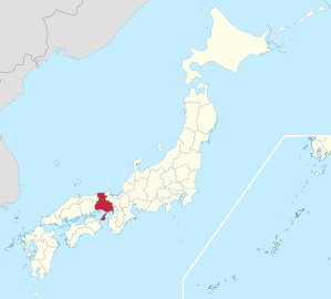
Hyogo Prefecture
|
Hyōgo-ken 兵 庫 県 |
|
|---|---|
  |
|
| Basic data | |
| Administrative headquarters : | Kobe |
| Region : | Kinki |
| Main island : | Honshu |
| Area : | 8,400.94 km² |
| Water content: | 0.6 % |
| Residents : | 5,463,609 (October 1, 2019) |
| Population density : | 650 inhabitants per km² |
| Counties : | 8th |
| Municipalities : | 41 |
| ISO 3166-2 : | JP-28 |
| Governor : | Toshizō Ido |
| Website: | web.pref.hyogo.jp |
| Symbols | |
| Prefecture flag : |
 |
| Prefecture tree : | Camphor tree |
| Prefecture flower : | Chrysanthemum japonense |
| Vogel prefecture : | Black-billed stork |
| Prefecture song : |
Furusato Hyōgo ("Home Hyōgo") |
The prefecture of Hyogo ( Jap. 兵庫県 , Hyogo-ken ) is a prefecture of Japan . It is located in the Kansai region northwest of Osaka on the island of Honshū . The seat of the prefecture administration is Kobe .
geography
The Sea of Japan is located in the north of Hyogo Prefecture , and in the south it borders on the Inland Sea . Hyōgo has been connected to the island of Awaji-shima since 1985 via the Naruto Bridge with Tokushima Prefecture on Shikoku . In 1998 the Akashi Kaikyō Bridge between Honshū and Awaji-shima was completed. In the west, Hyōgo borders on the prefectures Okayama and Tottori , in the east on Osaka and Kyoto .
Hyōgo is, apart from the two prefectures at the outer tips of Honshū, the only prefecture where both the northern and southern borders are by the sea. The middle part is mountainous . The climate in the prefecture is different: the south is protected from the seas by mountain ridges and has a relatively mild climate, especially in winter, while in the interior and north it is relatively cold with heavy snowfalls on the north coast.
The administrative center of Kobe is the largest city in Hyogo prefecture and a cultural and industrial center of Japan. The southern coastline from Osaka to almost the western edge of the prefecture is a consistently populated area with important industrial and research facilities.
The aristocratic seat of Himeji-jō , which was named a World Heritage Site in 1993, is also located in Hyōgo prefecture .
history
The name comes from the fishing village Hyōgo, today a district of Kobe , which was merged with the settlement of Kobe to form the new port city when Japan opened up. The current area of Hyōgo prefecture includes the former provinces of Harima , Tajima , Awaji and parts of the provinces of Settsu and Tamba (now the north of Osaka prefecture and the west of Kyoto prefecture ).
| Shogunate and Hatamoto lands : large parts of Tajima, north of Harima, several non-contiguous areas in Settsu & Tamba | |||
|---|---|---|---|
| Gosankyō families with lands in Settsu and Harima provinces: Tayasu-Tokugawa , Hitotsubashi-Tokugawa | |||
| Principalities (- han ) with their seat in the part of Settsu Province that is part of Hyōgo today | |||
| Han | Seat (+ today's municipality) | last prince | Territory (by income in Koku ) |
| Amagasaki | Amagasaki, Kawabe-gun ( Amagasaki -shi ) | [Sakurai-] Matsudaira Tadaoki | 40,000 |
| Sanda | Sanda, Arima-gun ( Sanda -shi ) | Kuki Takayoshi | 36,000 |
| Principalities based in Harima Province | |||
| Himeji | Himeji, Shikitō-gun ( Himeji -shi) | Sakai Tadayoshi / Tadatō ( 忠 惇 ) | 150,000 |
| Akashi | Akashi, Akashi-gun ( Akashi -shi ) | [Echizen] Matsudaira Yoshinori | 80,000 |
| Tatsuno | Tatsuno, Ittō-gun ( Tatsuno -shi) | Wakisaka Yasuaya | 51,000 |
| Ako | Akō, Akō-gun ( Akō -shi) | Mori Tadatsune | 20,000 |
| Mikazuki | Mikazuki, Sayo / Sayō-gun ( Sayō -chō) | Mori Toshishige | 15,000 |
| Ono | Ono, Katō-gun ( Ono-shi ) | Hitotsuyanagi Suenori | 10,000 |
| Mikusa | Mikusa, Katō-gun ( Katō-shi ) | Niwa Ujinori | 10,000 |
| Yamasaki | Yamasaki, Shisō-gun ( Shisō-shi ) | Honda Tadachika | 10,000 |
| Anji | Anji, Shisō-gun (Himeji-shi) | Ogasawara Sadazane | 10,000 |
| Hayashida | Hayashida, Shikitō-gun (Himeji-shi) | Takebe Masayo | 10,000 |
| Principalities located in the Tajima Province | |||
| Izushi | Izushi, Izushi-gun ( Toyooka -shi ) | Sengoku Hisatoshi | 30,000 |
| Toyooka | Toyooka, Konosaki-gun (Toyooka-shi) | Kyogoku Takaatsu | 15,000 |
| Principalities based in the part of Tamba Province that is now part of Hyōgo | |||
| Sasayama | Sasayama, Taki-gun ( Tamba-Sasayama -shi) | Aoyama Tadayuki | 60,000 |
| Kaibara | Kaibara, Hikami-gun ( Tamba -shi ) | Oda Nobuchika | 20,000 |
| Principalities with territory in the later Hyōgo, but seat outside | |||
| with possessions in Tamba: Yunagaya , Tsurumaki , Yamakami , [Tamba-] Kameyama / Kameoka | |||
| with possessions in Harima: Mibu , Koga , Oshi , Hamamatsu / Tsurumai , Marugame | |||
| with possessions in Settsu: Koga, Okabe / Hanbara , Asada , Koizumi , Asao | |||
| with practically all of Awaji: Tokushima | |||
| with Fukuura in Wake County of Bizen Province (in the 20th century to Hyōgo): Okayama | |||
| Several minor spiritual goods | |||
| (Not in the list: the Han Fukumoto and Muraoka, which were only established after the restoration, as well as the Aizu-han , whose [Aizu-] Matsudaira princes also held lands in today's Hyōgo that were linked to shogunate offices ) | |||
A first Hyōgo prefecture was founded in the Meiji Restoration in 1868 from the Hyōgo ( Kōbe ) port, which was opened due to the unequal treaties , and was originally only a small part of the present-day area: The first Hyōgo prefecture included the contract port and its surroundings mainly former shogunate countries in the provinces of Settsu and Harima, including at times parts of what is now Osaka and the northern part of Awaji. With the abolition of the Han in 1871 and the subsequent first consolidation of the resulting prefectures, today's area of Hyōgo was then divided between four prefectures: Hyōgo in the western part of Settsu, Shikama with the entire province of Harima, Toyooka with all of Tajima and Tango as well as part of Tamba and the Myōdō Prefecture , which emerged from the Principality of Tokushima , to which all of Awaji again belonged. During the second wave of consolidation in the prefectures in 1876, Hyōgo was merged with Shikama and parts of Toyooka and Myōdō and, with the exception of later minor border shifts, essentially received its current borders.


The first governor of Hyōgo was during the Restoration for a short time the Chōshū Samurai Itō Hirobumi , who later played a key role in shaping the state order of the empire as the leading Meiji oligarch , multiple prime minister and architect of the Meiji constitution . The first prefectural parliament was elected in 1879, as in most prefectures. In 1947 , as in all prefectures except Okinawa , the governor was elected by the people for the first time.
On January 17, 1995, about 4600 people were killed in the great Hanshin earthquake (magnitude 7.3) in South Hyōgo. In 2004 there were devastating floods in the northern part of the prefecture.
politics
Toshizō Ido has been governor of Hyōgo since 2001 , he was last re-elected for a fifth term in the July 2017 election. In the regular 86-member parliament, the Liberal Democratic Party (LDP) is clearly the strongest force: It won 27 seats in the elections in April 2019 , and a significant number of non-party MPs also join its group.
In the national parliament , Hyōgo directly elects twelve members to the House of Representatives and since 2016 three instead of two per partial election to the Council House , so it has been represented there by six members since 2019 . In the 2017 parliamentary elections , the seats in the prefecture went entirely to the governing coalition: ten Liberal Democrats and two Kōmeitō members; after the elections in 2016 and 2019 , Hyōgo will be represented in the council house by two members each from LDP, Nippon Ishin no Kai and Kōmeitō.
Administrative division
As in all Japanese prefectures, the number of parishes steadily decreased. If in 1920 there were still 425 municipalities - 4 of which were independent cities ( 市 , shi ) and 38 cities ( 町 , chō ) - their number had already fallen to more than half by 1955. From 1950 to 1955, the number of municipalities fell by 199 to 154. In 1998, there were 21 urban districts and 70 urban districts in the prefecture. As a result of incorporations and the establishment of new municipalities, the number of municipalities has decreased to currently (2018) 41 - 29 urban districts and 12 small towns belonging to the district.
The last village community ( 村 , mura ) was dissolved in 1962 by incorporation.
The number of counties ( 郡 , gun ) fell steadily. Since the end of World War II, 16 districts have been dissolved. There are currently 8 rural districts, 5 of which have only one city in each district.
In the table below, the districts ( 郡 ) are shown in italics, below each (indented) the small towns ( 町 ) within them. The independent cities are at the beginning of the table.
| code | Surname | Area (in km²) | population | Population density (inh / km²) |
||
|---|---|---|---|---|---|---|
| Rōmaji | Kanji | 01.10.2017 1 | 01.10.2018 2 | 01/10/2015 3 | ||
| 28100 | Kobe- shi | 神 戸 市 | 557.02 | 1,527,407 | 1,537,272 | 2759.81 |
| 28201 | Himeji- shi | 姫 路 市 | 534.48 | 531.298 | 535.664 | 1002.22 |
| 28202 | Amagasaki- shi | 尼 崎 市 | 50.72 | 451.072 | 452.563 | 8922.77 |
| 28203 | Akashi- shi | 明石 市 | 49.42 | 297.920 | 293,409 | 5937.05 |
| 28204 | Nishinomiya- shi | 西宮 市 | 99.96 | 488.126 | 487,850 | 4880.45 |
| 28205 | Sumoto- shi | 洲 本市 | 182.38 | 42,415 | 44,258 | 242.67 |
| 28206 | Ashiya- shi | 芦 屋 市 | 18.47 | 94,751 | 95,350 | 5162.43 |
| 28207 | Itami- shi | 伊丹 市 | 25.00 | 197,851 | 196,883 | 7875.32 |
| 28208 | Aioi- shi | 相 生 市 | 90.40 | 29,433 | 30,129 | 333.29 |
| 28209 | Toyooka- shi | 豊 岡 市 | 697.55 | 79,428 | 82,250 | 117.91 |
| 28210 | Kakogawa- shi | 加古川 市 | 138.48 | 263,697 | 267,435 | 1931.22 |
| 28212 | Akō- shi | 赤 穂 市 | 126.85 | 46,779 | 48,567 | 382.87 |
| 28213 | Nishiwaki- shi | 西 脇 市 | 132.44 | 39,611 | 40,866 | 308.56 |
| 28214 | Takarazuka- shi | 宝 塚 市 | 101.80 | 225,129 | 224.903 | 2209.26 |
| 28215 | Miki- shi | 三 木 市 | 176.51 | 75,823 | 77,178 | 437.24 |
| 28216 | Takasago- shi | 高 砂 市 | 34.38 | 88,956 | 91.030 | 2647.76 |
| 28217 | Kawanishi- shi | 川西 市 | 53.44 | 154.315 | 156.375 | 2926.18 |
| 28218 | Ono- shi | 小野 市 | 92.94 | 48,000 | 48,580 | 522.7 |
| 28219 | Sanda- shi | 三 田 市 | 210.32 | 111,512 | 112,691 | 535.81 |
| 28220 | Kasai- shi | 加西 市 | 150.98 | 43,496 | 44,313 | 293.5 |
| 28221 | Tambasasayama shi | 丹波 篠 山 市 | 377.59 | 40,320 | 41,490 | 109.88 |
| 28222 | Yabu- shi | 養父 市 | 422.91 | 22,910 | 24,288 | 57.43 |
| 28223 | Tamba- shi | 丹波 市 | 493.21 | 62,555 | 64,660 | 131.1 |
| 28224 | Minamiawaji -shi | 南 あ わ じ 市 | 229.01 | 45.167 | 46,912 | 204.85 |
| 28225 | Asago- shi | 朝 来 市 | 403.06 | 29,693 | 30,805 | 76.43 |
| 28226 | Awaji- shi | 淡 路 市 | 184.32 | 42,254 | 43,977 | 238.59 |
| 28227 | Shiso- shi | 宍 粟 市 | 658.54 | 35,698 | 37,773 | 57.36 |
| 28228 | Kato- shi | 加 東 市 | 157.55 | 40,516 | 40,310 | 255.86 |
| 28229 | Tatsuno- shi | た つ の 市 | 210.87 | 75,558 | 77,419 | 367.14 |
| 28300 | Kawabe-gun | 川 辺 郡 | 90.33 | 30,413 | 30,838 | 341.39 |
| 28301 | Inagawa-cho | 猪 名 川 町 | 90.33 | 30,413 | 30,838 | 341.39 |
| 28360 | Taka-gun | 多 可 郡 | 185.19 | 20.114 | 21,200 | 114.48 |
| 28365 | Taka-cho | 多 可 町 | 185.19 | 20114 | 21200 | 114.48 |
| 28380 | Kako-gun | 加 古 郡 | 44.05 | 64,153 | 64,759 | 1470.12 |
| 28381 | Inami-cho | 稲 美 町 | 34.92 | 30,492 | 31,020 | 888.32 |
| 28382 | Harima-cho | 播 磨 町 | 9.13 | 33,661 | 33,739 | 3695.4 |
| 28440 | Kanzaki gun | 神 崎 郡 | 330.70 | 42.091 | 43,490 | 131.51 |
| 28442 | Ichikawa-cho | 市 川 町 | 82.67 | 11,625 | 12,300 | 148.78 |
| 28443 | Fukusaki-cho | 福 崎 町 | 45.79 | 19,528 | 19,738 | 431.05 |
| 28446 | Kamikawa-cho | 神 河 町 | 202.23 | 10,938 | 11,452 | 56.63 |
| 28460 | Ibo gun | 揖 保 郡 | 22.61 | 33,548 | 33,690 | 1490.05 |
| 28464 | Taishi-cho | 太子 町 | 22.61 | 33,548 | 33,690 | 1490.05 |
| 28480 | Akō-gun | 赤 穂 郡 | 150.26 | 14,373 | 15,224 | 101.32 |
| 28481 | Kamigōri-chō | 上郡 町 | 150.26 | 14,373 | 15,224 | 101.32 |
| 28500 | Sayō-gun | 佐 用 郡 | 307.44 | 16.308 | 17,510 | 56.95 |
| 28501 | Sayo-cho | 佐 用 町 | 307.44 | 16.308 | 17,510 | 56.95 |
| 28580 | Mikata gun | 美方 郡 | 609.78 | 30,760 | 32,889 | 53.94 |
| 28585 | Kami-cho | 香 美 町 | 368.77 | 16.802 | 18,070 | 49.00 |
| 28586 | Shin'onsen-chō | 新 温泉 町 | 241.01 | 13,958 | 14,819 | 61.49 |
| Shi-bu (proportion of urban districts) | 市 部 | 6660.57 | 5,231,690 | 5,275,200 | 792.00 | |
| Gun-bu (proportion of counties) | 郡 部 | 1740.38 | 251.760 | 259,600 | 149.16 | |
| 28000 | Hyōgo-ken (Hyōgo Prefecture) | 兵 庫 県 | 8400.94 | 5,483,450 | 5,534,800 | 658.83 |
swell
1 Area data from 2017
2 Estimated population 2018
3 Results of the 2015 census
Biggest places
| Census year | Residents | |||
|---|---|---|---|---|
| 2015 | 2010 | 2005 | 2000 | |
| Kobe | 1,537,272 | 1,544,200 | 1,525,393 | 1,493,398 |
| Himeji | 535.664 | 536.270 | 482,304 | 478,309 |
| Nishinomiya | 487,850 | 482,640 | 465,337 | 438.105 |
| Amagasaki | 452.563 | 453.748 | 462,647 | 466.187 |
| Akashi | 293,409 | 290,959 | 291.027 | 293.117 |
| Kakogawa | 267,435 | 266.937 | 267.100 | 266.170 |
| Takarazuka | 224.903 | 225,700 | 219,862 | 213.037 |
| Itami | 196,883 | 196.127 | 192.250 | 192.159 |
| Kawanishi | 156.375 | 156.423 | 157,668 | 153,762 |
| Sanda | 112,691 | 114.216 | 113,572 | 111,737 |
| Ashiya | 95,350 | 93,238 | 90,590 | 83,834 |
| Takasago | 91.030 | 93.901 | 94,813 | 96.020 |
| Toyooka | 82,250 | 85,592 | 89.208 | 47,308 |
| Tatsuno | 77,419 | 80,518 | 81,561 | 40,550 |
| Miki | 77,178 | 81.009 | 75,087 | 76,682 |
| Tamba | 64,660 | 67,757 | 70,810 | —— |
| Ono | 48,580 | 49,680 | 49,761 | 49,432 |
| Ako | 48,567 | 50,523 | 51,794 | 52,077 |
| Minamiawaji | 46,912 | 49,834 | 52.283 | —— |
| Kasai | 44,313 | 47.993 | 49,396 | 51,104 |
| Sumoto | 44,258 | 47,254 | 38,929 | 41,158 |
| Awaji | 43,977 | 46,459 | 49,078 | —— |
| Tambasasayama | 41,490 | 43,263 | 45,245 | 46,325 |
| Nishiwaki | 40,866 | 42,802 | 43,953 | 37,768 |
| Kato | 40,310 | 40.181 | —— | —— |
| Shisō | 37,773 | 40,938 | 43,302 | —— |
| Asago | 30,805 | 32,814 | 34,791 | —— |
| Aioi | 30,129 | 31,158 | 32,475 | 34,320 |
| Yabu | 24,288 | 26,501 | 28,306 | —— |
On April 1, 1999, the small town of Sasayama merged with 4 municipalities and was raised to the status of an independent city.
On April 1, 2004, the small town of Yabu merged with 3 municipalities and was raised to the status of an independent city.
On November 1, 2004, 6 municipalities merged to form the independent city of Tamba .
On November 1, 2005, 4 communities merged to form the independent city of Minamiawaji .
On April 1, 2005, 4 communities merged to form the independent city of Shisō .
On April 1, 2005, the small town of Awaji merged with 4 municipalities and was raised to the status of an independent city.
On April 1, 2005, the small town of Asago merged with 3 municipalities and was raised to the status of an independent city.
On March 20, 2006, 3 communities merged to form the independent city of Katō .
Population development in the prefecture
| Census year |
Total population |
male population |
female population |
Gender ratio men to 1000 women |
Area in km 2 |
Population density per km 2 |
|---|---|---|---|---|---|---|
| 1920 | 2 301 799 | 1 175 426 | 1 126 373 | 1044 | 8427.14 | 273.1 |
| 1925 | 2,454,679 | 1,239,326 | 1 215 353 | 1020 | 8427.14 | 291.3 |
| 1930 | 2,646,301 | 1,332,918 | 1,313,383 | 1015 | 8321.88 | 318.0 |
| 1935 | 2,923,249 | 1,466,284 | 1,456,965 | 1006 | 8322.85 | 351.2 |
| 1940 | 3,221,232 | 1 622 778 | 1,598,454 | 1015 | 8322.85 | 387.0 |
| 1945 | 2,821,892 | 1,344,778 | 1 477 114 | 910 | 8322.85 | 339.1 |
| 1950 | 3 309 935 | 1 622 755 | 1 687 180 | 962 | 8332.32 | 397.2 |
| 1955 | 3,620,947 | 1 773 488 | 1,847,459 | 960 | 8329.92 | 434.7 |
| 1960 | 3 906 487 | 1,917,887 | 1 988 600 | 964 | 8329.92 | 469.0 |
| 1965 | 4 309 944 | 2 120 749 | 2 189 195 | 969 | 8342.47 | 516.6 |
| 1970 | 4,667,928 | 2,299,961 | 2,367,967 | 971 | 8350.89 | 559.0 |
| 1975 | 4 992 140 | 2,453,277 | 2,538,863 | 966 | 8362.94 | 596.9 |
| 1980 | 5 144 892 | 2 512 358 | 2,632,534 | 954 | 8373.16 | 614.5 |
| 1985 | 5 278 050 | 2,567,814 | 2,710,236 | 948 | 8377.98 | 630.0 |
| 1990 | 5 405 040 | 2,619,692 | 2,785,348 | 941 | 8381.68 | 644.9 |
| 1995 | 5,401,877 | 2,612,369 | 2,789,508 | 937 | 8386.60 | 644.1 |
| 2000 | 5 550 574 | 2,674,625 | 2,875,949 | 930 | 8392.03 | 661.4 |
| 2005 | 5,590,601 | 2,680,288 | 2 910 313 | 921 | 8394.92 | 666.0 |
| 2010 | 5 588 133 | 2,673,328 | 2 914 805 | 917 | 8396.13 | 665.6 |
| 2015 | 5,534,800 | 2,641,561 | 2,893,239 | 913 | 8400.96 | 658.8 |
Outline

Kobe Harbor in Kobe
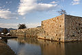
Akō Castle in Akō

Ikuno in Asago
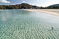
Takeno Beach in Toyooka

1000-year-old katsura tree Wachi no Ōkatsura in Kami

Road signs in Hyogo Prefecture


Web links
Individual evidence
- ↑ Prefecture Administration of Hyōgo : Materials on History, 幕末 の 大名 領 ("Principalities in Bakumatsu")
- ↑ Hyōgo prefecture administration: materials on history, 県 域 の 変 遷 ("Changes to the prefecture area")
- ↑ Hyōgo Prefectural Parliament : Group overview , accessed on August 9, 2019.
- ↑ 統一 地方 選 2019 兵 庫 県 議 選 各 党 議席 . In: NHK Senkyo Web. April 8, 2019. Retrieved August 9, 2019 (Japanese).
- ↑ Kokudo Chiriin (GSI - Geospatial Information Authority of Japan), 平 成 29 年 全国 都 道 府 県 市区 町 村 別 面積 調 (Nationwide survey of all prefectures and municipalities 2017) , p. 69: 28 Hyogo-ken (Japanese), accessed on 1 January 2019
- ↑ 簡 単 検 索 ・ 詳細 検 索 ・ 検 索 サ ン プ ル , accessed January 1, 2019 (Japanese)
- ↑ e-stat (English), accessed on January 1, 2019
- ↑ e-Stat database , accessed on January 1, 2019 (English)
Aichi | Akita | Aomori | Chiba | Ehime | Fukui | Fukuoka | Fukushima | Gifu | Gunma | Hiroshima | Hokkaidō | Hyōgo | Ibaraki | Ishikawa | Iwate | Kagawa | Kagoshima | Kanagawa | Kochi | Kumamoto | Kyoto | Mie | Miyagi | Miyazaki | Nagano | Nagasaki | Nara | Niigata | Ōita | Okayama | Okinawa | Osaka | Saga | Saitama | Shiga | Shimane | Shizuoka | Tochigi | Tokyo | Tokushima | Tottori | Toyama | Wakayama | Yamagata | Yamaguchi | Yamanashi
Coordinates: 35 ° 0 ' N , 134 ° 55' E