
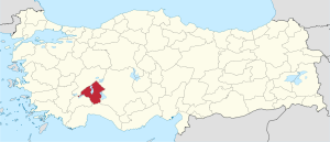
Isparta (province)
| Isparta | |
|---|---|
| Province number: | 32 |
  |
|
| Counties | |
.svg) |
|
| Basic data | |
| Coordinates: | 37 ° 57 ' N , 30 ° 58' E |
| Provincial capital: | Isparta |
| Region: | Mediterranean region |
| Surface: | 8,946 km² |
| Population: | 441,412 (2016) |
| Population density: | 49 inhabitants / km² |
| Political | |
| Governor: | Ömer Seymenoğlu |
| Seats in Parliament: | 4th |
| Structural | |
| Telephone code: | 0246 |
| Features : | 32 |
| Website | |
| www.isparta.gov.tr (Turkish) | |
Isparta is a province of Turkey and is located in the northwestern part of the Mediterranean region . The adjacent provinces are (starting in the north and going clockwise) Afyonkarahisar , Konya , Burdur and Antalya . The province of Isparta ranks 45th in the ranking of the most populous provinces. The provincial capital is Isparta .
Isparta is known for its roses, rose products and hand-knotted carpets. The province is also known for its apples, sour cherries and grapes.
In addition to the 482 km² Eğirdir Gölü , the second largest freshwater lake in Turkey, there are many other freshwater lakes. These include Gölcük Gölü , Kovada Gölü , Beyşehir Gölü and Burdur Gölü .
history
The area of today's Isparta province was the core area of the principality (Turkish: Beylik ) of the Hamidoğulları , also called Hamididen , in the 14th century . The last of the Hamidoğulları dynasty, Hamitoğlu Kemaleddin Hüseyin Bey, sold his principality to the Ottoman Sultan Murad I for 80,000 gold pieces in 1374 (other sources: 1381) and with Hüseyin's death in 1390 the city fell to the Ottoman Empire and was named Sandschak Hamid Part of the Beylerbey Anatolia which was administered from Kütahya . In 1846, following an administrative reform in the Ottoman Empire, the Konya Province (Turkish: Konya Vilayet ) was established, to which the Sanjak Hamid was assigned. At that time the sanjak consisted of the six districts Hamid, Burdur , Uluborlu , Havza-ı Karaağaç, Gölhisar-Kemire- Tefenni and Barla-Pavlu-Ağros- Eğirdir . According to the provincial ordinance of 1877, the area around Burdur with Gölhisar-Kemire-Tefenni was separated from Hamid as its own sanjak. To compensate for this, the Karaağaç, Hoyran and Yalvaç districts came from Konya to Hamid Province, with the Hoyran district being dissolved and merged with Yalvaç. Yalvaç is still the largest district in the province. Havza-ı Karaağaç districts were renamed to Karaağaç and Barla-Pavlu-Ağros-Eğirdir to Eğirdir. In 1914 there were only five districts left: Hamid, Eğirdir, Şarkikaraağaç , Uluborlu and Yalvaç.
At the beginning of World War I in 1914, all the Armenians in the Sanjak were forcibly recruited to supposedly work in road construction for the army, and the women and children were deported to the east. Nothing is known about their fate; they were probably victims of the Armenian genocide in 1915.
After the end of the First World War, the Sanjak Hamid was slammed under the Treaty of Sèvres of the Italian zone. Italian troops marched towards Burdur and reached Hamidabad (Isparta) on June 28, 1919. A Turkish uprising in the city that lasted until August 1919 led to the withdrawal of Italian troops to Antalya . In 1923 the Greek population of the province was expelled under the Treaty of Lausanne . At the same time, Turks settled again and were driven out of Bulgaria. With the founding of the Turkish Republic in 1923, the country was restructured and from the Sanjak Hamid Konya Province, the province was (Turkish: İl ) Isparta with the districts (Turkish: İlçe ) Isparta Eğirdir, Şarkikaraağaç, Uluborlu and Yalvaç. In 1926, Atabay County was formed from the north of Isparta County . In 1938, almost a third of the district of Eğirdir, almost the entire south with the city of Cebel, was separated and became a separate district. The city and district were renamed Sütçuler . The southwestern part of Uluborlu became a separate district in 1948 as Keçiborlu . Uluborlu was made smaller again in 1952 when the eastern part was separated and with Senirkent a separate district was created. In 1954, Gelendost County was formed from the western part of Şarkikaraağaç .
In 1987 the Bucak Aksu was separated from Eğirdir and became its own circle. The district of Gönen was created in 1990 from the rural northern part of Isparta. The last change of territory in the province happened in 1991 when the south of the Şarkikaraağaç district, which was a separate Bucak, was raised to a separate district as Yenişarbademli . Yenişarbademli is the youngest and smallest district in the province.
Administrative division
The province is divided into 13 districts ( İlçe ):
| district | Area 1 (km²) |
Population (2018) 2 | Number of Units | Density (Ew / km²) |
urban share (in%) |
Sex ratio 3 |
Founding date 4.5 |
|||
|---|---|---|---|---|---|---|---|---|---|---|
| District ( İlçe ) | Administrative headquarters (Merkez) |
Municipalities (Belediye) |
City quarter (Mahalle) |
Villages (Köy) |
||||||
| Aksu | 544 | 4,533 | 1,943 | 1 | 9 | 13 | 8.3 | 42.86 | 981 | 1987 |
| Atabey | 223 | 5,477 | 4,004 | 1 | 9 | 5 | 24.6 | 73.11 | 1017 | 1926 |
| Egirdir | 1,315 | 32,436 | 17,344 | 2 | 28 | 29 | 24.7 | 60.32 | 960 | |
| Gelendost | 610 | 15,414 | 5,291 | 1 | 10 | 13 | 25.3 | 34.33 | 1032 | 1954 |
| Gönen | 285 | 7,364 | 3,300 | 2 | 10 | 5 | 25.8 | 73.61 | 991 | 1990 |
| Isparta Merkez | 773 | 258.375 | 236,749 | 3 | 50 | 20th | 334.3 | 94.03 | 1011 | |
| Keçiborlu | 494 | 14,383 | 7,037 | 2 | 16 | 14th | 29.1 | 65.13 | 967 | 1948 |
| Senirkent | 521 | 11,811 | 5,080 | 2 | 15th | 7th | 22.7 | 75.39 | 1051 | 1952 |
| Sütçuler | 1,235 | 10,707 | 2,574 | 1 | 7th | 30th | 8.7 | 24.04 | 976 | 1938 |
| Şarkikaraağaç | 1,068 | 25,578 | 10,018 | 3 | 16 | 26th | 24.0 | 58.79 | 1026 | |
| Uluborlu | 240 | 6,388 | 5,316 | 1 | 11 | 4th | 26.6 | 83.22 | 1008 | |
| Yalvaç | 1,402 | 46,646 | 21,363 | 2 | 32 | 37 | 33.3 | 49.46 | 1036 | |
| Yenişarbademli | 237 | 2,300 | 2,004 | 1 | 4th | 1 | 9.7 | 87.13 | 974 | 1991 |
| PROVINCE OF Isparta | 8,946 | 441.412 | 22nd | 217 | 204 | 49.3 | 78.26 | 1009 | ||
Sources
1 Area 2014
2 Population update on December 31, 2018
3 Gender ratio : number of women per 1000 men (calculated)
4 PDF file of the Ministry of the Interior
5 districts that were only formed after the establishment of Turkey (1923).
population
Results of the population extrapolation
The following table shows the annual population development at the end of the year after updating by the addressable population register (ADNKS) introduced in 2007. In addition, the population growth rate and the sex ratio (ie number of women per 1000 men) are listed. The 2011 census identified 412,039 inhabitants, over 100,000 more than in the 2000 census.
| year | Population at the end of the year | Population growth rate (in%) |
Gender ratio (women per 1000 men) |
Rank (among 81 provinces) |
||
|---|---|---|---|---|---|---|
| total | male | Female | ||||
| 2018 | 441.412 | 219,681 | 221.731 | 1.75 | 1009 | 45 |
| 2017 | 433.830 | 218.617 | 215.213 | 1.52 | 984 | 45 |
| 2016 | 427,324 | 212,720 | 214.604 | 1.32 | 1009 | 45 |
| 2015 | 421,766 | 210.152 | 211,614 | 0.71 | 1007 | 45 |
| 2014 | 418.780 | 208,837 | 209.943 | 0.24 | 1005 | 46 |
| 2013 | 417,774 | 208.146 | 209,628 | 0.27 | 1007 | 46 |
| 2012 | 416,663 | 207,658 | 209.005 | 1.32 | 1006 | 46 |
| 2011 | 411.245 | 205.423 | 205.822 | −8.27 | 1002 | 47 |
| 2010 | 448.298 | 242,472 | 205,826 | 6.54 | 849 | 44 |
| 2009 | 420,796 | 214,788 | 206.008 | 3.27 | 959 | 46 |
| 2008 | 407.463 | 204.080 | 203,383 | −2.95 | 997 | 46 |
| 2007 | 419.845 | 218.146 | 201,699 | - | 925 | 44 |
| 2000 | 513,681 | 270,782 | 242,899 | 897 | 42 | |
Census results
The following tables show the population of the province of Isparta documented in the 14 censuses .
The values in the table on the left are taken from e-books (from the original documents), the values in the table on the right come from the data query of the Turkish statistical institute TÜIK - available on this website:
| year | population | rank | |
|---|---|---|---|
| province | Turkey | ||
| 1927 | 144,437 | 13,648,270 | 44 |
| 1935 | 166,441 | 16.158.018 | 47 |
| 1940 | 171,751 | 17,820,950 | 49 |
| 1945 | 172,543 | 18,790,174 | 48 |
| 1950 | 186,316 | 20,947,188 | 49 |
| 1955 | 212.080 | 24,064,763 | 51 |
| 1960 | 242,352 | 27,754,820 | 50 |
| year | population | rank | |
|---|---|---|---|
| province | Turkey | ||
| 1965 | 266.240 | 31,391,421 | 49 |
| 1970 | 300,029 | 35.605.176 | 50 |
| 1975 | 322,685 | 40,347,719 | 50 |
| 1980 | 350.116 | 44,736,957 | 50 |
| 1985 | 382,844 | 50,664,458 | 49 |
| 1990 | 434.771 | 56.473.035 | 44 |
| 2000 | 513,681 | 67,803,927 | 42 |
Number of provinces in relation to the census years:
- 1927, 1940 to 1950: 63 provinces
- 1935: 57 provinces
- 1955: 67 provinces
- 1960 to 1985: 73 provinces
- 1990: 73 provinces
- 2000: 81 provinces
Attractions
The landscape of the province is shaped by the Anatolian Lake District. In terms of cultural epochs, the Hamidoğulları period is particularly influential.
nature
The national parks (Turkish: milli park )
- Kovada Gölü (Turkish: Kovada Gölü Milli Parkı , German: Kovada-See ) in the districts of Sütçüler and Eğirdir.
- Kızıldağ (Turkish: Kızıldağ Milli Parkı ) in the Yenişarbademli district, which stretches 25 km along the west bank of Lake Beyşehir.
They are also particularly worth seeing
- The Eğirdir Lake , the northern part of which is called Hoyran Lake (Turkish: Hoyran Gölü ).
- The Gölcük Gölü (German: Gölcük-See ), a crater lake on the Akdag Mountains at an altitude of 1,300 m, in the southwest of the city of Isparta.
- The Yazılı Kanyon Nature Park (Turkish: Yazılı Kanyon Tabiat Parkı ), a canyon landscape with a depth of up to 400 m in the southeast of Sütçuler.
- The Yaka Kanyonu, a gorge south of Yakaköy in Yenişarbademli County.
- The lavender fields of Kuyucak.
- The mountain Dedegöl (also: Dipoyraz) near Yenişarbademli is with 2,980 m height (according to Turkish measurements 2,998 m) the highest mountain in the province; inside there is a 16 km long cave system.
- The Pınargözü Mağarası, a stalactite cave system in Dipoyraz near Yaka, Aksu district.
- The Zindan Mağarası (German: Kerker-Höhle ), a stalactite cave north of Aksu with a Greek spring sanctuary.
Culture
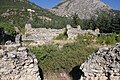
The most important ancient ruin site is Antioch in Pisidia ( Greek Αντιόχεια τὴς Πισιδίας ) near Yalvaç. The ruins of the Greco-Roman city Konana ( Greek Κωνάνα ) in Pisidia (also: Comana, Conana, Conan) can be found near Gönen . The remains of the Greco-Roman city of Adada ( Greek Ἄδαδα ) are located near the village of Sağrak in the Sütçuler district.
The castle ruins in Eğirdir and Ulurborlu date from Byzantine times.
In the Seljuk era originated among other things
- the caravanserais Eğirdir-Han in Eğirdir and Ertokuş Han near Yeşilköy in Gelendost County, both from the early 13th century.
- The Ertokus Madrasa in Atabey, a Koran school, built in the early 13th century
- in Eğirdir the oldest parts of the Taş Medrese , a Koran school from 1238.
- The hamam in Gönen, built at the beginning of the 13th century.
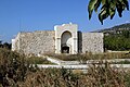
- The Kutlu Bey Cami , also: Ulu Cami (German: large mosque ) in Isparta; a mosque from 1299; Remodeling under Kutlu Bey in 1417.
- The Sefer Ağa Mosque from the 13th century in Sütçuler.
- The Alaadin Mosque in Uluborlu from 1231.
- The Balta Bey Hamam (also: Muhtesip Hamami ), a bath house, built in 1180 in Uluborlu.
At the time of the Hamidoğulları emerged among other things
- the Taş Medrese (also: Dündar Bey Madrasa ) in Eğirdir. Feleküddin Dündar had it expanded in 1301 from the stones of the former Eğirdir-Hans . It is the historically most valuable building from the Hamidoğulları era.
- The Ulu Cami (German: Great Mosque ) in Eğirdir from 1327.
- The Hızır-Bey Mosque in Isparta. It was built together with the Hızır Bey Hamam in 1327/28 under Hızır Bey, the hammam is now in ruins. The mosque was destroyed in the great earthquake in Isparta in 1888 and rebuilt after the quake.
- The Fatih Sultan Mosque from the end of the 13th century in Şarkikaraağaç.
- The 13th century Devlethan Mosque in Yalvaç.
- The Muhittin Fountain and the Arapçık Fountain in Uluborlu. They were built between 1300 and 1324, as was the Efendi Sultan Mosque.
From the Ottoman period are u. a. the following buildings are worth seeing:
- the early Ottoman Yokuşbaşı Mosque in Barla, 15th century.
- The Afşar mosque in Gelendost from the end of the 14th century.
- The Firdevs-Bey-Cami (also: Firdevs Paşa Camii , Mimar Sinan Camii ); a mosque from 1561. It and the neighboring Bedesten (German: market hall) are attributed to the architect Sinan . Badly damaged by earthquake in 1914, then renovated.
- The Merkez Cami from 1692 and the Sinan Bey Camii from the 17th century, two mosques in Keçiborlu.
Personalities
- Ramazan Avcı , murdered by neo-Nazis in Hamburg, born in Gönen and buried after his death
- Süleyman Demirel , former state and prime minister
- Mustafa Doğan , footballer
Photo gallery

Aksu with the Kuyucak Mountains.

Dipoyraz, also called Dedegöl, 2,980 m.

The Zindan Cave near Aksu.

Kızıldağ National Park near Yenişarbademli; Looking north

Lake Hoyran near Taşevi, Yalvaç County.

The Kovada Lake
Antioch in Pisidia.

Eğirdir, Byzantine-Seljuk castle
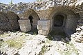
Eğirdir-Han from 1237.
Ertokuş Han from 1224.

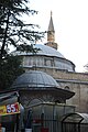
Isparta; Rose lamp in the evening with Kutlu Bey Cami.

Dündar Bey Koran School in Eğirdir.

Eğirdir, Ulu Cami ("Great Mosque"), also called Hızır Bey Camii.
The Firdevs Paşa Camii in Isparta.
.jpg)


Web links
Individual evidence
- ↑ Türkiye Nüfusu İl ve İlçelere Göre Nüfus Bilgileri , accessed on June 25, 2019
- ^ Portrait of the governor on the Isparta Province website
- ↑ http://www.isparta.gov.tr/isparta
- ↑ http://www.sutculer.gov.tr/tarihcesi
- ↑ http://www.sutculer.gov.tr/tarihcesi
- ↑ http://www.gelendost.gov.tr/tarihce
- ↑ http://www.yenisarbademli.bel.tr/sayfa/tarihcemiz.html
- ↑ Directorate General of Mapping İl ve İlçe Yüzölçümleri (PDF; 0.25 MB).
- ↑ Türkiye Nüfusu İl İlçe Mahalle Köy Nüfusu , accessed on June 25, 2019.
- ↑ illeridaresi.gov.tr (PDF; 1.4 MB).
- ↑ Genel Nüfus Sayımları (census results 1965 to 2000)
- ↑ http://www.isparta.gov.tr/kizildag-milli-parki
Adana | Adıyaman | Afyonkarahisar | Ağrı | Aksaray | Amasya | Ankara | Antalya | Ardahan | Artvin | Aydın | Balıkesir | Bartın | Batman | Bayburt | Bilecik | Bing oil | Bitlis | Bolu | Burdur | Bursa | Çanakkale | Çankırı | Çorum | Denizli | Diyarbakır | Düzce | Edirne | Elazığ | Erzincan | Erzurum | Eskişehir | Gaziantep | Giresun | Gümüşhane | Hakkâri | Hatay | Iğdır | Isparta | İstanbul | İzmir | Kahramanmaraş | Karabük | Karaman | Kars | Kastamonu | Kayseri | Kırıkkale | Kırklareli | Kırşehir | Kilis | Kocaeli | Konya | Kutahya | Malatya | Manisa | Mardin | Mersin | Muğla | Muş | Nevşehir | Niğde | Ordu | Osmaniye | Rize | Sakarya | Samsun | Siirt | Sinop | Sivas | Şanlıurfa | Şırnak | Tekirdağ | Tokat | Trabzon | Tunceli | Usak | Van | Yalova | Yozgat | Zonguldak