
Kirchlinteln
| coat of arms | Germany map | |
|---|---|---|

|
Coordinates: 52 ° 57 ' N , 9 ° 19' E |
|
| Basic data | ||
| State : | Lower Saxony | |
| County : | Verden | |
| Height : | 45 m above sea level NHN | |
| Area : | 174.17 km 2 | |
| Residents: | 9911 (Dec. 31, 2019) | |
| Population density : | 57 inhabitants per km 2 | |
| Postal code : | 27308 | |
| Primaries : | 04236, 04230 , 04231 , 04237 , 04238 | |
| License plate : | VER | |
| Community key : | 03 3 61 005 | |
| LOCODE : | DE KLN | |
| Community structure: | 17 localities | |
| Address of the municipal administration: |
Am Rathaus 1 27308 Kirchlinteln |
|
| Website : | ||
| Mayor : | Wolfgang Rodewald (independent) | |
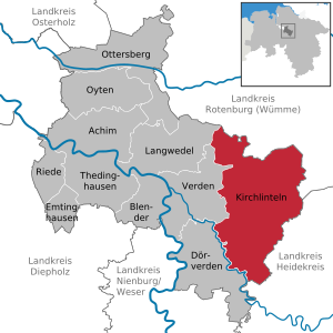
| Location of the municipality of Kirchlinteln in the district of Verden | ||
  |
||

Kirchlinteln ( Low German : Karklinteln or Kerklinteln ) is a unified municipality in the Verden district in Lower Saxony in the east of the district.
geography
Geographical location
Kirchlinteln is the largest municipality in terms of area in the district of Verden and is located in the triangle of the major cities of Bremen , Hanover and Hamburg . The 17 localities of the municipality are located in the Lintelner Geest and the adjacent area to the south called Kleinbahnwinkel up to the Aller . The Holtumer Moor belongs to the Wümmeniederung . The Lintelner Geest as part of the Achim-Verdener Geest and the Wümmeniederung are part of the natural area of the Stader Geest .
Neighboring communities
| Langwedel , Ahausen | Westerwalsede | Kirchwalsede |
| Verden (Aller) |
.svg)
|
Visselhövede |
| Dörverden | Häuslingen | Walsrode |
Community structure
|
|
These localities each have a local chief.
history
Name, first mention
Kirchlinteln: The name Lintlo for Kirchlinteln is first mentioned in 1123 in a document from Bishop Dithardus von Verden. Until the 20th century, the core town was officially called Großlinteln .
Bendingbostel was mentioned as Bostellde in 1320 in the property register of Bishop Nikolaus from 1320.
Heins: was mentioned as Berndeß-Heinße in 1320 in the property register of Bishop Nikolaus from 1320.
Hohenaverbergen , the name comes from its location on a hill.
Holtum was first mentioned in a document from Heinrich I in 935 .
Kreepen: The first documentary mention of Cregenhob (probably Kreepen) comes from the property register of Bishop Nicholas from 1320.
Kükenmoor derives its name from the Kük , the former owners of three farms.
Schafwinkel was first mentioned in a document in 1385, the district Odeweg in 1144.
Weitzmühlen was named because of a previous grain processing company.
history
Archaeological finds in the area suggest settlements from the Neolithic and Bronze Ages . The barrows of the barrow heath near Kirchlinteln date from the Bronze Age, around 2500 to 1400 years BC. Chr.
Most of the villages go back to settlements from the Middle Ages . The originally Romanesque church in Wittlohe has been mentioned in a document since 1231, but is probably older. The Kerke to Lintloh , dedicated to St. Peter - the tower of which is still standing from around 1200 - was first mentioned in 1385 in a document from the Verden bishop Johann II.
The territory of the municipality Kirchlinteln was initially part of the Duchy of Verden , which after the Thirty Years' War to Swedish territory Bremen-Verden arrived. After brief Danish rule, Kirchlinteln became part of the Electorate of Braunschweig-Lüneburg in 1715 , which became the Kingdom of Hanover after the Napoleonic Wars in 1814 . From 1866 Hanover was occupied by Prussia after the German War and remained a Prussian province until 1946 . Kirchlinteln experienced an upswing as a destination for tourism and excursion tourism with the construction of the America Line in 1874.
In 1946 Kirchlinteln became part of the re-established state of Hanover , which in the same year merged with Braunschweig , Schaumburg-Lippe and Oldenburg to form the state of Lower Saxony. After the war, many expellees from East Prussia , Pomerania , Silesia , Czechoslovakia and Bessarabia settled in the area of today's municipality.
Over time, thanks to its convenient location on Autobahn 27 and the associated short travel time to Bremen and Hanover, Kirchlinteln wins many new residents who want to live in rural areas, but who also value short commuting times to the neighboring cities.
Incorporations
As part of an administrative reform on July 1, 1972, the communities Armsen, Bendingbostel, Brunsbrock, Heins, Hohenaverbergen, Holtum (Geest), Kirchlinteln, Kreepen, Kükenmoor, Luttum, Neddenaverbergen, Otersen, Schafwinkel, Sehlingen, Stemmen, Weitzmühlen and Wittlohe in the east Verden district amalgamated to form a single community of Kirchlinteln. It was named after the largest village Kirchlinteln, in which the most important administrative offices are also based.
politics
Municipal council
The municipality council of the municipality of Kirchlinteln consists of 24 councilors (up to 2016: 26). 26 council members is the fixed number for a municipality with a population between 10,001 and 11,000 inhabitants, at the cut-off date the population of the municipality had slipped just below 10,000. The 24 council members are elected by local elections for five years each. The current term of office began on November 1, 2016 and ends on October 31, 2021.
The full-time mayor Wolfgang Rodewald (independent) is also entitled to vote in the council of the municipality.
The last local election on September 11, 2016 resulted in the following:
mayor
The full-time mayor of the Kirchlinteln community is Wolfgang Rodewald (independent). In the last mayoral election on May 25, 2014, he was re-elected as incumbent unopposed candidate with 86.5% of the vote. The turnout was 53.1%. Rodewald began his further term of office on November 1, 2014.
coat of arms
Blazon : "Split of red and gold, in front a continuous polished silver Latin high cross, behind a wheelless, blue plow."
flag
The colors of the flag are red-gold-red, topped with the coat of arms.
Partner communities
-
 Schönhausen (Elbe) , Saxony-Anhalt since 1991
 -
 Letovice , Czech Republic , since May 5, 2003. This partnership includes in particular a school partnership.
Culture and sights
Museums
Buildings
_IMG_9221.jpg)

- Church of St. Petri in Kirchlinteln (central place) from 1798, tower from the 12th century
- Church of St. Jacobi from 1894 in Wittlohe
- Capitelhaus zu Wittlohe
- Church in Brunsbrock (Independent Evangelical Lutheran Church)
- Dutch windmills in Schmomühlen (Müllerhaus cultural center) and Holtum (Geest)
- old town center in the central town of Kirchlinteln with houses z. T. from the 18th century and old granaries
- old fire station in the central village of Kirchlinteln
- All ferry in Otersen (summer season, bike transport)
- Lindhoop monument
- 202 meter high transmission mast of the German radio tower between Luttum and Weitzmühlen, at 52 ° 54'34 "north latitude and 9 ° 18'21" east longitude (transmitter Verden)
- 134 meter high telecommunications tower of the German radio tower in reinforced concrete construction near Holtum-Geest (52 ° 59'53 "north latitude and 9 ° 16'13" east longitude)
Natural monuments
- Extensive heather and geest areas in the Lintelner Geest .
- Hill grave heather near the core village of Kirchlinteln
- Hollow roads in the tumulus heather
- Brammer See
- Historic street , single-lane oak alley (Kreisstraße 12) with cobblestone pavement between the central town of Kirchlinteln and Kükenmoor
Regular events
Every year on the 3rd weekend in September, the "Lintler beet market" takes place in Kirchlinteln, a traditional festival that first took place in 1660.
On the first weekend in Advent, “The Other Christmas Market” has been established around the Kirchlinteln St. Petri Church for several years.
Economy and Transport
Companies
The agriculture plays an important role in the villages of the municipality Kirchlinteln. Furthermore is rural tourism promoted. In addition to the local handicrafts, there are some companies in vehicle and mechanical engineering as well as in the shipping industry. Kirchlinteln has branches of the Volksbank Aller-Weser eG and the Kreissparkasse Verden .
traffic
Road traffic
The municipality of Kirchlinteln is located on the A 27 Bremen – Walsrode. Although the Verden-Ost junction is in the area of the city of Verden (Aller), it can be reached very quickly from Kirchlinteln, approx. 3 km away. Landesstraße 171 (Verden – Schneverdingen) crosses the municipality from west to east and connects the villages in the Lintler Geest. In the south of the municipality, localities that were formerly on the Verden-Walsroder railway line - often referred to as "small railway district" in the vernacular - are connected by the state roads 160 and 159.
Public transport
The villages of the Kirchlinteln community are connected to Verden (Aller) by public buses. At the district boundaries there are connections to regular bus connections to Rotenburg (Wümme) and Walsrode at individual points. There is a citizen bus system within Kirchlinteln that opens up the east and south of the community. The village of Holtum (Geest) is not connected.
Rail transport
In the area of the municipality there are three railway lines of different importance. The Uelzen – Langwedel railway crosses the municipality from west to east . Next to the train station in the village of Bendingbostel, the Kirchlinteln train station had been located on the northwestern edge of the central town since 1873. Since about 1912 the place was also the seat of a railway maintenance office. The railway was thus one of the largest employers for decades. After the traffic continued to decline since the 1970s, the last passenger train left Kirchlinteln on September 26, 1987; three years later, the last freight traffic was also stopped. The remaining technical systems, which were controlled from Langwedel, have been dismantled since 2004; the station has since been definitively de-dedicated. The regional and freight trains thus cross the municipality without stopping today. The re-establishment of a stop in Kirchlinteln is currently planned.
In the south of the municipality there has been the so-called small railway line of the Verden-Walsroder Railway since 1911 , which today ends in Stemmen. It is only occasionally used for freight transport and as a museum railway . The single-track, now electrified Verden – Rotenburg ( Weser-Aller-Bahn ) line has been in the northwest of the municipality since 1928 ; In the village of Holtum (Geest) there is a train station , which is no longer used for passenger traffic, but is remotely controlled from Verden as an alternative point .
The nearest train stations for passenger transport are in Verden (Aller) , Visselhövede and Langwedel .
Long-distance cycle path
In Verdenermoor the cat and in Ramelsen the rooster are said to have joined the other “ Bremen Town Musicians ”. A long-distance cycle path connects all four places where the four animals are said to have lived and the robber's house in Horst, which is also in the area of the municipality of Kirchlinteln. This cycle path, known as the “Town Musicians Path”, was inaugurated in 2008.
Infrastructure
Public facilities
- Town hall in Kirchlinteln.
- Community and school library in Kirchlinteln.
- Kirchlinteln volunteer fire brigade with 14 locations
Social facilities
- Seven kindergartens and day-care centers in Bendingbostel, Holtum (Geest), Kirchlinteln, Luttum, Neddenaverbergen and Otersen.
- The youth rooms of the community in Kirchlinteln are administered by the youth themselves.
- Multi-generation place in Hohenaverbergen
- Forest playground in Kirchlinteln and "Moorkieker" adventure playground in Kükenmoor
- Eichenhof nursing home
- In the core town of Kirchlinteln there are two general practitioners' practices and two dental practices. Another general practice and a dental practice are located in the village of Luttum. There is also a pharmacy and practices for physiotherapy in Kirchlinteln.
- The closest hospitals are the Aller-Weser-Klinik in Verden in six kilometers , and the Aller-Weser-Klinik in Achim near Bremen, the Agaplesion Diakonieklinikum Rotenburg and the Heidekreis-Klinikum in Walsrode in about 25 kilometers . In the emergency medical service , Kirchlinteln is looked after by the on-call practice of the Association of Statutory Health Insurance Physicians located in the Verden hospital.
education
- Lintler Geest School in Bendingbostel, a primary school.
- Luttum primary school in Luttum.
- School at Lindhoop in Kirchlinteln, until 2012 a secondary and secondary school as an all-day school and has been a secondary school since 2012 .
Churches
- Evangelical Lutheran St. Petri Church in Kirchlinteln
- Ev.-luth. St. Jakobi Church in Wittlohe
- St. Matthew Congregation in Brunsbrock of the Independent Evangelical Lutheran Church (SELK).
- Catholic Propsteigemeinde in Verden.
- Furthermore: Jehovah's Witnesses , Orthodox Christians , Baptists , members of free churches and members of Islam ; mostly organized in the district town of Verden. There is a congregation of the Christadelphians in Bendingbostel .
literature
- Robert Kienzle: Chronicle Kirchlinteln. 1969
- Günter Lühning u. Hermann Meisloh: Kirchlinteln and its 17 districts. 1983
- Hermann Meisloh: Games from history - Linteln ... and a lot more - in hoch un platt 2011
- further village chronicles from the Kirchlinteln community
- Armsen 1991 (Jürgen Siemers)
- Brunsbrock 1956 (Robert Kienzle)
- Hohenaverbergen 2008 (Lydia Niehoff)
- Holtum Geest 1991 (extended new edition 2 parts 2008) (H. Lübbers)
- Big and Small Heins 2001 (Willi Bunke)
- Kreepen / Brammer 1998 (Udo Friday)
- Luttum 1997 (Village Chronicle Working Group, H.Meyer)
- Neddenaverbergen 1987 (working group and Jürgen Siemers)
- Neddenaverbergen 2003 (Part 2) (Working group, K. Tietje / Petra Rübke)
- Otersen 1994 (Hermann Dreyer)
- Wittlohe-Stemmen 2000 (village group / Alfred Lührs)
Web links
Individual evidence
- ↑ State Office for Statistics Lower Saxony, LSN-Online regional database, Table 12411: Update of the population, as of December 31, 2019 ( help ).
- ^ Federal Statistical Office (ed.): Historical municipality directory for the Federal Republic of Germany. Name, border and key number changes in municipalities, counties and administrative districts from May 27, 1970 to December 31, 1982 . W. Kohlhammer GmbH, Stuttgart / Mainz 1983, ISBN 3-17-003263-1 , p. 248 .
- ^ Lower Saxony Municipal Constitutional Law (NKomVG) in the version of December 17, 2010; Section 46 - Number of MPs , accessed on December 1, 2014
- ↑ Individual results of the direct elections on May 25, 2014 in Lower Saxony ( Memento of the original from March 3, 2016 in the Internet Archive ) Info: The archive link was inserted automatically and has not yet been checked. Please check the original and archive link according to the instructions and then remove this notice. , accessed December 1, 2014
- ↑ Reopening of the train station
- ↑ Klaus Merkle: The story about the presumed origin of the town musicians ( Memento from September 12, 2012 in the web archive archive.today )
- ^ Verden district: Town Musicians Way
Cities: Achim | Verden (Aller)
Other municipalities: Blender | Dörverden | Emtinghausen | Kirchlinteln | Long tail | Ottersberg | Oyten | Vineyard | Thedinghausen