La Chapelle-Palluau
| La Chapelle-Palluau | ||
|---|---|---|
|
|
||
| region | Pays de la Loire | |
| Department | Vendée | |
| Arrondissement | La Roche-sur-Yon | |
| Canton | Challans | |
| Community association | Vie et Boulogne | |
| Coordinates | 46 ° 47 ′ N , 1 ° 37 ′ W | |
| height | 11-64 m | |
| surface | 13.01 km 2 | |
| Residents | 946 (January 1, 2017) | |
| Population density | 73 inhabitants / km 2 | |
| Post Code | 85670 | |
| INSEE code | 85055 | |
| Website | http://www.lachapellepalluau.fr/ | |
La Chapelle-Palluau is a municipality with 946 inhabitants (as of January 1, 2017) in the western French department of Vendée in the southwest of the Pays de la Loire region . The municipality belongs to the arrondissement of La Roche-sur-Yon and the canton of Challans (until 2015: canton Palluau ). The inhabitants are called chapellois .
location
La Chapelle-Palluau is located about 17 kilometers northwest of La Roche-sur-Yon . The river Vie borders the community in the south. The Petite Boulogne flows along the northern municipal boundary . La Chapelle-Palluau is surrounded by the neighboring communities Palluau in the north, Le Poiré-sur-Vie in the east and southeast, Aizenay in the south, Maché in the southwest and Saint-Paul-Mont-Penit in the west.
history
From 1972 to 1979 La Chapelle-Palluau was part of the municipality of Aizenay .
Population development
| year | 1793 | 1851 | 1901 | 1954 | 1962 | 1968 | 1975 | 1982 | 1990 | 1999 | 2006 | 2013 |
| Residents | 1,000 | 1,068 | 939 | 726 | 719 | 684 | - | 618 | 647 | 686 | 826 | 928 |
| Source: Cassini and INSEE | ||||||||||||
Attractions
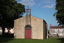
- Notre-Dame de Miséricorde chapel
literature
- Le Patrimoine des Communes de la Vendée. Flohic Editions, Volume 2, Paris 2001, ISBN 2-84234-118-X , pp. 701-704.

