Saint-Martin-des-Noyers
| Saint-Martin-des-Noyers | ||
|---|---|---|

|
|
|
| region | Pays de la Loire | |
| Department | Vendée | |
| Arrondissement | La Roche-sur-Yon | |
| Canton | Chantonnay | |
| Community association | Pays de Chantonnay | |
| Coordinates | 46 ° 43 ′ N , 1 ° 11 ′ W | |
| height | 58-118 m | |
| surface | 41.74 km 2 | |
| Residents | 2,372 (January 1, 2017) | |
| Population density | 57 inhabitants / km 2 | |
| Post Code | 85140 | |
| INSEE code | 85246 | |
| Website | http://www.saintmartindesnoyers.fr/ | |
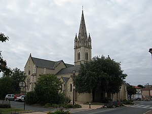
 Saint Martin Church |
||
Saint-Martin-des-Noyers is a French municipality with 2372 inhabitants (as of January 1 2017) in the department of Vendée in the region of Pays de la Loire ; it belongs to the arrondissement of La Roche-sur-Yon and the canton of Chantonnay (until 2015: canton Les Essarts ). The inhabitants are called Martinoyens .
geography
Saint-Martin-des-Noyers is located about 62 kilometers south-southeast of Nantes . The sources of the rivers Yon and Boulogne are in the municipality . Saint-Martin-des-Noyers is surrounded by the neighboring communities of Les Essarts in the north and north-west, Sainte-Cécile in the east and north-east, Saint-Hilaire-le-Vouhis in the south and south-east, Fougeré in the south and south-west, La Chaize-le- Viscount in the southwest, La Ferrière in the west and La Merlatière in the northwest. The A83 autoroute runs through the municipality .
Residents
| year | 1946 | 1954 | 1962 | 1968 | 1975 | 1982 | 1990 | 1999 | 2006 | 2012 |
|---|---|---|---|---|---|---|---|---|---|---|
| Residents | 1,700 | 1,775 | 1,671 | 1,655 | 1,769 | 1,867 | 1.953 | 2.003 | 2.152 | 2,254 |
Attractions
- La Grève Castle, monument historique since 1984
- Saint Martin Church
Personalities
- René Couzinet (1904–1956), aircraft designer
literature
- Le Patrimoine des Communes de la Vendée. Flohic Editions, Volume 1, Paris 2001, ISBN 2-84234-118-X , pp. 234-237.

