
Mesnard-la-Barotière
| Mesnard-la-Barotière | ||
|---|---|---|
.svg)
|
|
|
| region | Pays de la Loire | |
| Department | Vendée | |
| Arrondissement | La Roche-sur-Yon | |
| Canton | Montaigu | |
| Community association | Pays des Herbiers | |
| Coordinates | 46 ° 52 ′ N , 1 ° 6 ′ W | |
| height | 73-109 m | |
| surface | 11.83 km 2 | |
| Residents | 1,440 (January 1, 2017) | |
| Population density | 122 inhabitants / km 2 | |
| Post Code | 85500 | |
| INSEE code | 85144 | |
| Website | http://www.mesnard-la-barotiere.fr/ | |
 Town hall (Mairie) of Mesnard-la-Barotière |
||

Mesnard-la-Barotière is a French village with 1,440 inhabitants (as of January 1 2017) in Vendée in the region of Pays de la Loire ; it belongs to the arrondissement of La Roche-sur-Yon and the canton of Montaigu (until 2015: canton of Les Herbiers ). The inhabitants are called Mesnardais .
Neighboring communities
Mesnard-la-Barotière is located about 32 kilometers northeast of La Roche-sur-Yon . Mesnard-la-Barotière is surrounded by the neighboring communities of Saint-Fulgent in the north and west, Les Herbiers in the north and east and Vendrennes in the south.
Population development
| year | 1962 | 1968 | 1975 | 1982 | 1990 | 1999 | 2006 | 2013 |
| Residents | 650 | 641 | 672 | 815 | 901 | 891 | 1,163 | 1,325 |
| Source: Cassini and INSEE | ||||||||
Attractions
See also: List of Monuments historiques in Mesnard-la-Barotière
- Old Saint-Christophe church from the 11th century with remodeling from the 13th century
- Notre-Dame church
- Old castle with chapel from the 16th century, monument historique since 1987
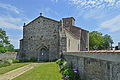
Saint-Christophe Church
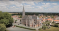
Notre-Dame church


literature
- Le Patrimoine des Communes de la Vendée. Flohic Editions, Volume 1, Paris 2001, ISBN 2-84234-118-X , pp. 329-333.
Web links
Commons : Mesnard-la-Barotière - Collection of images, videos and audio files