Pennington County, South Dakota
 Pennington County Courthouse |
|
| administration | |
|---|---|
| US state : | South Dakota |
| Administrative headquarters : | Rapid City |
| Address of the administrative headquarters: |
Pennington County Courthouse 315 Saint Joseph Street Rapid City, SD 57701101 E |
| Foundation : | 1875 |
| Demographics | |
| Residents : | 100,948 (2010) |
| Population density : | 14 inhabitants / km 2 |
| geography | |
| Total area : | 7211 km² |
| Water surface : | 21 km² |
| map | |
| Website : www.co.pennington.sd.us | |
Pennington County is a county in the state of South Dakota in the United States . In 2010 the population was 100,948. The county seat is Rapid City , the second largest city in South Dakota.
history
Pennington County was incorporated on January 11, 1875, and finally organized on April 19, 1877. It is named after John L. Pennington , the then governor of the Dakota Territory .
Two places in the county are of outstanding historical importance: the Minuteman Missile National Historic Site and the Mount Rushmore National Memorial . 59 buildings and sites in the county are listed on the National Register of Historic Places (NRHP) (as of July 29, 2018).
geography

The area of the county is 7211 square kilometers. Of this, 21 square kilometers (0.29 percent) are water. The county is bordered by other counties in a clockwise direction: Meade County , Haakon County , Jackson County , Oglala Lakota County , Custer County , Weston County in Wyoming, and Lawrence County .
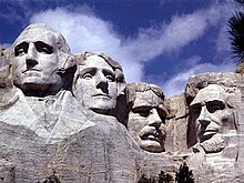
Mount Rushmore is in the county area . Images of the heads of four US presidents were carved into this mountain . Also, the Harney Peak , the highest mountain in South Dakotas , located in Pennington County.
Population development
| Population development | |||
|---|---|---|---|
| Census | Residents | ± in% | |
| 1900 | 5610 | - | |
| 1910 | 12,453 | 122% | |
| 1920 | 12,720 | 2.1% | |
| 1930 | 20,079 | 57.9% | |
| 1940 | 23,799 | 18.5% | |
| 1950 | 34,053 | 43.1% | |
| 1960 | 58.195 | 70.9% | |
| 1970 | 59,349 | 2% | |
| 1980 | 70,361 | 18.6% | |
| 1990 | 81,343 | 15.6% | |
| 2000 | 88,565 | 8.9% | |
| 2010 | 100,948 | 14% | |
| 1900-1990
2000 |
|||
cities and communes
Cities ( cities )
Communities ( towns )
Townships
The county is divided into 20 townships : Ash, Castle Butte, Cedar Butte, Conata, Crooked Creed, Fairview, Flat Butte, Huron, Imlay, Lake Creek, Lake Flat, Lake Hill, Owanka, Peno, Quinn, Rainy Creek / Cheyenne, Scenic, Shyne, Sunnyside, and Wasta; and seven disorganized territories: Central Pennington, Dalzell Canyon, East Central Pennington, Mount Rushmore, Northeast Pennington, Rapid City East, and West Pennington.
Web links
Individual evidence
- ^ Pennington County in the United States Geological Survey's Geographic Names Information System . Retrieved February 22, 2011
- ↑ Charles Curry Aiken, Joseph Nathan Kane: The American Counties: Origins of County Names, Dates of Creation, Area, and Population Data, 1950-2010 . 6th edition. Scarecrow Press, Lanham 2013, ISBN 978-0-8108-8762-6 , p. 238 .
- ↑ Listing of National Historic Landmarks by State: South Dakota . National Park Service , accessed July 28, 2018.
- ↑ Search mask database in the National Register Information System. National Park Service , accessed July 29, 2018.
- ↑ Extract from Census.gov . Retrieved February 28, 2011
- ↑ Excerpt from factfinder.census.gov.Retrieved February 28, 2011
Coordinates: 44 ° 1 ′ N , 102 ° 49 ′ W
