Rosenthal (Odenthal)
|
Rosenthal
Odenthal municipality
Coordinates: 51 ° 0 ′ 52 ″ N , 7 ° 10 ′ 35 ″ E
|
||
|---|---|---|
|
Location of Rosenthal in Odenthal |
||
|
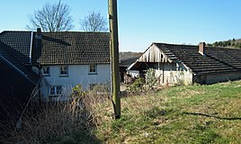
The Rosenthaler Hof near Altehufe
|
||
Rosenthal is a district in the municipality of Odenthal in the Rheinisch-Bergisches Kreis .
history
Hof Rosenthal is mentioned in the original cadastre northeast of Hof Büchel . It is a late medieval settlement. It was first mentioned in 1400 as Rosendael . In the 15./16. In the 19th century, the farm must have come into the possession of the Johanniterkommende Herrenstrunden , as it is already listed in a lease from 1600. The stock book of the commander of 1732 mentions the size of the farm with 113.5 acres of land , about half of which was arable land and half of it was forest. After the secularization in 1806, the farm was initially no longer managed and threatened to deteriorate. Only in the middle of the 19th century were all the buildings gradually renewed. At the same time the agricultural operation was resumed. After the parish of Herrenstrunden looked after the farm from 1918, a connecting path - the Rosenthaler Weg - was laid between the farm and the parish in 1929.
Individual evidence
- ^ Andree Schulte, Bergisch Gladbach, city history in street names , published by the Bergisch Gladbach city archive, volume 3, and by the Bergisches Geschichtsverein department Rhein-Berg e. V., Volume 11, Bergisch Gladbach 1995, p. 190, ISBN 3-9804448-0-5

