
Oberborsbach
|
Oberborsbach
Odenthal municipality
Coordinates: 51 ° 1 ′ 0 ″ N , 7 ° 8 ′ 14 ″ E
|
||
|---|---|---|
| Postal code : | 51519 | |
Location of Oberborsbach in Odenthal |
||
 Borsbacher Hof in Oberborsbach
|
||

Oberborsbach is a residential area in Oberodenthal in the municipality of Odenthal in the Rheinisch-Bergisches Kreis .
Location and description
Oberborsbach is located in the south of the municipality on the border with Bergisch Gladbach .
history
A tax list from 1586 shows that Borsbach was part of the Scherf family in the Odenthal parish. The Topographia Ducatus Montani by Erich Philipp Ploennies , Blatt Amt Miselohe , proves that the residential area was categorized as Freyhof in 1715 and named Böschbach .
Carl Friedrich von Wiebeking names the court on his charter of the Duchy of Berg in 1789 as Borsbach . It emerges from it that Borsbach was part of the Odenthal rule in the Bergisch Amt Porz at that time .
Under the French administration between 1806 and 1813, the Porz office was dissolved. From then on there was a Borsbach in the mayor's office of Odenthal in the Mülheim am Rhein district, formed by the Prussians in 1816, and a Borsbach in the mayor's office of Gladbach .
The place is recorded on the topographical survey of the Rhineland from 1824 as Borsbach and on the Prussian first survey of 1840 as Borsbach . From the Prussian new admission in 1892, it is regularly recorded on the measuring table as Borsbach or without a name.
Today Borsbach (Odenthal) is called Oberborsbach and Borsbach (Bergisch Gladbach) is called Unterboschbach . Oberborsbach belongs to the Catholic parish Odenthal.
| year | Residents | Residential buildings | category |
|---|---|---|---|
| 1822 | 20th | Arable land | |
| 1830 | 30th | Arable land | |
| 1845 | 21st | 3 | Arable land |
| 1871 | 19th | 4th | Yard |
| 1885 | 33 | 4th | Locality |
| 1895 | 31 | 4th | Locality |
| 1905 | 26th | 4th | Locality |
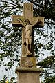
monument
In front of the farm in Oberborsbach there is a road cross from 1790, which is entered in the list of architectural monuments in Odenthal with the number 3.

Monument in Oberborsbach
detail
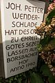
detail
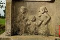
detail


Individual evidence
- ↑ Gerd Müller: Odenthal, History of a Bergische Gemeinde, published by the municipality of Odenthal, Odenthal 1976
- ^ Wilhelm Fabricius : Explanations for the Historical Atlas of the Rhine Province ; Second volume: The map of 1789. Division and development of the territories from 1600 to 1794 ; Bonn; 1898
- ↑ Alexander A. Mützell: New topographical-statistical-geographical dictionary of the Prussian state . tape 1 . Karl August Künnel, Halle 1821.
- ↑ Friedrich von Restorff : Topographical-statistical description of the Royal Prussian Rhine Province , Nicolai, Berlin and Stettin 1830
- ↑ Overview of the components and list of all the localities and individually named properties of the government district of Cologne: by districts, mayor's offices and parishes, with information on the number of people and the residential buildings, as well as the Confessions, Jurisdictions, Military and former state conditions. / ed. from the Royal Government of Cologne [Cologne], [1845]
- ↑ Royal Statistical Bureau Prussia (ed.): The communities and manor districts of the Prussian state and their population . The Rhine Province, No. XI . Berlin 1874.
- ↑ Königliches Statistisches Bureau (Prussia) (Ed.): Community encyclopedia for the Rhineland Province, based on the materials of the census of December 1, 1885 and other official sources, (Community encyclopedia for the Kingdom of Prussia, Volume XII), Berlin 1888.
- ↑ Königliches Statistisches Bureau (Prussia) (Ed.): Community encyclopedia for the Rhineland Province, based on the materials of the census of December 1, 1895 and other official sources, (Community encyclopedia for the Kingdom of Prussia, Volume XII), Berlin 1897.
- ↑ Königliches Statistisches Bureau (Prussia) (Ed.): Community encyclopedia for the Rhineland Province, based on the materials of the census of December 1, 1905 and other official sources, (Community encyclopedia for the Kingdom of Prussia, Issue XII), Berlin 1909.
Old hooves | Altenberg | Amtmannscherf | Aue | Blecher | Bömberg | Bömerich | Bömericher Mühle | Bean | Book Mill | Bülsberg | Bush | Dülmen | Dünnerhöfe | March through | Eichholz | Eikamp | Erberich | Farzemich | Field | Field house | Funkenhof | Glöbusch | Grimberg | Großeheide | Grossgrimberg | Grand Specard | Green sapling | Hahnenberg | Heidberg | Heather | Heiderhof | Helenenthal | Herzogenhof | Hochscherf | Farm | Height | Hohenfeld | Hollandsmühle | Hollweg | Wood | Hut | Hunger | Young wood | Klasmühle | Klev | Cooking court | Koenigsberg | Kingdom | Kragau | Kramerhof | Küchenberg | Kümps | Course depths | Landwehr | Lanzemich | Lengsberg | Leye | Liesenberger Mill | Meegen | Menrath | Pack | Meutemühle | Mutz | Neschen | Niederscherf | Emergency houses | Walnut | Oberbech | Oberborsbach | Oberbreidbach | Oberhortenbach | Oberkäsbach | Oberkirsbach | Oberschallemich | Oberscheid | Osenau | Pastorate | Pistershausen | Porzberg | Rosau | Rosenthal | Schallemich | Scherf | Scheuren | Schickberg | Schlinghofen | Schöllerhof | Smooth | Nice view | Schwarzbroich | Selbach | Stone | Stone house | Streets (Oberodenthal) | Streets (Unterodenthal) | Straßerhof | Strauweiler | Telegraph | Tempelhof | Trienhaus | Lower plate | Unterbreidbach | Unterkirsbach | Voiswinkel | Widdenhof | Wiebershausen | Wingensiefen | Winkelhausen | Host special
Parts of the municipality: Oberodenthal | Unterodenthal
Deserted districts: Burgwinkel | Dhün | Hasselsiefen | Hombach | Klauberg | Neuenhof | Niederkäsbach | Specarder Mill | Stems | Stragholz | Bustard | Unterhortenbach | cell