Mayorry Odenthal
The mayor Odenthal was one of nine mayors in the district Mülheim on the Rhine in Cologne Region in the Prussian Rhine Province . It was created in 1816 from the Mairie Odenthal , which was built by the French in the Grand Duchy of Berg , which in turn emerged from the lordship of Odenthal .
With the Prussian law regulating various points of the municipal constitutional law of December 27, 1927, the mayor's offices were finally abolished and the mayor's offices became the Odenthal office .
location
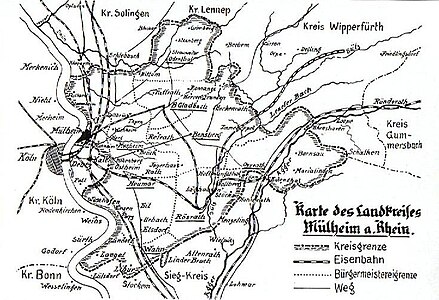
The mayor's office was in the northeast of the district. In the north it bordered the district of Lennep and, further clockwise, the district of Wipperfürth , the mayor's office of Gladbach and the district of Solingen. The size in 1920 was 4,111 ha .
Infrastructure
As a national road, there was the provincial road of the small forest to Dabringhausen . There were post offices in Odenthal and Altenberg .
mayor
The following worked as mayors in Odenthal:
- 1816-1854 PJ Fritzen
- 1854–1906 Hubert Drecker
- 1907–1909 Joseph Clewer
- 1909–1923 Karl Stausberg
- from 1924 Joseph Brochhagen
Municipalities and localities
1828 belonged to the mayor's total 4,043 residents in two villages , 28 farms and 122 agricultural goods with two churches, 531 private homes, five mills, 407 barns and stables.
In detail:
The villages of Oberodenthal and Unterodenthal or Odenthal with a parish church, a wool spinning mill and strong beekeeping, the Cistercian Abbey Altenberg , which was classified as arable property and in which a cloth factory was operated at that time, the castle houses Strauweiler and Scherf (today Amtmannscherf ), the arable goods Altehufe , Biese , Blecher , Bömberg , Bohn , Bömerich , Borsbach , ( Lower and Upper ) Breidbach, Groß-Kalmünten (today Kalmünten), Buchmühle , Burgwinkel , Busch , Buschhorn , Dorf, Duhn, Kalmünten (now Broiskalmünten ), Klasmühle , Kursiefen , Dülmen , Dünne , Fahn , Eichholz , Eikamp , Erberich , Farzemich , Feld , Großeheide , Glöbusch , Grimberg , Heidberg , Heide , Höhe , Höffe , Hochscherf , Hunger , Hüttchen , Keffermich , ( lower and upper ) Kirsbach, Königsberg , Kingdom , Küchenberg , Kümps , Landwehr , Lanzemich , Leye , Menrath , Meute , Oberbech , Oberkäsbach , Oberscheid , Osenau , pastorate , Pistershausen , Rothbroich , Scherf , Schallemich , Scheid (now Under Scheid ) Scheuren , Schick Mountain , Schildgen , Schlinghofen , Schmeisig , Black Broich , Selbach , Spezard (also Wirtsspezard ) Stragholz (also Strachelshausen), streets , roads , Trappe , Unterbech , sub Hort Bach , Voiswinkel , Wibershausen , Wingensiefen , Winkelhausen and Cell, the farms Bülsberg , Großgrimberg , Großspezard , Hahnenberg , Herzogenhof , Heiderhof , Klauberg , Kochshof , Kram , Lengsberg , Meigen , Mutz , Neschen , Niederscherf , Oberhortenbach , Nittum , Nothausen , Porzberg , Steinhaus , Strünken , Widdenhof , the mills Funkenhof , Holland , Scharrenberg (with the hover mill ) and Stein .
Around 1920, in addition to the above-mentioned towns, the mayor's office included the following places:
Aue , Dhün , Grünenbäumchen , Helenenthal , Hohenfeld , Hollweg , Hoverhof , Jungholz , Klev , Kramerhof , Neuemühle, Nothausen , Rosau , Schöne Aussicht , Spezarder Mühle , Straßerhof and Telegraph .
literature
- Johann Bendel: Homeland book of the district of Mülheim am Rhein. History and description, sagas and tales . Facsimile print of the 2nd and 3rd edition Cologne-Mülheim 1925. Cologne 1981. ISBN 3-921232-05-8
Individual evidence
- ^ Friedrich von Restorff: Topographical-statistical description of the Royal Prussian Rhine Provinces , Berlin and Stettin, 1830
- ↑ A part of Eikamp belonged to the mayor's office in Kürten .

