Pastorate (Odenthal)
|
Pastorate
Odenthal municipality
Coordinates: 51 ° 2 ′ 7 ″ N , 7 ° 7 ′ 5 ″ E
|
||
|---|---|---|
| Postal code : | 51519 | |
|
Location of pastorate in Odenthal |
||
|
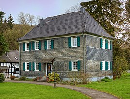
The pastorate in Odenthal
|
||
The pastorate is a listed residential building and a residential area in Unterodenthal in the municipality of Odenthal in the Rheinisch-Bergisches Kreis .
Location and description
The pastorate is part of a vicarage and is located approx. 220 m north of the Odenthal parish church between Dhünn and Altenberger-Dom-Straße. The rectory with the outbuildings and former stables is entered as a rectory ensemble under No. 25 in the list of architectural monuments in Odenthal . Today's pastorate was built in 1725 and renovated in 1976/1977.
history
In the Middle Ages and up to the modern age, it was common for pastors to get self-sufficiency in addition to the rectory as well as agricultural property, the rectory or Wiedenhof , which they could manage or lease themselves, as was the case in Odenthal. The lands of the Wiedenhof were much more extensive than they are today.
The Topographia Ducatus Montani by Erich Philipp Ploennies , Blatt Amt Miselohe , proves that the residential area was categorized as a courtyard in 1715 and was designated as pastorate . The pastorate was part of the village honors in Unterodenthal in the Middle Ages . Later it became part of the Prussian mayor's office in Odenthal . The place is regularly listed without a name on the topographical survey of the Rhineland from 1824, on the Prussian first survey from 1840 and from the Prussian new survey from 1892 on .
| year | Residents | Residential building |
category | Political / Church affiliation |
|---|---|---|---|---|
| 1822 | 4th | Arable land | Odenthal mayor's office, parish of Odenthal | |
| 1830 | 6th | Arable land | Odenthal mayor's office, parish of Odenthal | |
| 1845 | 4th | 1 | Parish apartment | Mayor's office Odenthal, parish Odenthal, called Pastorath |
The Widdenhof
The Widdenhof (Wiedenhof) as a vicarage was also registered as an independent living space during the time of the mayor's office in Odenthal.
| year | Residents | Residential building |
category | Political / Church affiliation |
|---|---|---|---|---|
| 1822 | 10 | court | Odenthal mayor's office, parish of Odenthal | |
| 1830 | 14th | court | Odenthal mayor's office, parish of Odenthal | |
| 1845 | 7th | 1 | Arable land | Odenthal mayor's office, parish of Odenthal |
Individual evidence
- ↑ Parish of St. Pankratius Odenthal - Altenberger-Dom-Straße 51 - 51519 Odenthal. Retrieved January 26, 2019 .
- ↑ a b Alexander A. Mützell: New topographical-statistical-geographical dictionary of the Prussian state . tape 1 . Karl August Künnel, Halle 1821.
- ^ A b Friedrich von Restorff : Topographical-statistical description of the Royal Prussian Rhine Province , Nicolai, Berlin and Stettin 1830
- ↑ a b Overview of the components and list of all the localities and individually named properties of the government district of Cologne: according to districts, mayorships and parishes, with information on the number of people and the residential buildings, as well as the Confessions, Jurisdictions, Military and former State Conditions. / ed. from the Royal Government of Cologne [Cologne], [1845]

