
Sölden (Ötztal)
|
Soelden
|
||
|---|---|---|
| coat of arms | Austria map | |
 |
|
|
| Basic data | ||
| Country: | Austria | |
| State : | Tyrol | |
| Political District : | Imst | |
| License plate : | IN THE | |
| Surface: | 466.78 km² | |
| Coordinates : | 46 ° 58 ′ N , 11 ° 0 ′ E | |
| Height : | 1368 m above sea level A. | |
| Residents : | 3,041 (January 1, 2020) | |
| Population density : | 6.5 inhabitants per km² | |
| Postal code : | 6450 | |
| Area code : | 05254 | |
| Community code : | 7 02 20 | |
| NUTS region | AT334 | |
| Address of the municipal administration: |
Gemeindestraße 1 6450 Sölden |
|
| Website: | ||
| politics | ||
| Mayor : | Ernst Georg Schöpf (list with Ernst Schöpf) | |
|
Municipal Council : (2016) (15 members) |
||
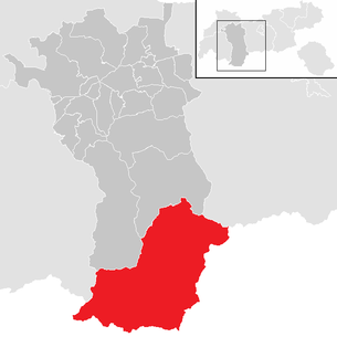
| Location of Sölden in the Imst district | ||
  |
||
 Sölden to the south with the Nederkogel |
||
| Source: Municipal data from Statistics Austria | ||

Sölden is the largest municipality in Austria , with an area of 468 km² and 3041 inhabitants (as of January 1, 2020) in the southern part of the Ötztal in the Imst district ( Silz judicial district ), Tyrol . Sölden is at an altitude of 1368 m above sea level. A.
With almost two million overnight stays per year and 15,000 guest beds, Sölden is an important tourist area, mainly for winter sports. The former character of a mountain farming village, which was dominant in the whole of Ötztal until the second half of the 20th century, was lost and was replaced by a tourist-alpine architectural style.
geography
With 468 km² Sölden is the largest municipality in Austria in terms of area . The municipality extends from the green expanse of the fourth Ötztal level to the high watershed in the south, which forms the state border with Italy ( South Tyrol ). 146 km² are covered by glaciers, 321 km² by peaks, alpine pastures and forests, and only about 1 km² are built-up areas.
Community structure
The municipality includes the following five localities (residents as of January 1, 2020):
- Gurgl (452)
- Holy Cross (123)
- Solden (2172)
- Vent (136)
- Zwieselstein (158)
The municipality consists of the only cadastral municipality of the same name, Sölden.
|
structure
|
||||||
|
Legend for the breakdown table
|
Neighboring communities
Five of the nine neighboring municipalities are in South Tyrol, two in the Imst district and one each in the Innsbruck-Land and Landeck districts.
| St. Leonhard in the Pitztal | Längenfeld | Neustift im Stubaital (IL) |
| Kaunertal (LA) |
.svg)
|
Ratschings |
|
Graun im Vinschgau Malles |
Schnals |
Moos in Passeier |
Localities of the municipality
Soelden


The formerly small Sölden has grown together with the other hamlets to form a street village, with hotels , restaurants and pensions here also being the tourist center of the community.
The cable car to the Gaislachkogel starts in the south of Sölden up to an altitude of 3,058 m . The 13 km long Ötztaler Gletscherstraße branches off from the Pitze district of Mercen to the Rettenbachferner ski areas and via the highest tunnel in the Alps to the Tiefenbachferner.
Above the valley lies at about 2083 m above sea level. A. The Hochsölden hotel complex is connected to the valley by a road and a cable car. The Giggijoch ski area is located above Hochsölden. The Berghof is at an altitude of 1435 m above sea level. A. north of the Rettenbach, directly above the center of Sölden.
Gurgl
At the end of the Gurgler Valley lies Obergurgl , at 1930 m Austria's highest church village and, like the Hochgurgl hotel complex , an important winter sports area (altitude of the ski area from 1800 m to 3080 m ). Obergurgl is the location of the University Center Obergurgl, a conference and event center of the University of Innsbruck .
The emergency landing of the stratospheric balloon of the Swiss physicist and researcher Auguste Piccard on May 27, 1931 on the Gurgler Ferner made Obergurgl more famous . In honor of Piccard, a memorial was erected in Obergurgl in 1989 to commemorate this landing.
Hochgurgl at 2150 m above sea level is a hotel complex on the road to Timmelsjoch . The Hochgurgl ski area is connected to that in Obergurgl by a cable car. From the highest point of the ski area, the 3,082 m high Wurmkogel , you have a comprehensive view of the mountains of North and South Tyrol.
Holy Cross
Heiligkreuz at 1712 m above sea level A. consists of several groups of houses spread over 8 km in the Venter Valley . Since 1956 the road connection to Vent has been continuously expanded and secured with avalanche protection galleries. In contrast to the other districts of Sölden, Heiligkreuz is not very touristy.
Vent
The district of Vent is at an altitude of 1895 m above sea level. A. at the end of the Vent Valley.
Zwieselstein
At Zwieselstein , the rear Ötztal divides into the Venter and Gurgler valley . This place has partly preserved its village character with old wooden houses. Zwieselstein was first mentioned in a document as Twiselsteyn in 1269. The place is also known as a stage destination of the European long-distance hiking trail E5, which was opened in 1972 .
Population development

history


The high alpine pastures of the rearmost Innerötztal were visited by hunters and shepherds as early as the Stone Age, as the discovery of Ötzi showed. They came from the south over the main Alpine ridge and began around 4500 BC. To enlarge the usable pastureland by slash and burn at the tree line. The Innerötztal was originally only used as an alpine pasture from the Vinschgau . The gradual settlement activity from the south shaped numerous Rhaeto-Romanic place names, especially in the Venter Valley , and Romanesque expressions have been preserved in the Innerötztal dialect to this day.
The place name Sölden is derived from "selda", which means something like the smallest farm size. Sölden is mentioned for the first time in 1166/67 in the chronicle of the Ottobeuren monastery as "Seldon", when two Schwaigen were bequeathed to the monastery . In the course of the labialization , the “e” in the word Sölden later changed to an “ö”.
Today's Sölden has developed from the original farms Berghof , Haimbach, Kaisers, Leite, Lochlehn, Pitze, Rechenau, Rettenbach, Schmiedhof, Wald, Windau and Wohlfahrt. These Urhöfe were first mentioned in a document from 1288 to approx. 1370 AD.
In 1811 Sölden formed one of ten lawyers at the Petersberg Court , which was declared a political municipality in 1817. 1854 was the village of Vent, to 1826 to court Kastelbell belonging Venosta, incorporated. In 1923 the remaining part of the municipality of Schnals came to the municipality of Sölden.
Until the gradual beginning of tourism, the livelihood of the residents was mainly cattle breeding and trade via the Timmelsjoch and the Hochjoch.
Sölden, Gurgl and Vent were raised to independent parishes in 1891.
In the middle of the 19th century, the building of shelters and paths, supported by the "Glacier Pastor" Franz Senn , led to the first tourist development. The expansion into a winter sports center began in 1948 with the first lifts, which were followed by the Rettenbach and Tiefenbach glacier in 1975 and 1981.
Sölden cable car accident
On September 5, 2005 at around 1 p.m., a helicopter flew over the Schwarze-Schneid 1 cable car, which was in operation, when metal abrasion particles triggered a short circuit in the load-shedding switch of the aircraft, which opened the load hook and a 750-kilogram concrete bucket dropped a fully occupied gondola when it fell met and crashed. The rope vibrations caused several people to be thrown out of two other gondolas, so that a total of three adults and six children were killed in the accident and seven other people were injured, some seriously. Thomas Dreßen's father and David Ketterer's brother were among those killed .
Culture and sights

- Parish Church of the Visitation of the Virgin Mary in Sölden-Rettenbach
- Parish church hl. Johannes Nepomuk in Obergurgl
- Parish church hl. Jakob in Vent
- Chaplain church for the discovery of the cross in Heiligkreuz
- Chapel of St. Theresia in Rofen
- Chapel of St. Sebastian in winter stable
- Mariahilf Chapel in Zwieselstein
- Monument to Martinus Scheiber (1856–1939), pioneer of Austrian tourism, in Obergurgl, by the sculptor Karl Obleitner senior
Movies

- The Bergadler : A film by Alfred Hitchcock , shot in Obergurgl in 1926. The film is considered lost and is the most wanted film in the world according to the British Film Institute . Some stills are still there, there are various rumors about the whereabouts of the film.
- The Geierwally (1940) : The shooting location was the Berghof , a little above Sölden 1940. The “Berghof Sölden” building has largely been preserved in its original state.
- The avalanche of the century. In 2009 a film based on the avalanche disaster in Galtür was shot in Vent. The film was particularly criticized by the people of Venter, Vent had been hit by avalanches several times in the past.
- James Bond 007: Specter : In the winter of 2014/15, the James Bond film Specter was shot in Sölden .
Economy and Infrastructure


tourism
Tourism, especially winter tourism, is the dominant economic factor in the municipality of Sölden. Until the 1970s, summer tourism played an equally important role alongside winter tourism; with the development of the glaciers and the subsequent expansion of the winter ski area, summer increasingly lost its importance. An exception to this is the mountaineering village of Vent, which belongs to the municipality of Sölden , and where summer tourism continues to play an important role. Since the turn of the millennium, attempts have also been made in Sölden and Obergurgl to revive the waning summer tourism. Other important economic factors are some craft and service companies, which, however, are mostly directly dependent on winter tourism.
Tourist infrastructure in winter

The Sölden ski area, which also includes two glaciers ( Rettenbachferner and Tiefenbachferner ), has 39 cable cars and 146 kilometers of slopes. The main part of the ski area is located at an altitude of over 2,000 m and in three places reaches a height of over 3,000 m (BIG 3). The highest point that can be reached by lift is at an altitude of 3,250 m.
Furthermore, an open-air theater and the FIS Ski World Cup take place every year on the Rettenbach Glacier , see Alpine Ski World Cup in Sölden .
In 2010, the 17 meter deep, 416,500 m³ “Panoramasee”, the largest artificial reservoir in Tyrol for snow-making systems, was put into operation.
Tourist infrastructure at a glance (Sölden):
- 39 cable cars (from 1377 to 3250 m)
- 148.3 km of slopes (including 61.5 km of blue, 58.3 km of red and 31.1 km of black slopes, and 6 km of ski route)
- three cross-country trails (16 km)
- illuminated toboggan run
- illuminated ice rink
- Swimming pool, indoor tennis center, sports arena
- 38 ski huts
- 2 fun parks (Tiefenbach / Giggijoch)
Tourist infrastructure at a glance (Obergurgl / Hochgurgl):
- 23 cable cars (from 1800 to 3080 meters)
- 110 km of slopes (including 35 km of blue, 55 km of red and 20 km of black slopes, ski routes)
- 36 km of cross-country trails
- illuminated ice rink
Tourist infrastructure at a glance (Vent):
- 4 cable cars (from 1900 m to 2,680 m)
- 15 km of slopes (5 km of which are blue, 10 km red, ski routes)
- 4 km cross-country ski run
Tourist infrastructure in summer


Summer tourism in Sölden is mainly characterized by mountain hiking and high alpine mountaineering. In addition to the numerous alpine pastures, there are 16 high alpine huts , most of which belong to sections of the German Alpine Club .
Touristic infrastructure at a glance:
- 300 km of hiking trails
- Cycle paths (forest paths)
- Via ferrata, climbing garden
- Tennis court, indoor swimming pool
Agriculture
Agriculture is characterized by small-scale, mostly part-time cattle and sheep breeding. Furthermore, horse breeding, mainly Haflingers , has gained in importance in recent years .
Projects
The TIWAG plans to obtain water for the expansion of Gepatschspeicher previously untreated torrents Venter Ache , Gurgler Ache to dam and the Ferwall- and the king Bach in Obergurgl and dissipate. The WWF rated the project based on the criteria catalog of the Federal Environment Ministry as "ecologically devastating" and several environmental organizations pointed out that according to the law, the water management framework plan submitted by TIWAG should only aim at the protection and rehabilitation of rivers, but not at their use for energy purposes .
politics
Municipal council
The municipal council consists of 15 members and has been composed of mandates from the following parties since the 2016 municipal council election:
- 4 List with Ernst Schöpf - represents the mayor
- 2 List of farmers and citizens / Together for Sölden
- 2 Economic list of the municipality of Sölden - Tourism
- 2 Giovanni's Free Citizen List
- 1 future list - ZL
- 1 Generation 3.0 - Young Economy Sölden
- 3 Home worth living in - LWH
mayor
The mayor's office is held by Ernst Georg Schöpf from the "List with Ernst Schöpf".
coat of arms
Blazon :
- “In a shield split by silver and red, a Gothic church on the split line in confused colors with the tower in the silver field. From the upper edge two overturned red and silver half-tips, each with a church in mixed up colors. "
The three churches in the coat of arms awarded in 1960 represent the three parishes of the community (Sölden, Gurgl, Vent). The notches in the background are a symbol of the prehistoric crossings ( passages ) to South Tyrol .
Web links
- 70220 - Solden. Community data, Statistics Austria .
- Homepage of the municipality of Sölden
- Sölden , in the history database ofthe association "fontes historiae - sources of history"
Individual evidence
- ↑ Numbers and facts. Municipality of Sölden, accessed on January 3, 2019 .
- ↑ Numbers and facts. Municipality of Sölden, accessed on January 3, 2019 .
- ↑ Statistics Austria: Population on January 1st, 2020 by locality (area status on January 1st, 2020) , ( CSV )
- ↑ Martin Bitschnau , Hannes Obermair : Tiroler Urkundenbuch, II. Department: The documents on the history of the Inn, Eisack and Pustertal valleys. Vol. 2: 1140-1200 . Universitätsverlag Wagner, Innsbruck 2012, ISBN 978-3-7030-0485-8 , p. 184 .
- ↑ Bernhard Stecher: wöll töll completely - the myth of the Ötztal . Ed .: bp10.at. 2nd Edition. bp10.at, Oetz 2017, ISBN 978-3-200-05132-4 , p. 132 .
- ^ Kurt Klein (edit.): Historical local dictionary. Statistical documentation on population and settlement history. Ed .: Vienna Institute of Demography [VID] d. Austrian Academy of Sciences. Urhöfe in the village of Sölden, p. 37
- ↑ Witness charged pilot , n-tv dated December 1, 2005, accessed on June 12, 2019.
- ^ Pilot to blame for the accident in Sölden ( Memento from February 4, 2013 in the web archive archive.today ), Tiroler Tageszeitung from March 18, 2010, accessed on November 20, 2012.
- ↑ Reinhard Fellner: Lack of care: Sölden is liable for misfortunes ( memento from February 4, 2013 in the web archive archive.today ) Tiroler Tageszeitung from July 29, 2011, accessed on June 12, 2019.
- ↑ Thomas Dreßen: Kitzbühel as a children's birthday party. derStandard.at , January 16, 2018, accessed on January 17, 2018 .
- ↑ Life shines in a new light. Schwarzwälder Bote , October 22, 2015, accessed on May 13, 2018 .
- ^ Dehio Tirol 1980
- ↑ Article by Bergadler , picture from October 12, 2012, accessed on November 22, 2014.
- ^ Geierwally at the Berghof in Sölden
- ↑ Article James Bond 007 , Tiroler Tageszeitung dated November 14, 2014, accessed on March 5, 2020
- ↑ 2/1160 Snow-making system "Tiefenbach and Rettenbach glaciers" T20571970R3 , partial excerpt from the Tyrolean water book .
- ↑ Giant snow-making lake in the high mountains , ORF Tirol from September 15, 2010, accessed on May 27, 2013. tirisMaps - Tiefenbachferner with storage pond in the Tyrolean aerial photo atlas .
- ↑ Project area: Expansion of the Kaunertal power plant ( memento from November 12, 2013 in the Internet Archive ) on the TIWAG website , accessed on May 7, 2013.
- ↑ Catastrophic “eco certificate” for the TIWAG power plant in Kaunertal ( memento from June 30, 2013 in the web archive archive.today ), tt.com from September 6, 2011, accessed on May 7, 2013.
- ↑ "Rütlischwur" of environmental organizations against power station Kaunertal , wwf.at of 27 March 2012 called on May 7, 2013.
Cadastral communities: Sölden
Localities and districts: Angern | Anreitl | Ausserwald | Berghof | Bichl | Bodenegg | Brandle | Brunnenberg | Three houses | Level | Free tray | Gaislach | Gaislach Alpe | Gampe Alpe | Authority | Industrial park | Giggijoch | Granbichl | Granstein | Granstein Alpe | Grünwald | Gurgl | Haimbach | Haimbach Alpe | Hamrach Alpe | Hazel suit | Holy Cross | Hochgurgl | Hochsölden | High forest | Yard | Höfle | Huts Gurgl | Huts Sölden | Huts Vent | Infang | Inner forest | Kaiserberg | Emperor | Glue | Königsrain | Kress fountain | Fiefdom | Ladder Mountain | Leithe | Lochlehn | Mapuit | Moss | Mühlau | Neder | Pill | Pirchhütt | Peak | Plate | Plow | Plör | Poschach | Puit | Raindl | Rainstadl | Rechenau | Rettenbach | Rettenbach Alpe | Rofen | Santle | Schmiedhof | Lake | Pages | Sölden | Untergurgl | Unterwald | Vent | Wild moss | Windach Alpe | Windau | Winter stable | Welfare | Zwieselstein | Zwieselstein Thayen
Arzl im Pitztal | Haiming | Imst | Imsterberg | Jerzens | Karres | Karrösten | Längenfeld | Mieming | Mils at Imst | Mötz | Nassereith | Obsteig | Oetz | Rietz | Roppen | St. Leonhard im Pitztal | Sautens | Silz | Sölden | Stams | Tarrenz | Umhausen | If it