
Intercisa Castle
| Intercisa Castle | |
|---|---|
| Alternative name | Intercisa |
| limes | Pannonian Limes |
| section | 6th |
| Dating (occupancy) |
Domitian (81–96)? until 2/3 5th century decade |
| Type | a) Alenkastell b) Cohort fort, cavalry fort |
| unit | a) Ala II Asturum b) Ala I Augusta Ituraeorum sagittariorum b) Ala I Britannica civium Romanorum b) Ala I Tungrorum Frontoniana b) Ala I Thracum veterana sagittaria b) Ala I Civium Romanorum b) Cohors I milliaria Hemesenorum Aurelia Antoniniana sagivium Romanitata b) Equites sagittarii b) Cuneus equitum Dalmatarum b) Cuneus equitum Constantianorum ; Numerus equitum scutariorum |
| size | a) 165 m × approx. 190 m b) 176 m × 200 m |
| Construction | a) wood-earth b) stone |
| State of preservation | Almost unbuilt terrain, kept free in the townscape. The praetorial front was removed from the Danube. Some important excavation areas such as the Porta principalis dextra (south gate), the eastern corner towers, the paved Via Praetoria and the Principia have been preserved. At the south gate there is an open-air lapidarium with sarcophagi and steles from the burial fields. The foundations of a heated semi-detached house and an early Christian church were preserved in the camp village, and the fort bath can also be visited. |
| place | Dunaújváros |
| Geographical location | 46 ° 58 ′ 34.5 " N , 18 ° 56 ′ 12.4" E |
| height | 136 m |
| Previous | Fort Vetus Salina (northwest) |
| Subsequently | Annamatia Castle (south) |


The Intercisa Fort was a Roman military camp , the crew of which was responsible for security and surveillance tasks on the Limes Pannonicus . The Danube formed here in large sections the Roman imperial border. The remains of the fort, located directly on the river, are located on the Öreghegy (Old Mountain) plateau in the area of the Hungarian town of Dunaújváros (New Town on the Danube) in Fejér County . Intercisa is one of the best known and best researched Roman fortifications on the Danube Limes . Most of the Hungarian provincial Roman archaeologists worked here for a longer or shorter period of time in the 20th century. Some important building remains have been preserved and made available to the public, including a. also a small early Christian church ( Martyrion ?) from the 4th century.
location
In the area around Dunaújváros, around 70 kilometers south of Budapest, traces of settlement can be made out as early as the Bronze Age . Celts later settled there . The rectangular fort, with its main axes aligned almost exactly in the four cardinal directions, was strategically built on the wedge-shaped spur of a loess plateau , which is oriented to the north , around 50 meters above the right bank of the Danube. To the south-west of the fort, the plateau rises again slightly, in the east it drops again rapidly towards the river. The plateau slopes to the north and west of the Roman fortifications are particularly steep and have therefore remained largely undeveloped to this day. On the eastern slope, the Danube, coming from the northeast and flowing in a southeastern direction, has eroded sediments over the centuries and partially destroyed the fort. After the bed of the Danube was relocated in an easterly direction, only a wide oxbow was left below the former fortification, which makes the ancient topographical situation largely understandable. From the fort, the crew was also able to monitor large parts of the Hungarian lowlands on the opposite bank of the Danube to the east . The particularly warlike Sarmatian tribe of the Jazygens settled there from the middle of the 1st century AD .
Research history

Dunaújváros existed until 1949 only as a small village called Dunapentele . Under communist rule, expansion began to become the first socialist city in Hungary , which was named Stalinstadt (Sztálinváros) and was ruled by a huge steel and iron complex . For archeology, the rapidly advancing overbuilding of the large ancient camp village (vicus) , which was also located on the plateau, and the burial grounds meant an opportunity for extensive investigations, but this was accompanied by an early and irrevocable destruction of the Roman cultural layers.
A first mention of the inscription material from Intercisa is found in 1534 by the scholar Peter Apian (1495–1552). He was followed by Wolfgang Lazius (1514–1565) with a representation of the Roman settlement on his map of the Turkish Wars, Jan Gruter (1560–1627) and Luigi Ferdinando Marsigli (1658–1730), Matthias Bel (1684–1749) and many more - shaped by humanism - personalities. The identification of Dunapentele as the ancient Intercisa was already possible in 1780 by the scholar and early excavator István Schönwiesner (1738-1818).
The first scientific excavations on the then agriculturally used Öreghegy took place from 1903 to 1913 under the direction of the archaeologists Anton Hekler (1882–1940) and Eduard Mahler (1857–1945). In addition, the archaeologist József Hampel (1849–1913), who was also the director of the Hungarian National Museum , was involved in the excavations.
The finds, which also met with great interest in international specialist circles, were published in leading positions by German archaeologists such as Richard Engelmann (1844–1909), Friedrich Drexel (1885–1930) and Wolfgang Fritz Volbach (1892–1988). After an interruption due to the outbreak of the First World War, the archaeologist Zoltán Oroszlán (1891–1971), a former student of Hekler, initiated several new excavation campaigns from 1922 onwards . In 1931 István Paulovics (1892–1952) exposed the Porta decumana , the rear west gate of the fort, in sections. During his investigations, the archaeologist directed his main attention to the condition of the defensive wall and the determination of the total extent of the fort area. In 1949 and 1950 László Barkóczi carried out extensive excavations; He was followed in 1952 by András Mócsy (1929–1987), who showed the Porta principalis sinistra , the north gate of the garrison town, with a few cuts. At the beginning of the expansion of Dunaújváros as an industrial site, especially in the 1960s and 1970s, the archaeologists Eszter B. Vágó (1928–1970) and Zsolt Visy carried out a large number of emergency excavations in the area of the camp village and the burial fields, including several thousand Burial places could be examined. Between 1983 and 1984 Barnabás Lőrincz (1951–2012) and Klára Szabó dug in the Praetentura , the front camp of the fort, and tried, among other things, to clarify the timing of the various construction phases. In 1992, the fort bath located on Öreghegyi Street was excavated, extensively restored and then handed over to the public under a modern protective structure.
The listed fort area has been redesigned into an archaeological park and is freely accessible. Some important architectural monuments such as the Porta principalis dextra (south gate), which was uncovered in 1975 , the eastern corner towers, the paved Via praetoria and the Principia , the staff building, have been preserved. At the south gate there is an open-air lapidarium with selected sarcophagi and steles that were recovered from the grave fields from 1950 onwards.
Building history

Wood-earth warehouse
According to older research, a first camp may have existed since the early 1990s. After evaluating the coin material and the Terra Sigillata in the early 1980s, however, the scientists assumed that the wood-earth camp had only existed since the reign of Emperor Antoninus Pius (138–161). It was probably around 400 meters south of the younger fort square, which was laid out in the 2nd century. In this area, which was later taken up by an extensive burial ground, there was a pointed ditch typical of wood-earth storage.
During the reign of the emperors Trajan (98–117) or Hadrian (117–138), the soldiers erected the now better-known rectangular wood-earth camp with the rectangular floor plan and rounded corners typical of the Principate's time (playing card shape ). The pointed ditch surrounding the complex could be partially detected under or next to the defensive wall of the later stone fort. In 1983, 15 meters of the southern section of the trench were observed and a piece of the southern Via sagularis (Lagerringstrasse) was exposed. A year later, during an emergency excavation in the north-eastern corner of the camp, a 5.84-meter-long and 2.34-meter-wide section of the northern trench came to light. On the basis of this finding, the excavators estimated the width of the wood-earth store at 162.7 meters.
Behind the moat, the post pits of the wooden palisade with an earth wall built on the inside, which also served as a battlement, were secured at some points . No such post pits were found on a section of the southern front, as the layers of the wood-earth store were too deeply ransacked here by deep pits that were built later. Here, however, the south gate was found. In 1983, the northeast corner of a crew barracks was exposed under the Lagerringstrasse of the stone fort, the walls of which were made of adobe bricks.
Since the Danube has washed away large areas of the high bank since ancient times, the camp built close to the edge of the plateau has been severely damaged in parts. Today its western part with the Praetorial Front , the side of the fort facing the enemy, and the main gate, the Porta praetoria, are missing . Therefore only the exact width of this fortification could be measured at 165 meters. Its length is estimated to be 190 meters.
Stone fort
Enclosure


The stone fort had a slightly rhombic shape and covered an area of 176 × 200 meters. On its north and south sides, it was found that this section of the stone defensive wall must have been built towards or after the end of the Marcomannic Wars , in the years 178 to 182. An establishment during the reign of Emperor Antoninus Pius (138-161) is also being discussed in specialist circles. This wall was placed on the long sides in the filled-in pointed trench of the previous wood-earth store. In order to ensure the defensive capability of the square during the new construction, the earth wall remained until the completion of the 1.3 to 1.4 meter wide stone defensive wall. Since the engineers clearly recognized the risk of erosion at the edge of the plateau, the entire system was moved around 20 meters to the west. Nevertheless, in the post-Roman period, even with this fortification, the entire western front was lost due to the terrain slipping. The north and south gates retained the same position they had taken during the Earth-Wood Period. A weir ditch 6 meters wide and 4 meters deep was dug in front of the walls and the excavation was piled up as an earth ramp behind the new defensive wall. Remarkably, this new building still had wooden towers, at least in part. The archaeologist Zsolt Mráv saw the wooden towers and gates of this construction phase, known as period 1 / a, only as a short-term matter. Through his work with three fragments of inscriptions (see the section on the building inscription ) he was able to conjecture that the final stone extension of the fort could have taken place during the last year of the governor L (ucius) Cornelius Felix Plotianus , 185 AD. In the older interpretation, the stone construction of the gates and towers was placed in the reign of Emperor Caracalla (211-217). It was assumed that this emperor could have passed Intercisa during his visit to Pannonia in 214 and that the construction work was only completed at this point in time.
A stretch of road in the southern camp village, which describes a large quarter circle running from west to north, ends with its north end immediately before today's edge of the plateau. In the no longer existing northern extension of this street, which bypasses the warehouse in the east, the approximate minimum width of the plateau area of around 40 to 60 meters can be developed.
The new stone towers of the gates jumped a wall width out of the surrounding wall, the three preserved gate structures retained their single-lane access. At the same time, the rectangular, 5 × 6.5 meter stone corner towers in the rounded corners of the fort were built. The Porta decumana - the rear west gate - had a slightly rhombic floor plan of 6 × 4.5 meters after it was expanded in stone. Visy speculated in 2003 that the Porta praetoria. (East Gate) on the principal front had been completely dispensed with, as this would have been dangerously close to the slope that fell steeply to the Danube and could therefore no longer have served any practical purpose.
In the turmoil of the years around 260 AD, when the Upper Germanic-Rhaetian Limes fell and the Battle of Edessa had a devastating outcome for Rome, the Jazyges and their allies, the Roxolans , plundered and pillaged the south-western edge of the province Pannonia superior. In these battles the fort suffered great damage, which apparently could not be repaired until the end of the 3rd century, after the Jazygen had also ravaged Pannonia during the reign of Emperor Carus (282–283). During this renovation work, a new, somewhat shallower weir trench was dug.
In the course of the 4th century, the earth dam surrounding the camp was removed at least in places. In its place, buildings leaning against the defensive wall with small chambers or wooden roofs were built. a. could be seen well at the south gate. At a point in this century that cannot be precisely determined, instead of the previous square corner towers, mighty, approximately 12-meter-long, fan-shaped towers with a rounded front were built. Towers of this type are typical of fortifications in late antiquity, they are observed at many types of garrison along the Danube Limes and can be ascribed to a more or less long, coherently organized building campaign. Since the fan-shaped towers pushed themselves far beyond the fort's defensive wall into the moat area, this had to be filled in and replaced by a new moat a little further away. A coin found in the Baracspuszta fort to the south, which was minted during the reign of Emperor Constantine II (337–340), is considered to be evidence of the earliest date of these renovations. As in Baracspuszta, the Porta decumana in Intercisa was built with a 1.80 to 2.20 meters thick and 7 meters protruding U-shaped front wall or a corresponding tower that was attached to the outer front of the two gate towers, which were 5.50 meters apart made inaccessible from the outside. In 2005, a total of 50 stamped bricks from the then Supreme Commander of the Province, Terentius dux , were found in the rubble of a corresponding front wall in Baracspuszta , which clearly indicates the time of this construction project - at least at this fort location - during the reign of Emperor Valentinian I (364-375) made possible.
Interior development
The two main streets in the interior of the fort, the via praetoria coming from the Porta praetoria in the west and the via principalis connecting the north and south gates , were paved with large stone slabs. When the southern half of the Via principalis was examined in 1983/1984 , it was found that in late Roman times it was 6 meters wide and was accompanied on the east side by a one meter wide ditch.
- Principia
At the intersection of the main streets were the Principia , as was customary during the Principate's time . Under the administrative building, which was only built in stone towards the end of the 2nd century, the foundations of the wooden predecessor system from the time of Antoninus Pius could still be uncovered during its uncovering between 1973 and 1975. The interior development was also built in stone years after the stone fortifications had been completed.
Across the Via principalis , a large vestibule was built later - probably under Caracalla - in front of the stone Principia . Behind it, four storage rooms (armamentaria) were arranged north and south around a rectangular, paved peristyle courtyard . On the west side the courtyard was bordered by a basilica , the dimensions of which were roughly the same as those of the vestibule. On the podium there were three statue bases for the emperor Septimius Severus (193-211), his wife Julia Domna (or Geta ) and his son Caracalla. There were also some fragments of bronze statues scattered on the floor in the basilica . During a discovery in 1969, Visy and Vágó had also picked up a bronze-gilt letter (S) in the Principia , which originally belonged to an honorary inscription. Letters in this style came to light at many Limes fort sites and are probably related to the stay of Emperor Caracalla in the border provinces. The rear end of the Principia was formed by five rectangular rooms of almost the same size adjoining the basilica to the west . The room in the middle was reserved for the sanctuary of the flag, on the left and right there were two heated office rooms (officia) .
In the flag shrine in 1927 there was a completely preserved dedication inscription, which was created during the first half of the 3rd century and in the letters of which there were still traces of its former red painting:
- Iudicio
- sacramenti
- [Empty line]
- cultores.
There have been numerous attempts to explain this inscription. Perhaps one of the keys to their final understanding lies in the blank line.
Five mighty supporting pillars stabilized the structure of the staff building towards the Retentura (rear camp). In the southeast corner of the courtyard there was a large cistern with a capacity of 100 cubic meters . During this expansion phase, the staff building was 35 × 40 meters.
- Praetorium

South of the Principia behind the Via sagularis , the Lagerringsstrasse, the architecturally elaborate house of the site commander (praetorium) was built in the course of the stone expansion . The center of this complex was a heatable, west-east oriented, three-aisled basilica-like hall that was built in the 4th century and ended in a semicircular apse in the west . The central nave of this representation room was supported by two rows of columns on the long side.
- Crew barracks
On both sides of the Via praetoria, in particular, on the western edge of the abortion, elongated crew barracks from the Principate's era could be observed, the head buildings of which with the apartments for the officers housed there led to the Via sagularis . The investigations showed that the constructions inside the camp were carried out most carefully during the first stone construction phase.
During the uncovering of the Porta principalis dextra in 1975, immediately to the west and east of the gate, the parts of the so-called building 10 which were briefly mentioned above and which dates back to late antiquity were uncovered. As an elongated escape, a building with rectangular rooms of different sizes arranged next to one another was created instead of the medieval earth ramp. This older earth wall therefore had to be removed before construction began. The back of the building leaned directly against the surrounding wall of the fort, and its separate rooms could be entered from the Via sagularis . The extension of the building line, which adjoins the Porta principalis dextra to the east , came to light in 1983, around 5 meters from the west wall of the south-eastern corner tower. The row of buildings discovered so far only along the southern defensive wall comes either from the end of the reign of Constantius II (350 / 53–361) or Valentinians I.
- Workshops and storage facilities
It has been established that the oldest local workshops probably came into being under military command in the 3rd century. In 1970 Visy was able to examine the earliest bronze workshop in the rear fort area (Retentura) of the fort. It consisted of 19 small smelting furnaces that were in the open air. Typical finds included datable coins and terra sigillata . The waste material from these ovens was found in 1983 on the eastern edge of the vicus in a large, 6-meter-deep pit. Coins secure the filling of this pit for the 3rd century.
Between the southern fort wall, Via praetoria and Via sagularis , the multi-phase building 16 was excavated, which stretched along behind the no longer preserved Praetorialfont. In the southern area the foundation consisted of a dry stone wall. A total of 20 rooms were observed here, only one of which was laid out in a semicircle. In autumn 1983, metal waste from a foundry was found in room 9b of this building. In addition to a large number of slag, strips of sheet bronze, the fragments of the scale armor typical of Roman cavalry units ( Lorica Squamata ) , an iron helmet and remains of bronze vessels are worth mentioning. The material of this fabrica can be clearly assigned to late antiquity. The bronze vessel remains also included a complex of 14 tin can parts. A coin from Constantin Caesar found under the floor of the room was from the years 334/335 and gives an indication of the time the building was built.

Immediately to the south of the northeast corner tower - also on the edge of the Praetorialfront - building 20, which can be distinguished by two construction periods, was examined. Its drywall foundation was 0.6 meters wide, the rising masonry consisted of adobe bricks. In late antiquity, building 19 was built in place of this building. Hekler had already examined its northwest corner in 1910. Its foundation had a mortar stone wall with a width of 0.50 to 0.60 meters. In the north wing a well shaft covered with ashlar and with an inner diameter of 1.80 meters came to light. As Hekler was able to determine, building 19 may have been a storage facility, because fragments of 15 to 20 late Roman iron helmets were found during its excavation, which after their evaluation found their way into international specialist literature. There was only one piece left of the former sheet silver coating. It is likely that these sheets were deliberately and carefully removed before the worn helmets were to be remelted. However, since the building was destroyed by fire, the helmets were preserved. At least four could be reconstructed. The remains of the others were obviously lost after the find was recovered. The helmets from Intercisa. which date from the end of the 3rd / beginning of the 4th century, document the then new helmet type originating from the East, which replaced the previous forms, some of which had their origins in late Republican times .
End time
After the death of Emperor Valentinian I (364–375), some renovation work was carried out in the fort during the reigns of Emperors Gratian (375–383) or Theodosius I (379–395). This shows that the buildings were still used. The last traces of Roman life date to the 2nd / 3rd centuries. 5th century decade. With the evacuation of the Pannonian provinces in 433 at the latest, Intercisa will have been given up.
Chronology of the fort square
| Construction phase | Dating | event |
|---|---|---|
| Phase I. | around 90 AD | A wood and earth camp may be set up south of the later fort site on Öreghegy. |
| Phase II | around 110/120 AD | After around 20/30 years, during the reign of the Emperor Trajan or Hadrian, a new wood-earth warehouse with a ditch north of the previous place is built on a steep slope above the Danube. |
| Phase III | 2nd half of the 2nd century AD | The new stone fort has been built on the same site since the days of Antoninus Pius. The staff building will initially be built using wood. The dating of the stone defensive wall can either also be set at this time or between the years 178 and 182. The old wood-earth store will remain in place until this enclosure is completed. The towers and gate towers are initially at least partially constructed of wood. At the end of the 2nd century, the staff building and the rest of the interior are built in stone. |
| Phase IIIa | around 210 AD | Under Caracalla, the stone gates and corner towers are being rebuilt. The staff building receives - possibly on the occasion of the imperial visit of 214 - a large transverse hall. |
| Phase IV | Late 3rd century AD | The fort, which was devastated around 260, was not renovated until the end of the 3rd century, and a new fort ditch was also dug. |
| Phase v | 4th century AD | Small chambers and shelters are created along the defensive wall. The corner towers are expanded in a fan shape and the Porta decumana may not be bricked up until later, during the reign of Emperor Valentinian I. A new moat is being built. There are new buildings and renovations in the warehouse. The praetorium is magnificently expanded with a three-aisled basilica . |
| Phase VI | Late 4th century AD | Last renovations during the reigns of Emperors Gratian or Theodosius I. |
| Phase VII | 2nd / 3rd Decade of the 5th century AD | The fort is cleared. |
Troop
2001 Lőrincz published the following list of the troops proven for Intercisa during the Principate's time. From the year 92 AD, all units that were located in Intercisa are fully known. The late antique units are passed down through the Notitia Dignitatum .
| Time position | Troop name | comment |
|---|---|---|
| AD 70-92 | Ala II Asturum | The 2nd cavalry unit of the Asturians was transferred from Germania to Pannonia during the reign of Emperor Vespasian (69–79). Two soldiers of this Ala were subsequently buried in Intercisa , which gives a strong indication of the presence of this troop at this garrison location. |
| Ad 92-101 | Ala I Augusta Ituraeorum sagittariorum | Originally in Palestine excavated first rider unit of ituräischen Archers "Augusta" has Intercisa left brick temple. These testify to the building activities of the Ala in the fort vicus. In addition, the tombstone of the son of a member of the Ala I Ituraeorum was discovered here. |
| AD 101-105 | Ala I Britannica civium Romanorum | The 1st cavalry unit of the British Roman citizenship was probably set up during the reign of Emperor Domitian (81–96) in Britain and came to Intercisa at the beginning of the 2nd century . The troops took part in the Second Dacian War (105/106) of the Emperor Trajan and subsequently received the distinction of civium Romanorum . She then belonged to the army of the Dacia Province. A Sesquiplicarius of the Alae [I] Britannica died in Intercisa , for whom his brothers and heirs placed the tombstone. |
| A.D. 105–117 / 119 | Ala I Tungrorum Frontoniana | During the early Claudian period, the 500-strong 1st cavalry unit of the Tungerer "Frontoniana" was barracked in the Lower Germanic Fort IV of Asciburgium and can be traced back to 71 AD in Lower Germany. Then the Ala came to Dalmatia. From there the unit was relocated to the Pannonian Aquincum and built - as an inscription shows - the auxiliary fort in 73. Around the year 80 the unit was possibly in Carnuntum . Lőrincz assumed that the Tungrians were stationed there until 1989. The troops took part in the Dacer Wars of Emperor Domitian (81-96) from 85 to 92 , and was relocated to Campona under Emperor Trajan to be moved to Intercisa in 105 . Around 118/119 the Tungrians are temporarily recorded in the Dacian Porolissum . A tombstone was also found in Intercisa , which was placed by a rider of the Ala Frontoniana for his son. Another epitaph tells of a soldier of the Ala prima Frontoniana . |
| around 118 / 119– around 138 AD | Ala I Thracum veterana sagittaria | The 1st veteran cavalry unit of the Thracian archers was transferred to Upper Pannonia before the Parthian War of Emperor Trajans (114–117), possibly in 106, and will have been located in the vicinity of Carnuntum during the reign of this emperor. Around 118/119 the Ala moved into their quarters in Intercisa , stayed there during the reign of Emperor Hadrian (117-138) and came to Campona in garrison around 138 . 149 it provided a vexillation for the Moorish War of Emperor Antoninus Pius (138-161). The name Ala I Thracum is passed down from this troop in Intercisa . |
| around 138–176 AD | Ala I Civium Romanorum | The 1st cavalry unit of Roman civil rights was transferred to Pannonia at the beginning of the reign of Emperor Vespasian . The Cornacum fort in the south is assumed to be a possible location . Under Trajan, the Ala took part in the Dacer Wars (101/102 and 105/106). Afterwards she served briefly as an occupying force in Dacia. The unit can already be found in Lower Pannonia around 113/114 and was probably garrisoned in the Rittium fort . Between 118/119 and 138 their garrison location in Lower Pannonia cannot yet be proven, but it could have been Burgenae. 149 a vexillation of the troops took part in the campaign of the emperor Antoninus Pius in Mauritania . The archaeologist Barbara Pferdehirt pointed out this point in 2004. As evidence, she cited the tombstone of a soldier from this Ala who came to light in Tipasa, North Africa . Subsequently, the Ala was in Intercisa until 176 and was then possibly assigned to Őcsény-Szigetpuszta . Around 200 the army command moved the cavalry association to Teutoburgium . A badly damaged gravestone ([alae] I civium Romanorum) reports the presence of the Ala in Intercisa . |
| 176– around 270 AD | Cohors I milliaria Hemesenorum Aurelia Antoniniana sagittaria equitata civium Romanorum | The foundation of in Intercisa inscriptions often mentioned Cohors I milliaria Hemesenorum Aurelia Antoniniana Sagittaria equitata civium Romanorum (1 teilberittene bow shooting double cohort of Hemesaer 's Roman citizenship "Aurelia Antoniniana") possibly with the almost unanimous position Cohors I milliaria Aurelia Antoniniana Surorum Sagittaria equitata (1 Partly mounted double cohort of the Syrian archers "Aurelia Antoniniana"), which was set up in Syria in 175 AD and was moved to the Szentendre fort the following year . A funerary inscription from Intercisa is remarkable in this context . which was given to Olumnius Valens, a veteran of the troops stationed here, by his heirs from the cohort barracked in Szentendre. The inscription reveals relationships between the two troop bodies. |
| 4th / 5th Century AD | Equites sagittarii , Cuneus equitum Dalmatarum , Cuneus equitum Constantianorum | The late antique crews are the Equites sagittarii (mounted archers) , then the Cuneus equitum Dalmatarum (Dalmatian cavalry unit) and finally the Cuneus equitum Constantianorum, Lussonio, nunc Intercisa (cavalry unit of the Constantiani, now Intercisaonium), who were ordered here from the Lussonium fort . Visy suspected that the Equites sagittarii from the Cohors I milliaria Hemesenorum sagittaria equitata civium Romanorum were newly formed. |
Fort bath
Already during the excavations between 1908 and 1909 Mahler dug up alleged remains of an extensive bath south of the staff building inside the fort. Decades later, Vágó started the spade in the same place. Although it did not uncover the entire building either, the excavation results could subsequently be identified as the praetorium described above .
Actual remains of a bathing facility within the fortification were provided by the investigations during the 1973 excavation campaign. They were found east of the Via principalis in the area of the Praetentura (front camp ). However, the bath was only partially uncovered as it was located under late Roman layers. It turned out that it was used in the 2nd and 3rd quarters of the 2nd century in order to be converted into a residential building after the Marcomann Wars.
In 1992, construction work was to begin on the corner of Kálváriastrasse and Öreghegyistrasse, which opens directly in front of the Porta principalis sinistra . For this reason, archaeologists under the direction of Zsuzsánna Pongrácz carried out explorations around 50 meters in front of the gate, who quickly came across a well-preserved field of Roman ruins, which presented itself as a bathing facility. The military bath ( Balineum ) , including the floors, the extensive hypocaust system and the water-bearing canals, was built largely from hard-fired bricks. The brick stamps that came to light came from the Exercitus Pannoniae Inferioris (Lower Pannonian Army). In addition to the partially preserved bathing facilities, including a tub with a terrazzo cladding, there were remains of ceramic, metal, window glass and animal bones, fragments of terra sigillata vessels, a gold pendant and a small bronze bowl being particularly noteworthy. Since the rising masonry had completely fallen victim to the stone robbery, only sparse chipped remains of a wall painting, which consisted of geometric ornaments and plants, could be observed.
Barely a month after the start of the excavation, the client wanted to get the reason for his building project back. At the request of the Intercisa Museum, a committee of the Hungarian Academy of Sciences was sent to Dunaújváros at very short notice to determine the importance of the find and its worthy of preservation. In cooperation with the city administration, the site was then bought from the owner.
It was found that the southern part of the bath had already been destroyed by modern buildings without prior diagnosis. In the north and west, too, the extent could no longer be determined with certainty. So the final wall of the building could only be determined in the east. Today it is assumed that the current Öreghegyi Street cuts through the area of the former baths, as a partially poorly documented early excavation took place on the west side of the street opposite the bath, in which the same military brick stamps were found in large numbers as in 1992. A plan that was also preserved from this excavation leaves questions about the actual extent of this structure unanswered.
The facility, which was planned as a row bath and is now under a protective structure, was entered, probably from the east. There it led to the Limesstrasse, which climbed to the north gate of the fort.
Building inscription
Mráv managed to reinterpret the text of two inscription fragments discovered in different places and to publish his results in 2009. Up to this point in time, the two remains had only been viewed individually. The origin of a piece was in the late Roman grave 166 in the so-called "southern cemetery" of Intercisa and was used there as a secondary construction. The piece, which is now heavily damaged and broken several times, was found by Hekler in 1912 as a block in relatively good condition in the Hungarian National Museum and was also photographed at the time. The second fragment had already been discovered in 1909 in the "southern cemetery" and was most likely also used as a spoiler . Mráv ruled out that both fragments belonged to a single inscription, as there were inscriptions overlapping the contents. However, it was found that both inscriptions had almost identical textual content, complemented each other and came from the same period. According to Mráv, both texts could be interpreted as the remains of two monumental building inscriptions that were once around 4.50 and five meters long, such as those found on the castle gates. The text of the inscription recovered in 1912, with the additions to the text discovered in 1909, reads:
[Imp (erator) Caes (ar) M (arcus) Aur (elius) [[Commodus]] Antoninus A] ug (ustus) Pius Sarm (aticus) Germ (anicus) [max (imus)]
[Brit (annicus) pont (ifex) max (imus) trib (unicia) pot (estate) X imp (erator) VII co (n) s (ul) IIII]
p (ater) p (atriae) coh (orti)] I Aur (eliae) Antonin (ian) a (e) | (miliariae) H [em (esenorum)]
[fecit curam agente [[L (ucio) Cornelio Felice Plo] tiano leg (ato) pr (o) [pr (aetore)]]]
Translation: “The Emperor Caesar Marcus Aurelius Commodus Antoninus Augustus Pius, Sarmatian winner, greatest German winner, Britannian winner, high priest, holder of tribunician power for the tenth time , imperator for the seventh time, consul for the fourth time, father of the fatherland, has Aurelia through the Cohors I Antonina milliaria Hemesenorum (sagittaria equitata) [dies] established under the care of Lucius Cornelius Felix Plotianus, governor. "
The origin of the inscriptions is during the reign of Emperor Commodus (180-192). The name of the erased governor was L (ucius) Cornelius Felix Plotianus, whose now known period of governorship in Pannonia dates between 183 and 185 AD. In connection with the honorary names of the emperor - the "Felix" added after the fall of the Praetorian prefect Tigidius Perennis - both building inscriptions can be dated earliest to the end of the year 184 AD, when Commodus had adopted the nickname "Britannicus" at the latest . For construction-related reasons, Mráv does not seem to make sense before spring 185. The two inscriptions from Intercisa thus come from the last year of L (ucius) Cornelius Felix Plotianus' office and were created before Perennis was accused of having planned a conspiracy against the emperor. Plotianus involved in this matter was executed with Perennis. The governor's name was erased only a few months after the inscriptions were erected.
In 2003, in a late Roman grave of the large necropolis south of the fort, which had been examined earlier, a fragmented fragment of a secondary inscription made of limestone was discovered. The archaeologists and epigraphers Péter Kovács and Barnabás Lőrincz (1951–2012) located the stone they referred to as a building inscription after their reconstruction of the text in AD 216/217, during the reign of Caracalla and also provided the Cohors as the specified unit I Aurelia Antonina milliaria Hemesenorum sagittaria equitata feast. To which military building this inscription might have belonged, they thought it could no longer be determined.
[---] ANONIN [---]
[---] X IMP III CO [---]
[---] L ANTONINIA [---]
Transcription by Kovács and Lőrincz:
[Imp (eratori) Caes (ari) M (arco) Aur (elio)? Severo?] An (t) onin [o P (io) F (elici) Aug (usto)]
[pont (ifici) max (imo) trib (unicia) pot (estate) XI?] X imp (eratori) III co (n) [s (uli) IIII p (atri) p (atriae)]
[coh (ors) I | (milliaria) Hemesenorum Aure] l (ia) Antoninia [na sag (ittaria) eq (uitata) c (ivium) R (omanorum)]
Mráv also carried out an autopsy on this stone and was able to incorporate it without difficulty into the reconstruction of the above-mentioned inscriptions published by him in 2009. He found that Caracalla's honorary title Antoniniana , which was legible on the inscription, had subsequently been struck over an erased text. Therefore the inscription had to be older. In terms of its size, the material used and the palaeographic features, it was a perfect match for the fragments he had already discussed. The erased letters obviously referred to Lucius Cornelius Felix Plotianus, who was probably still executed in 185 AD and who at the same time fell under the penalty of abolitio nominis . Mráv could now imagine that the new fragment either belonged to one of the inscription stones he had worked on, or could have belonged to a third text with the same wording, which was also attached to one of the gatehouses.
Vicus and artisan district

The civil camp village, which belongs to almost every permanent garrison and which had been largely destroyed by socialist showcase buildings in the 1980s, stretched mainly to the west and south of the fort. During antiquity, the Limes road from Aquincum (Budapest) to the north led through the village in a southbound direction. As an important military and trade route, the road was of national importance. Overall, the relatively good overall situation during the expansion of the city of Dunaújváros made it possible to gain important information about ancient life on this border section. The inhabitants of the vicus have in some cases achieved great prosperity. During an emergency excavation carried out by Visy between 1973 and 1974 on the southern edge of the Vicus and east of the Limesstrasse, large parts of a splendidly furnished house with a column-supported transverse hall were excavated. The remains of a four-wheeled touring car were also found there. A semi-detached house excavated southwest of the fort in the middle of the settlement area, each with two separate sewer heating systems , each of which heated one room, was preserved. Duct heating only became common in late antiquity , which gives an indication of the building's time. The two adjacent houses have the same floor plan. Perhaps the building used by traders was planned by a government or military institution. Both house units were a total of 7 meters wide and 15.5 meters long.
As a dedication reveals, there must have been a synagogue in Intercisa at the time of Emperor Severus Alexander .
It is possible that the settlement was already protected in advance, as several pitfalls could be detected on both sides of the continuing Limes road. Perhaps these were also connected to a single armed event. In 1922, Oroszlán came across the apse of a larger Roman villa between the Danube and Limes Road. From this building only a 5.60 meter long and 0.60 meter high, high quality wall section remained. The property was accessed from the street via a 1.5 meter wide paved driveway. The water supply to a distant spring was secured via lead pipes. Part of the high-quality antique furnishings of the property was also documented, as the excavators were able to recover a large amount of wall and stucco remnants from the building rubble. A reconstructable stucco frieze showed fields with sirens, dogs and plant ornaments.
A pottery was discovered on the arterial road north of the fort. Another was just north of the duplex. In addition, a particularly large pottery kiln in the south-western edge of the settlement - in the line between the fort and the semi-detached house - was opened up. In 1973 the archaeologists examined a glassworks that had been in operation for a very long time around 30 meters from the south-western corner of the fort. Five ovens and around 200 kilograms of slagged glass came to light. Production ended around AD 260. Due to the proximity to the fort, there may have been a connection between the company and the garrison.
In the course of their decades of extensive investigations, the archaeologists were also able to identify civil buildings and graves in the wider catchment area of the vicus . In addition to the central civil settlements at the forts and the surrounding manors ( Villae Rusticae ) , smaller villages also developed. The residents of the vicus Caramantesium et villa in Intercisa donated a consecration altar. It is not yet known exactly where the Vicus Caramantesium was located. However, he is in the Intercisa environment . supposed.
The importance of the civil place can also be explained by the intersection here. From Intercisa there was a route through the Barbaricum to Dacia - as was the case at the southern fort Lugio / Florentia . There was already speculation about the existence of a late antique Ländeburgus , which was supposed to guarantee a safe passage over the Danube. A place on the east bank of the elongated Danube Island, which still exists today in front of the fort and was occupied by a monastery in the Middle Ages, was discussed. However, the point was washed over by the Danube in the centuries that followed.
Burial grounds


By the 1980s, archaeologists had examined over 3,000 body and cremation burials from several grave fields. The huge amount of the scientifically often extraordinary finds as well as the large number of preserved inscribed stone monuments will provide working material for generations of researchers. In some cases, the lives of soldiers can also be reconstructed from the inscriptions. A soldier of the Cohors I, Aurelia Antonina milliaria Hemesenorum sagittaria equitata , Aurelius Monimus, who most likely came from Syria, appears as the dedicator of a grave inscription, initially as a simple eques (rider) of his troops. Another inscription subsequently names him as a strator (stable master). As his own gravestone reveals, he died with the rank of beneficiarius tribuni cohortis - the climax and conclusion of a beneficiary in the auxiliary troops.
Late Roman burial grounds were found to the west and south-east of the fort. A small apse building from the 4th century, which came to light west of the southwest corner tower near the west cemetery, was interpreted as a church (Martyrion) . The building, which is now protected as a cultural monument, was opened to the public after partial reconstruction and conservation.
The investigations in the grave fields revealed a continually multiethnic population in Intercisa . It also became apparent in the south-eastern late Roman burial ground that there had been no southern or inland Pannonian immigration of the basic population and that the local influence in this respect was still dominated by the original north-east Pannonian population. However, a not insignificant part of the population, including Jews , consisted - as in the 2nd and 3rd centuries - in particular of residents who were influenced by the oriental culture, probably with the soldiers of the Cohors I Aurelia Antonina milliaria Hemesenorum sagittaria temporarily stationed here in Syria equitata came to Intercisa . The influx of the civilian population from there happened in several waves. According to the inscriptions and names on the stone monuments, Orientals seem to have made up the majority of the population in Intercisa in the first half of the 3rd century .
Post-Roman development
After the evacuation of the Pannonian provinces, the fort fell into disrepair. During the 2nd half of the 5th century, Germanic settlers first settled in the buildings, some of which had already fallen into disrepair, and set up their homes there.
Other finds that are important in military history
The ancient legacies from Intercisa include a variety of remarkable finds - including the box fittings with early Christian motifs published by the art historian Géza Supka (1883–1956) - as well as glass, ceramics and metal objects. On the website of the Intercisa Museum, some important types of finds (e.g. oil lamps) and individual items from the fort, vicus and cemetery are presented. This section of the article deals specifically with the militarily significant finds.
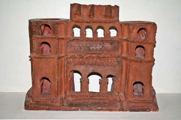
Clay model of a town or fort gate
| Clay model of the city or fort gate |
|---|
| Intercisa Múzeum, Dunaújváros
Link to the picture |
An important find, which also attracted international attention, was the 31 centimeter high model of a gate made of fired clay, which shows some architectural details that have never been proven archaeologically. The piece, preserved in great detail, came to light in 1907 during excavations by József Hampel and was created in the 2nd or 3rd century. The gate building has a three-part passage, which is flanked by two gate towers, which are still two stories high. They are missing at least one floor with the roofs. The towers are angular towards the front and are semicircular on the back. They have arched windows. The walkway connecting the two towers via the driveways has also been preserved. It is also two-story. The floors of the entire gateway are divided by two longitudinal cornices . Above the semicircular arches on the ground floor there is a diamond frieze that covers the entire width between the towers . The inscription (h) ILARVS FEC (it) PORTA (m) FEL (iciter) is incised in italics on a tabula ansata above the first cornice on the first floor . The second floor above the second cornice is divided by four arched openings, the angular uprights of which have an implied capital-like closure. In contrast to the tower roofs, the gable roof astride the walkway has been preserved. It has three dormers on the front . The model was associated with a gate construction in Aquincum . However, it could also - partly very freely - be modeled after one of the Intercisa warehouse gates .
Milestones
Several milestones come from Intercisa . One of them has only survived in fragments and gives the distance to the provincial capital Aquincum as 45 Roman miles. A second, fully preserved, was set up at Intercisa during the reign of Emperor Macrinus (217-218) . It states 47 Roman miles from Aquincum and was discovered in secondary use in the village of Szalkszentmárton . The then governor of Lower Pannonia, Aelius Decius Triccianus, is also mentioned here. Another milestone of Macrinus was already badly damaged. For a stone of Maximinus Thrax (235–238) the mileage has not been preserved. Three more of this emperor name 50 miles. Even Philip the Arab (244-249) left a stone whose indication miles but already missing.
Inscription on the building of Burgi
For the history of the Pannonian Limes, a building inscription dating from 180 to 183 AD is important, which was found carried away in a local vineyard. An identical copy was also found in the Limes Fort Matrica (see also: Roman stone monuments from Százhalombatta-Dunafüred ) on the area of the garrison. It can therefore be assumed that the inscription from Intercisa was once in the fort. The two documents testify to a major building program under Emperor Commodus (180–192) to secure the borders after the Marcomann Wars. The opponents in this border area, in this case the Sarmatians , who are difficult to assess for Rome , are called robbers . It is not possible to determine the time of the inscription more precisely because the stonemason (s) repeated the same dating error on both known inscriptions. The indications tribunicia potestate VI / imperator IIII (180 AD) and consul IIII (183 AD) do not match. As already shown above, the tenure of Lucius Cornelius Felix Plotianus can be located between 183 and 185 AD.
Imp (erator) Caes (ar) M (arcus) Aur (elius) [[C [ommod] us]]
Antoninus Aug (ustus) Pius Sarm (aticus) Germ (anicus) Brit {t} (annicus)
pont (ifex) max (imus) trib (unicia) pot (estate) VI imp (erator) IIII co (n) s (ul) IIII p (ater) p (atriae)
ripam omnem burgis a solo ex-
tructis item praesidis per loca
opportuna ad clandestinos latrun-
culorum transitus oppositis mu-
nivit per L (ucium) [[Cornelium Felicem]]
[[Plotianum leg (atum) pr (o) pr (aetore)]]
Translation: The emperor Caesar Marcus Aurelius Commodus Antoninus Augustus Pius, Sarmatian winner, German winner, Britannian winner, high priest, holder of tribunician power for the sixth time, emperor for the fourth time, consul for the fourth time, father of the fatherland, has all Burgi of his own accord on the riverbank , then fortified the forts at the opposite locations in order to forestall the passage of roaming robbers, by Lucius Cornelius Felix Plotianus, governor .
Lost property
The finds, which were obtained in the 19th century through purchases and later through excavations, are now distributed among several museums in the country. A large part is in the Hungarian National Museum in Budapest and in the Intercisa Museum in Dunaújváros. Important finds can also be viewed in the István-Király-Museum in Stuhlweissenburg as well as in Vienna , Berlin and Mainz (see Late Roman doll glasses ), which also made purchases in the 19th century. A milestone can be found in the Lapidarium of the Balaton Museum in Keszthely . In addition, many other archaeological collections in Europe have owned individual pieces from Intercisa since this time and an unspecified amount will have disappeared in the private and art trade.
Limes course between Fort Intercisa to Fort Annamatia
| route | Name / place | Description / condition |
|---|---|---|
| 6th | Dunaújváros (Burgus Intercisa 1) | A watchtower may have stood near a gas station in Dunaújváros. The discovery of a Roman milestone, building remains and information in ancient sources support this consideration. |
| 6th | Dunaújváros (Burgus Intercisa 8) | To the north of Béke Square in Dunaújváros there was a watchtower with a diamond-shaped moat. A corresponding historical aerial photo was published by the archaeologists Lóránd Radnai (1940) and Zsolt Visy (1978, 1980). The tower overbuilt today stood in a V-shaped angle, which lies between today's (Szórád Márton út) and the no longer preserved ancient street. This system can probably be dated to the time of the Tetrarchy , as was the case with the similarly designed Burgus Intercisa 10. |
| 6th | Dunaújváros, Béke ter (Burgus Intercisa 2) | While checking an aerial photograph for possible archaeological findings, another, younger watchtower was discovered by Radnai just south of Burgus Intercisa 8. It turned out that it was one of the towers, the remains of which had already been published in drawings by Marsigli. In 1973 and 1974 the tower on Béke Square was partially examined during an emergency excavation of the Intercisa Museum. A comprehensive investigation was impossible because most of the tower was built over. From the few sections that covered the trench, no datable findings could be recovered. It should be noted that the system was built in stone and was secured by two rectangular trenches placed one behind the other. The outer trench was 51 × 51 meters and was between 1.80 and 1.90 meters wide. Its preserved depth varied between 1.50 and two meters. There was a break in the ditch on the west side. There was a transition to the center of the facility. The inner trench was 25 × 25 meters, was 1.20 to 2.90 meters wide and 1.40 to 1.83 meters deep. Based on the excavations at Burgus Intercisa 6, Zsolt Visy dated the tower to the reign of Valentinian I, other scientific opinions leave open a time allocation. |
| 6th | Dunaújváros, Danube Steel Works (Burgus Intercisa 3) | Marsigli has also mapped this tower, which is secured in the aerial photo. It is located in the area of the Danube steel works in Dunaújváros, which were built at the beginning of the 1950s, and probably also dates from the Valentine period. As an obstacle to the approach, it had two rectangular trenches, one behind the other. |
| 6th | Dunaújváros, Danube Steel Works (Burgus Intercisa 15) | Unlike many other watchtowers along this route, Burgus Intercisa 15 has only recently become known. Visy published a new map of the route in 1989 as well as a historical aerial photo from 1940 showing the location of the unexcavated tower. The road station was 1100 meters south of Burgus Intercisa 3 and 64 meters east of Limesstrasse. Until the 1950s, the course of Landstrasse 6 coincided with the ancient road route, then the steelworks north of the tower cut through the historic network of roads. The aerial photo shows that Intercisa 15 - probably a wooden tower - stood at the corner of a confluence of two streams. A slightly diamond-shaped double trench surrounded the station. The axis of the inner trench is around 28 meters long, that of the outer trench around 45 meters. The dark discoloration in the center of the system indicates the actual tower location. It has a diameter of around 10 meters. The design of this station suggests an emergence during the Valentine reign. Intercisa 15 can hardly be researched archaeologically. The area is in a sector that the steel mill has covered since it was expanded to the south in the 1980s. Although the tower was not built over at that time, coal heaps and a road have been above its structures ever since. Only the southwest section of the trenches is still in open terrain. |
| 6th | Dunaújváros, Farkastanya (Burgus Intercisa 9) | The aerial photo shows a diamond-shaped ditch west of the old highway 6, which covers an area of around 45 × 45 meters. The structure is on the road as it was in the time of the Tetrarchy. However, it does not belong to the relocated route of the 4th century. Therefore, it seems likely that this tower dates to the late 3rd and early 4th centuries. |
| 6th | Dunaújváros, junction Papírgyári út - Highway 6 (Burgus Intercisa 4) | At the intersection of Papírgyári út and the modern, relocated highway 6, was the Burgus Intercisa 4, which is only known from the aerial photo. It stood on the highest point of a hill south of Dunaújváros. The tower was built over when the new road 6, which today is a bypass road to the west of Dunaújváros, was built. Only the edges of the approximately 50 × 50 meter square double trench remained visible in the aerial photo. |
| 6th | Kisapostag , petrol station (Burgus Intercisa 5) | The tower is right next to a gas station built in 1993 west of Landstrasse 6 on an agricultural area. It is surrounded by a 50 × 50 meter double moat and can be attributed to either the middle of the 4th century or the Valentine period. Late Roman readings that the archaeologist Jenő Fitz (1921–2011) secured at this point support this dating. Between 2008 and 2010, stone was picked up in the area of the tower . In Kisapostag a milestone from the reign of Emperor Gordian III. (238–244) recovered. |
| 6th | Kisapostag (Burgus Intercisa 10) |
The tower point is on a hill on the ascent to the Kisapostag plateau. This hill is located to the west over the highway 6 and north to the entrance to Kisapostag (Petőfi Sándor utca). The ancient road, in use during the 3rd century, ran east of the tower at the foot of the hill. Burgus Intercisa 10 was excavated in 1979. Agriculture had already largely destroyed most of the traces. It could be ensured that Intercisa 10 was constructed as a wooden tower and was surrounded by a diamond-shaped trench around three meters deep. This trench enclosed an area of around 42 × 47.7 meters. Late antique glazed ceramics were found in the backfilling of the trench, which allowed it to be dated to the middle of the 4th century. The tower itself could be from the time of the Tetrarchy. The place Kisapostag has become known archaeologically for an early Bronze Age urn field.
|
| 6th | Kisapostag plateau (Burgus Intercisa 6) | The tower point is on a flat hill at the end of the climb to the Kisapostag plateau. From here, on the one hand, signals could be exchanged with the northern, downhill Burgus Intercisa 10, and on the other hand, it was possible to maintain a connection to the road towers Intercisa 7 and 18, which are located directly on the plateau. The excavation of Intercisa 6, which took place in 1979, did not bring any particular gains in knowledge, as the area had already been heavily sanded by the plow. Therefore, no building structures could be secured. The facility was located on the Kisapostag plateau south of the approach to Kisapostag and north of the sports airfield on the west side of Landstrasse 6. The route of this road runs here directly above the Roman road. The tower site was surrounded by an almost square double moat. The two trenches were closer together on the eastern flank than on the other three sides. The outer trench was 48.40 meters in diameter, the inner 24.76 meters. Very few scattered debris from the actual tower were found during the excavation. However, they prove that the station was most likely built of stone. Post holes that could indicate a wooden tower were not found. The tower was built in the 4th century. Either at the beginning of it, or - as Zsolt Visy assumed - during the Valentine period. |
| 6th | Kisapostag plateau (Burgus Intercisa 7) | The unexcavated part of the tower is located near the southern edge of the Kisapostag plateau on the west side of Highway 6. It is surrounded by a square double ditch around 50 × meters. According to Visy, the visual impression can be attributed to the Valentine's reign. Two north-south running Roman roads are archaeologically secured between Intercisa 10 and 7. One follows the dead straight course of the modern country road, the other is located a short distance to the west and is somewhat more restless in its course. The Intercisa 6 and 7 towers are located directly between these two lines. At Intercisa 7 the Limes road bends slightly to the southeast and heads towards the Annamatia fort. A silver-coated bronze ring fibula was published as a reading from this place, which dates to the decades from the end of the third to the beginning of the fourth century. |
| 6th | Baracs , Kisapostag Plateau (Burgus Intercisa 18) | Immediately on the southern edge of the Kisapostag plateau - not far from Burgus Intercisa 7 - is the next tower point. From here, Annamatia fort could be signaled to the southeast. This was down the slope directly on the Danube. In the aerial photo, Intercisa 18 is clearly visible on an agricultural area. A dark discoloration can be seen in its center, the location of the actual road tower. It is enclosed by a diamond-shaped moat. According to its outward appearance, this tower was made of wood and, by analogy with the well-researched street tower Intercisa 10, came from the time of the Tetrarchy. This tower may have been the forerunner of the Valentine tower Intercisa 7. Both towers may not have existed at the same time due to their proximity. |
| 7th | Baracs | Annamatia fort was south of the last castle . |


Traces of the watchtowers along the Danube between Dunaújváros and Baracs
In addition to the chain of watchtowers along the Limes Road between Intercisa and Annamatia, the Romans also built a dense network of guard stations directly on the eastern edge of the Öreghegy and the Kisapostag plateau above the Danube flowing past to the south. At least some locations of these towers could be more or less reliably detected. No archaeological research has yet been carried out. The hills and plateaus along the river consist of mighty loess deposits in this area . The Danube has demolished the loess formations towering up on its west side to form steep walls that can reach a height of 50 to 60 meters along the route discussed here. The Romans were able to monitor the river from these heights, but they could also look far into the Sarmatian Barbaricum east of the Danube. Visy believed that these towers were built during the reign of Emperor Commodus.
| route | Name / place | Description / condition |
|---|---|---|
| 6th | Dunaújváros-Barátság (Burgus Intercisa 11) | There is an oral tradition according to which a Roman building should have been in today's Barátság district. Unfortunately, the information was insufficient to locate the object. Since the area is now largely built over, the search was concentrated on an aerial photo from the war year 1942. There are at least two spots where the moats of watchtowers could show up due to anomalies. The area is also interesting because a road leads down to the river bank, which certainly existed in Roman times. In addition to the assumption of a watchtower, it can be assumed that there was a port or Danube crossing in the valley that could be controlled in this way. Numerous Roman coins found in the Danube and directly on the opposite bank in the Roman Barbaricum support this assumption. Parts of these finds are in the Hungarian National Museum in Budapest, some are in private hands. The coins that Visy and the archaeologist Eszter B. Vágó found in 1969 were brought to the Intercisa Museum in Dunaújváros. The evaluation of the coins showed that they mainly date from the 3rd and 4th centuries. With the exception of the coin finds, the investigations carried out in 1969 on the presumed ship landing remained negative. The Danube may have washed away all the evidence. |
| 6th | Dunaújváros (Burgus Intercisa 12) | This tower site is relatively well documented, but its location is controversial. The archeology pioneer Flóris Rómer (1815–1889) left a sketch showing an 8 × 8 fathom (around 15 × 15 meters) tower on today's Sport-Straße. In 1926 Paulovics recorded the partially preserved remains of a watchtower with a circumferential trench near the height control point 153. In his opinion, Rómer's sketch, the place of manufacture of which could not be precisely localized until then, showed the tower he was investigating. The archaeologist Jenő Fitz (1921–2011) agreed with this judgment . When a small stone watchtower was destroyed during the construction of the Dunaújváros steelworks north of Koszider-Padlás in the early 1950s, Fitz identified it with Paulovic's tower. Visy did not agree with this opinion, since Paulovics tower was about 750 meters away from the place where the place mentioned by Fitz was. The tower, established in 1926, is likely to have been built in the Commodian era. |
| 6th | Dunaújváros (Burgus Intercisa 17) | Another possible tower location can only be deduced from a historical aerial photo from 1951. At this point, the industrial plateau slopes gently into the small Kozidóra valley, which runs northwest and southeast into the Danube. The rectangular moat measures around 58 × 58 meters. The trench itself is around ten meters wide. It encloses an inner area of around 35 × 35 meters. A dark discoloration of around ten meters in diameter located in the middle of this area indicates the actual watchtower. Whether this was a stone tower or a wooden tower cannot be decided on the basis of the aerial photo. Since similar buildings, which can be dated by means of inscriptions, date from the Commodian period, this could also apply to Intercisa 17. Then, however, the tower should have been built in stone. |
| 6th | Dunaújváros (Burgus Intercisa 13) | Also located in the industrial area of Dunaújváros, this watchtower can be seen in several aerial photographs. Today there is a dump for cement clinker from the steel works here. The tower had a circumferential, around 48 × 48 meter wide rectangular trench, which was about ten meters wide. Without taking into account the wall behind the trench, which was thrown up with the trench excavation, the inner surface of the facility was around 35 × 35 meters. At its center was a darker area around ten meters in diameter. This shows that this tower had the same structures as Intercisa 17 and, accordingly, was built in a building campaign like this one in the Commodian era. |
| 6th | Baracs (Burgus Intercisa 14) | Between Intercisa 13 and 14 there is a large gap in the connection between the Limes watchtowers. It is possible that the systems suspected there have not yet been discovered or have already been irretrievably lost. Intercisa 14 - around 800 meters north of Annamatia Fort - was first known through a map published in 1775 by Michael Karpe, who also documented Annamatia. At that time, the tower was still visible. Fitz speculated that the tower was erected between 183 and 185 AD. Visy interpreted the drawing by Karpe as a rather diamond-shaped tower. The system can be determined more precisely with an aerial photograph. It is located in an agricultural area at the southern end of the Kisapostag plateau on a spur of the loess plateau. A small depression cuts into the sediment immediately south of the tower from northwest to southeast towards the Danube. The actual tower site was surrounded by a double moat, with the exterior measuring around 60 × 60 meters. Unfortunately, aerial photos do not allow a more detailed definition. Since the area to be investigated has been designated as a local recreation area, excavations are not possible. Readings have not yet been recovered. |
| 7th | Baracs | Annamatia fort was south of the last castle . |
Monument protection
The monuments of Hungary are protected under the Act No. LXIV of 2001 by being entered in the register of monuments. The Intercisa fort and especially the Vicus (file number: 600/0200/008/2009) as well as all other Limes facilities belong to the nationally valuable cultural property as archaeological sites according to § 3.1. According to § 2.1, all finds are state property, regardless of where they are found. Violations of the export regulations are considered a criminal offense or a crime and are punished with imprisonment for up to three years.
See also
literature
Overview
- Zsolt Visy : The Pannonian Limes in Hungary . Theiss, Stuttgart 1988, ISBN 3-8062-0488-8 , pp. 100-105.
- Zsolt Visy: Intercisa. Dunaújváros in Roman times. Corvina Verlag, Budapest 1977.
Monographs
- László Barkóczi , Ferenc Fülep , Maria Radnoti-Alföldi u. a .: Intercisa (Dunapentele-Sztálinváros). History of the city in Roman times. Volume 1. Akadémiai Kiadó, Budapest 1954
- Maria Radnoti-Alföldi , László Barkóczi, Jenő Fitz and others: Intercisa. (Dunapentele). History of the city in Roman times. Volume 2. Akadémiai Kiadó, Budapest 1957
- Eszter B. Vágó ; István Bóna: The burial grounds of Intercisa I. The late Roman southeast cemetery. Akadémiai Kiadó, Budapest 1976, ISBN 963-05-1139-8 .
- Felix Teichner : The grave fields of Intercisa II. The old finds of the museum collections in Berlin, Mainz and Vienna. Inventory catalog. Volume 11. Museum of Prehistory and Early History SMPK, Berlin 2011.
Essays
- László Barkóczi: Details of the stone carving of the Trajan period in Gorsium and Intercisa. In: Alba Regia. 20, 1983, pp. 57-66.
- László Barkóczi, Ágnes Salamon : Archaeological information on the late Roman history of the Pannonian Limes - burial grounds of Intercisa I. In: Communications of the Archaeological Institute of the Hungarian Academy of Sciences. 4, 1973, pp. 73-95.
- László Barkóczi: warehouse and housing estate . In: László Barkóczi, Ferenc Fülep , Maria Radnoti-Alföldi u. a .: Intercisa I. (Dunapentele-Sztálinváros). History of the city in Roman times. (= László Barkoczi (Ed.): Archaeologia Hungarica 33). Akadémiai Kiadó, Budapest 1954, pp. 11-60.
- Mária T. Bíró : Historical overview of the leg carving workshops in Intercisa. In: Archaeologiai Értesitö. 134, 2009, pp. 63-79.
- M. Lang: Model of a Roman round tower from Dunapentele (Intercisa). In: Archaeologiai Értesitö. 30, 1920, pp. 24-27.
- Géza Facsar, István Skoflek, Ágnes Salamon: A capsule fruit (Antirrhinum) from a Roman bulla and bulls from intercisa burials. In: Communications from the Archaeological Institute of the Hungarian Academy of Sciences. 7, 1977, pp. 93-108.
- Barnabás Lőrincz, Zsolt Visy: The building history of the auxiliary fort of Intercisa . In: William Hanson , Lawrence Keppie (Eds.): Roman Frontier Studies 1979. Papers presented to the 12th International Congress of Roman Frontier Studies . BAR-IS 71 (Oxford 1980), pp. 681-701.
- Barnabás Lőrincz, Klára Szabó: Research in the auxiliary fort of Intercisa (1983–1984). In: Acta Archaeologica Academiae Scientiarum Hungaricae 31, 3/4, 1979, pp. 739–744 (= Hermann Vetters, Manfred Kandler (Ed.): The Roman Limes in Austria, files of the 14th International Limes Congress 1986 in Carnuntum. Issue 36 / 2, publishing house of the Austrian Academy of Sciences, Vienna 1990).
- Barnabás Lőrincz: The brick temple of the late Roman southeast cemetery of Intercisa. In: Acta Archaeologica Academiae Scientiarum Hungaricae. 31, 3/4, 1979, pp. 293-312.
- Zsolt Mráv : L. Cornelius Felix Plotianus, governor of Commodus in Pannonia Inferior and the building history of the auxiliary fort Intercisa (Dunaújváros, Hungary) In: Szilvia Bíró (ed.): Studia officina ... Studia in honorem Dénes Gabler. Mursella, Győr 2009, pp. 357–387.
- Zsolt Mráv: A litterae aureae inscription from Intercisa. In: Folia Archaeologica. 49/50, 2001/02, pp. 207-233.
- Franz Oelmann : The clay porta of Illarus from Intercisa. In: Contributions to older European cultural history. Volume 1. Festschrift for Rudolf Egger . Verlag des Geschichtsverein für Kärnten, Klagenfurt 1952, pp. 114–125.
- István Paulovics: An inscription from the flag sanctuary of Dunapentele. In: Archaeologiai Értesítő. 78, 1951, pp. 21-23.
- Ágnes Salamon: Late Roman stamped vessels from Intercisa. In: Folia Archaeologica. 50, 1969, pp. 53-62.
- Ágnes Salamon: Archaeological information on the late Roman history of the Pannonian Limes - antler manufacture in Intercisa. In: Communications from the Archaeological Institute of the Hungarian Academy of Sciences. 6, 1976, pp. 47-54.
- Klára Szabó: Fourteen bronze vessels from the Intercisa warehouse workshop. In: Hermann Vetters, Manfred Kandler (ed.): Files of the 14th International Limes Congress 1986 in Carnuntum. Austrian Academy of Sciences, Vienna 1990, ISBN 3-7001-1695-0 , pp. 745–752.
- Lóránt Vass: bone carving in Intercisa. In: Archaeologiai Értesítő. 134, 2009, pp. 81-90.
- Zsolt Visy: “Beneficiarii” on inscriptions from Intercisa. The question of an Intercisa beneficiary station. In: Antiquitas , Series 1, Abhandlungen zur alten Geschichte 61, 2013, pp. 359–376.
- Zsolt Visy: The reconstruction of the Roman traveling carriage from Dunaújváros. In: Archaeologiai Értesítő. 112, 1985, pp. 169-179.
- Zsolt Visy: Bases and fragments of imperial statues in Intercisa. In: Acta Archaeologica Academiae Scientiarum Hungaricae. 35, 1/2, 1983, pp. 73-85.
- Zsolt Visy: The monuments of the imperial cult in Intercisa. In: Scientific journal of the Humboldt University of Berlin, social and linguistic series. 31, 1982, p. 303ff.
- Zsolt Visy: Preliminary report on the excavations at Intercisa in the years 1970–1972. In: Alba Regia. 13, 1972, p. 258 ff.
Web links
- Intercisa Museum website (in Hungarian only; accessed May 6, 2014)
- Photos of the fort and the semi-detached house in the vicus at www.civertan.hu (accessed on May 6, 2014)
Remarks
- ↑ a b c d e Zsolt Visy: The Pannonian Limes in Hungary . Theiss, Stuttgart 1988, ISBN 3-8062-0488-8 , p. 100.
- ↑ Frühchristliche Church at 46 ° 58 '31.37 " N , 18 ° 56' 3.55" O .
- ^ Paul Lambrechts et al. a. (Ed.): Outline of the history of ancient marginal cultures. Oldenbourg, Munich 1961, p. 141.
- ^ Jenő Fitz, András Mócsy, Sándor Soproni : The Roman inscriptions of Hungary. 1. Delivery: Savaria, Scarbantia and the Limes route Ad Flexum - Arrabona. Akadémiai Kiadó, Budapest 1972, p. 15.
- ↑ a b c d Mária T. Bíró: Historical overview of the leg carving workshops in Intercisa. In: Archaeologiai Értesitö. 134, Issue 1, 2009, pp. 63-79; here p. 63.
- ^ A b Franz Oelmann : The clay porta of Illarus from Intercisa. In: Contributions to older European cultural history. Volume 1. Festschrift for Rudolf Egger . Verlag des Geschichtsverein für Kärnten, Klagenfurt 1952, pp. 114–125; here: p. 114.
- ^ Éva B. Bónis: István Járdányi Paulovics and the exploration of Pannonian glazed ceramics. In: Acta classica universitatis scientiarum Debreceniensis. Vol. 30, 1994, Kossuth Lajos Tudományegyetem Kiadói Bizottsága, Debrecen 1995, pp. 107-110; here: p. 108.
- ↑ a b c d e f g h i j Zsolt Visy: The Pannonian Limes in Hungary . Theiss, Stuttgart 1988, ISBN 3-8062-0488-8 , p. 101.
- ^ László Vértes: László Barkóczi. In: Andrea H. Vaday (Ed.): Pannonia and beyond. Studies in honor of László Barkóczi. (= Antaeus 24, 1997, 98) Budapest 1999, p. 9.
- ↑ Dénes Gabler, Andrea H. Vaday: Terra sigillata in the Barbaricum between Pannonia and Dazien. Akadémiai Kiadó, Budapest 1986, ISBN 963-05-3879-2 , p. 74.
- ^ Barnabás Lőrincz, Klára Szabó: Research in the auxiliary fort of Intercisa (1983-1984). In: Hermann Vetters, Manfred, Kandler (eds.): Files of the 14th International Limes Congress 1986 in Carnuntum. Verlag der Österreichischen Akademie der Wissenschaften, Vienna 1990, ISBN 3-7001-1695-0 , pp. 739–744; here: p. 741; Range of coins: Nero - 1 piece, Titus - 1 piece, Domitian - 3 pieces, Nerva - 2 pieces, Traian - 4 pieces, Hadrian - 4 pieces, Antoninus Pius - 14 pieces, Marcus Aurelius - 7 or 8 pieces.
- ^ Zsolt Visy: The ripa Pannonica in Hungary. Akadémiai Kiadó, Budapest 2003, ISBN 963-05-7980-4 , p. 121.
- ↑ a b c Barnabás Lőrincz, Klára Szabó: Research in the auxiliary fort of Intercisa (1983-1984). In: Hermann Vetters, Manfred, Kandler (eds.): Files of the 14th International Limes Congress 1986 in Carnuntum. Verlag der Österreichischen Akademie der Wissenschaften, Vienna 1990, ISBN 3-7001-1695-0 , pp. 739–744; here: p. 739.
- ^ Barnabás Lőrincz, Klára Szabó: Research in the auxiliary fort of Intercisa (1983-1984). In: Hermann Vetters, Manfred, Kandler (eds.): Files of the 14th International Limes Congress 1986 in Carnuntum. Verlag der Österreichischen Akademie der Wissenschaften, Vienna 1990, ISBN 3-7001-1695-0 , pp. 739–744; here: p. 740.
- ^ Zsolt Visy: Intercisa Castellum. In: Zsolt Visy (ed.): The Roman army in Pannonia. Teleki Lázló Foundation 2003, ISBN 963-86388-2-6 , pp. 116-118; here: p. 116.
- ^ A b Manfred Kandler: The auxiliary fort Carnuntum. Austrian Archaeological Institute, Vienna 1997, p. 40 (Austrian Archaeological Institute, special publications, volume 29).
- ↑ a b c Zsolt Visy: Intercisa Castellum. In: Zsolt Visy (ed.): The Roman army in Pannonia. Teleki Lázló Foundation 2003, ISBN 963-86388-2-6 , pp. 116-118; here: p. 117.
- ↑ Zsolt Mráv : L. Cornelius Felix Plotianus, governor of Commodus in Pannonia Inferior and the building history of the auxiliary fort Intercisa (Dunaújváros, Hungary) In: Szilvia Bíró (ed.): Studia officina ... Studia in honorem Dénes Gabler. Mursella, Győr 2009, pp. 357-387; here: pp. 375–383.
- ↑ Ján Rajtár , Klára Kuzmová : Previous findings on the fortification of the Roman fort in Iža. In: Slovenská Archeológia. Vol. 34, 1986, pp. 185-222; here: p. 200.
- ↑ a b Zsolt Visy: The ripa Pannonica in Hungary. Akadémiai Kiadó, Budapest 2003, ISBN 963-05-7980-4 , p. 76.
- ^ Slavko Ciglenečki: Slovenia. In: Reallexikon der Germanischen Altertumskunde (RGA). 2nd Edition. Volume 29, Walter de Gruyter, Berlin / New York 2005, ISBN 3-11-018360-9 , p. 123.
- ↑ a b c d Zsolt Visy: The Pannonian Limes in Hungary . Theiss, Stuttgart 1988, ISBN 3-8062-0488-8 , p. 102.
- ^ A b Zsolt Visy: Intercisa Castellum. In: Zsolt Visy (ed.): The Roman army in Pannonia. Teleki Lázló Foundation 2003, ISBN 963-86388-2-6 , pp. 116-118; here: p. 118.
- ↑ Endre Tóth : Group C. Fortifications with fan-shaped corner and U-shaped intermediate towers. In: Endre Tóth: The late Roman military architecture in Transdanubia. Archaeologiai Értesitő 134. Budapest 2009, p. 44.
- ↑ Endre Tóth: The late Roman military architecture in Transdanubia. Archaeologiai Értesitő 134. Budapest 2009, p. 52.
- ^ Barnabás Lőrincz, Klára Szabó: Research in the auxiliary fort of Intercisa (1983-1984). In: Acta Archaeologica Academiae Scientiarum Hungaricae. 31, 3/4, 1979, pp. 739-744; here: p. 741.
- ^ Zsolt Visy: Bases and fragments of imperial statues in Intercisa. In: Acta Archaeologica Academiae Scientiarum Hungaricae. 35, 1/2, 1983, pp. 73-85; here p. 73.
- ↑ a b c Zsolt Visy: The Pannonian Limes in Hungary . Theiss, Stuttgart 1988, ISBN 3-8062-0488-8 , p. 105.
- ↑ Zsolt Visy: The monuments of the imperial cult in Intercisa. In: Scientific journal of the Humboldt University of Berlin, social and linguistic series. 31, Berlin 1982, p. 303ff .; here: p. 304.
- ^ Zsolt Mráv: A litterae aureae inscription from Intercisa. In: Folia archaeologica. 49/50, 2001/02, pp. 207-233; here: p. 221; Barbara Pferdehirt : The ceramics of the Holzhausen fort. (= Limes research. 16). Mann, Berlin 1976, ISBN 3-7861-1070-0 , p. 18; Günter Ulbert , Thomas Fischer : The Limes in Bavaria . Theiss, Stuttgart 1983, ISBN 3-8062-0351-2 .
- ↑ István Paulovics: An inscription from the flag sanctuary of Dunapentele. In: Archaeologiai Értesítő. 78, 1951, pp. 21-23; here: p. 23.
- ^ AE 1953, 10 .
- ↑ Harald von Petrikovits : Contributions to Roman history and archeology II. Rheinland-Verlag, Cologne 1991, ISBN 3-7927-1222-9 , p. 256.
- ↑ a b Zsolt Visy: Intercisa - a Roman border fort on the Pannonian Limes. In: The ancient world. 24/1, Berlin 1978, pp. 106-111; here p. 111.
- ↑ a b Zsolt Visy: The Pannonian Limes in Hungary. Theiss, Stuttgart 1988, ISBN 3-8062-0488-8 , p. 103.
- ^ Klára Szabó: Fourteen bronze vessels from the Intercisa warehouse workshop. In: Hermann Vetters, Manfred Kandler (ed.): Files of the 14th International Limes Congress 1986 in Carnuntum. Austrian Academy of Sciences, Vienna 1990, ISBN 3-7001-1695-0 , pp. 740–752; here: p. 740.
- ^ Barnabás Lőrincz, Klára Szabó: Research in the auxiliary fort of Intercisa (1983-1984). In: Acta Archaeologica Academiae Scientiarum Hungaricae. 31, 3-4, 1979, pp. 739-741.
- ^ Edit B. Thomas : Helmets, shields, daggers. Studies of Roman-Pannonian weapons finds. Adolf M. Hakkert, Amsterdam 1971, p. 14.
- ↑ a b Barnabás Lőrincz: The Roman auxiliary troops in Pannonia during the principle time. Part I: The Inscriptions. Forschungsgesellschaft Wiener Stadtarchäologie, Vienna 2001, ISBN 3-902086-02-5 , p. 15.
- ↑ AE 1992, 1458 .
- ↑ CIL 3, 10323 .
- ↑ Barnabás Lőrincz: The Roman auxiliaries in Pannonia during the Principate's time. Part I: The Inscriptions. Forschungsgesellschaft Wiener Stadtarchäologie, Vienna 2001, ISBN 3-902086-02-5 , p. 111.
- ^ Jenő Fitz, András Mócsy, Sándor Soproni: The Roman inscriptions of Hungary. 1. Delivery: Savaria, Scarbantia and the Limes route Ad Flexum - Arrabona. Akadémiai Kiadó, Budapest 1972, No. 01233.
- ↑ Barnabás Lőrincz: The Roman auxiliaries in Pannonia during the Principate's time. Part I: The Inscriptions. Forschungsgesellschaft Wiener Stadtarchäologie, Vienna 2001, ISBN 3-902086-02-5 , p. 17.
- ↑ AE 1977, 638 .
- ↑ Tilmann Bechert: The Romans in Asciburgium (= Duisburg research. Volume 36). Braun, Duisburg 1989, ISBN 3-87096-047-7 , p. 61f.
- ↑ CIL 3,9735 .
- ↑ AE 1993, +01307 .
- ^ A b Manfred Kandler: The auxiliary fort Carnuntum. Austrian Archaeological Institute, Vienna 1997, p. 73 (Austrian Archaeological Institute, special publications, volume 29).
- ↑ Barnabás Lőrincz: The Roman auxiliaries in Pannonia during the Principate's time. Part I: The Inscriptions. Forschungsgesellschaft Wiener Stadtarchäologie, Vienna 2001, ISBN 3-902086-02-5 , p. 86.
- ↑ Barnabás Lőrincz: The Roman auxiliaries in Pannonia during the Principate's time. Part I: The Inscriptions. Research Society of Vienna City Archeology. Vienna 2001, ISBN 3-902086-02-5 , p. 26.
- ^ Jenő Fitz, András Mócsy, Sándor Soproni: The Roman inscriptions of Hungary. 1. Delivery: Savaria, Scarbantia and the Limes route Ad Flexum - Arrabona. Akadémiai Kiadó, Budapest 1972, No. 01220.
- ^ AE 1986, 598 .
- ↑ Barnabás Lőrincz: The Roman auxiliaries in Pannonia during the Principate's time. Part I: The Inscriptions. Research Society of Vienna City Archeology. Vienna 2001, ISBN 3-902086-02-5 , p. 24.
- ^ Jenő Fitz, András Mócsy, Sándor Soproni: The Roman inscriptions of Hungary. 1. Delivery: Savaria, Scarbantia and the Limes route Ad Flexum - Arrabona. Akadémiai Kiadó, Budapest 1972, No. 01252.
- ↑ a b Barnabás Lőrincz: The Roman auxiliary troops in Pannonia during the principle time. Part I: The Inscriptions. Research Society of Vienna City Archeology. Vienna 2001, ISBN 3-902086-02-5 , p. 18.
- ↑ Barbara Pferdehirt: Roman military diplomas and dismissal certificates in the collection of the Römisch-Germanisches Zentralmuseum . Mainz 2004, ISBN 3-88467-086-7 , p. 108.
- ^ Jenő Fitz, András Mócsy, Sándor Soproni: The Roman inscriptions of Hungary. 1. Delivery: Savaria, Scarbantia and the Limes route Ad Flexum - Arrabona. 1. Delivery. Akadémiai Kiadó, Budapest 1972, No. 01284.
- ↑ With more complete and complete names: under Commodus (180–192): Cohors I Aurelia Antoniniana milliaria Hemesenorum ( AE 2008, 1118 , AE 2008, 1118 ), Cohors I milliaria Antoniniana Hemesenorum ( AE 1910, 147 , AE 1964, 104 ), Cohors I Aurelia Antoniniana Hemesenorum ( AE 2008, 1119 , AE 2008, 1119 ); under Septimius Severus (193-211): 199-202 AD - Cohors miliaria Antoniniana Hemesenorum civium Romanorum sagittariorum ( AE 1910, 141 ); under Caracalla (211–217): 209–213 AD - Cohors I miliaria Hemesenorum Aurelia Antoniniana sagittariorum equitata civium Romanorum ( AE 1971, 334 ), 214 AD - Cohors milliaria Hemesenorum Antoniniana ( AE 1910, 133 ), 213-217 AD - Cohors I milliaria Hemesenorum Aurelia Antoniniana sagittaria equitata civium Romanorum (AAntHung-2011-353), Cohors I milliaria Hemesenorum Aurelia Antoniniana sagittariorum equitata ( AE 2005, 1246 ); under Elagabal (218–222): Cohors I milliaria Hemesenorum Aurelia Antoniniana sagittaria equitata civium Romanorum ( Péter Kovács , Ádám Szabó : Studia Epigraphica Pannonica 2. Budapest 2009, p. 159); under Severus Alexander (222-235): Cohors I milliaria Hemesenorum civium Romanorum sagittariorum (RIU-05, 01142), Cohors I Antonina milliaria Hemesenorum (RIU-05, 01249); under Maximinus Thrax (235-238): Cohors milliaria Hemesenorum Maximiniana ( AE 1975, 701 ); under Gordian III. (238-244): AD 239-240 - Cohors I milliaria Hemesenorum Gordiana sagittaria equitata civium Romanorum ( CIL 3, 3331 ).
- ↑ Barnabás Lőrincz: The Roman auxiliaries in Pannonia during the Principate's time. Part I: The Inscriptions. Research Society of Vienna City Archeology. Vienna 2001, ISBN 3-902086-02-5 , p. 35.
- ↑ Barnabás Lőrincz: The Roman auxiliaries in Pannonia during the Principate's time. Part I: The Inscriptions. Research Society of Vienna City Archeology. Vienna 2001, ISBN 3-902086-02-5 , p. 42.
- ^ Jenő Fitz, András Mócsy, Sándor Soproni: The Roman inscriptions of Hungary. 1. Delivery: Savaria, Scarbantia and the Limes route Ad Flexum - Arrabona. 1. Delivery. Akadémiai Kiadó, Budapest 1972, No. 01249.
- ↑ distress. dign. occ. XXXIII, 38
- ↑ distress. dign. occ. XXXIII, 25
- ↑ distress. dign. occ. XXXIII, 26
- ↑ Zsolt Visy: Intercisa - a Roman border fort on the Pannonian Limes. In: The ancient world. 24/1, Berlin 1978, pp. 106-111; here p. 110.
- ↑ military bath at 46 ° 58 '39.77 " N , 18 ° 56' 11.31" O .
- ↑ Zsolt Mráv : L. Cornelius Felix Plotianus, governor of Commodus in Pannonia Inferior and the building history of the auxiliary fort Intercisa (Dunaújváros, Hungary) In: Szilvia Bíró (ed.): Studia officina ... Studia in honorem Dénes Gabler. Mursella, Győr 2009, pp. 357-387; here: p. 365.
- ↑ AE 2008, 01118 .
- ↑ Zsolt Mráv : L. Cornelius Felix Plotianus, governor of Commodus in Pannonia Inferior and the building history of the auxiliary fort Intercisa (Dunaújváros, Hungary) In: Szilvia Bíró (ed.): Studia officina ... Studia in honorem Dénes Gabler. Mursella, Győr 2009, pp. 357-387; here: p. 365.
- ↑ AE 2010, 01274 .
- ↑ Zsolt Mráv : L. Cornelius Felix Plotianus, governor of Commodus in Pannonia Inferior and the building history of the auxiliary fort Intercisa (Dunaújváros, Hungary) In: Szilvia Bíró (ed.): Studia officina ... Studia in honorem Dénes Gabler. Mursella, Győr 2009, pp. 357-387; here: pp. 370–371.
- ↑ Zsolt Mráv : L. Cornelius Felix Plotianus, governor of Commodus in Pannonia Inferior and the building history of the auxiliary fort Intercisa (Dunaújváros, Hungary) In: Szilvia Bíró (ed.): Studia officina ... Studia in honorem Dénes Gabler. Mursella, Győr 2009, pp. 357-387; here: p. 373.
- ↑ Zsolt Mráv : L. Cornelius Felix Plotianus, governor of Commodus in Pannonia Inferior and the building history of the auxiliary fort Intercisa (Dunaújváros, Hungary) In: Szilvia Bíró (ed.): Studia officina ... Studia in honorem Dénes Gabler. Mursella, Győr 2009, pp. 357-387; here: pp. 362–365.
- ↑ a b Zsolt Mráv : L. Cornelius Felix Plotianus, governor of Commodus in Pannonia Inferior and the building history of the auxiliary fort Intercisa (Dunaújváros, Hungary) In: Szilvia Bíró (ed.): Studia officina ... Studia in honorem Dénes Gabler. Mursella, Győr 2009, pp. 357-387; here: p. 373.
- ↑ Zsolt Mráv : L. Cornelius Felix Plotianus, governor of Commodus in Pannonia Inferior and the building history of the auxiliary fort Intercisa (Dunaújváros, Hungary) In: Szilvia Bíró (ed.): Studia officina ... Studia in honorem Dénes Gabler. Mursella, Győr 2009, pp. 357-387; here: p. 375.
- ^ Péter Kovács , Barnabás Lőrincz : A new building inscription from Intercisa. In: Acta Archaeologica Academiae Scientiarum Hungaricae. 62, 2011/12, pp. 353-362, p. 353.
- ↑ AE 2010, 01273 .
- ↑ http://lupa.at/20155 Fragment of a building inscription , Ubi erat lupa
- ↑ Zsolt Mráv: Az intercisai auxiliáris castellum Commodus-kori monumentális építési feliratainak egy újabb töredéke - A new fragment to the Commodian building inscriptions of the auxiliary fort at Intercisa (Dunaújváros, County Fejér, Hungary) . In: Folia Archaeologica 54 (2008-2010), pp. 165-184; here: pp. 168–170.
- ↑ Zsolt Mráv: Az intercisai auxiliáris castellum Commodus-kori monumentális építési feliratainak egy újabb töredéke - A new fragment to the Commodian building inscriptions of the auxiliary fort at Intercisa (Dunaújváros, County Fejér, Hungary) . In: Folia Archaeologica 54 (2008-2010), pp. 165-184; here: p. 168.
- ↑ a b c Zsolt Visy: The Pannonian Limes in Hungary . Theiss, Stuttgart 1988, ISBN 3-8062-0488-8 , p. 104.
- ↑ Zsolt Visy: The reconstruction of the Roman traveling carriage of Dunaújváros. In: Archaeologiai értesítő. 112, 1985, pp. 169-179; here: pp. 178–179.
- ↑ detached house at 46 ° 58 '24.51 " N , 18 ° 56' 4.19" O .
- ↑ Heinz Heinen , Hans H. Anton, Winfried Weber : In the upheaval of cultures - late antiquity and early Middle Ages. Publications of the diocese archive Trier, ISBN 3-7902-0271-1 , p. 516.
- ^ Gösta Ditmar-Trauth: The Gallo-Roman house. Volume 1: On the nature and distribution of the house of the Gallo-Roman population in the Imperium Romanum. Publishing house Dr. Kovač, Hamburg 1995, ISBN 3-86064-349-5 , p. 34.
- ↑ CIL 3, 3327 .
- ↑ With explanation of the locality problem: Eszter B. Vágó ; István Bóna: The burial grounds of Intercisa I. The late Roman southeast cemetery. Akadémiai Kiadó, Budapest 1976, ISBN 963-05-1139-8 , p. 128.
- ^ Edit B. Thomas: Roman villas in Pannonia. Contributions to the Pannonian settlement history. Publishing house of the Hungarian Academy of Sciences, Budapest 1964, p. 239.
- ^ Edit B. Thomas: Roman villas in Pannonia. Contributions to the Pannonian settlement history. Publishing House of the Hungarian Academy of Sciences, Budapest 1964, p. 240.
- ↑ a b László Barkóczi: Pannonian glass finds in Hungary. Akadémiai Kiadó, Budapest 1988, ISBN 963-05-4286-2 , p. 34.
- ^ Katalin Ottományi : The late Latène-Roman settlement of Budaörs. In: Acta archaeologica Academiae Scientiarum Hungaricae. 56, 1-3, 2005, pp. 67-132; here: p. 69.
- ^ Joachim Ott: Considerations on the position of the beneficiarier in the hierarchy of the Roman army. In: Egon Schallmayer , Cordula Eibl, Joachim Ott: The Roman consecration district of Osterburken II. Colloquium 1990 and palaeobotanical-osteological studies. Theiss, Stuttgart 1994, ISBN 3-8062-1140-X , pp. 233-250; here: p. 248.
- ^ Eszter B. Vágó; István Bóna: The burial grounds of Intercisa I. The late Roman southeast cemetery. Akadémiai Kiadó, Budapest 1976, ISBN 963-05-1139-8 , p. 183.
- ↑ Zoltán Kádár : The Asia Minor-Syrian Cults in Roman Times in Hungary. EJ Brill, Leiden 1962, p. 19.
- ↑ Raktárak, Virtuális látványtár: Római mécsesek ( page no longer available , search in web archives ) Info: The link was automatically marked as defective. Please check the link according to the instructions and then remove this notice.
- ↑ Ferenc Fülep : 20th goal model. In: Ferenc Fülep: The Hungarian National Museum. Corvina Verlag, Budapest 1978, ISBN 963-13-0269-5 , p. 66.
- ↑ Photo of the model on the pages of www.arachne.uni-koeln.de .
- ↑ CIL 3, 3729 .
- ↑ CIL 3, 3726 .
- ↑ CIL 3, 10637 .
- ↑ AE 1975, 698 .
- ↑ AE 1975, 699 , AE 1975, 700 , AE 1975, 00701
- ↑ AE 1969/70, 512 .
- ↑ CIL 3, 3385 .
- ↑ AE 1910, 145 .
- ↑ a b route = numbering follows Zsolt Visy: The Pannonian Limes in Hungary (Theiss 1988) and Zsolt Visy: The ripa Pannonica in Hungary. (Akadémiai Kiadó 2003)
- ↑ Burgus Intercisa 1 at about 46 ° 58 '0.94 " N , 18 ° 56' 10.81" O .
- ↑ Burgus Intercisa 8 at about 46 ° 57 '36.29 " N , 18 ° 56' 7.22" O .
- ↑ a b c d e Zsolt Visy: The ripa Pannonica in Hungary. Akadémiai Kiadó, Budapest 2003, ISBN 963-05-7980-4 , p. 77.
- ↑ Burgus Intercisa 2 at 46 ° 57 '28.91 " N , 18 ° 56' 7.51" E ; Source: Frontiers of the Roman Empire - Ripa Pannonica in Hungary (RPH), Nomination Statement, Vol. 2 , National Office of Cultural Heritage, Budapest 2011, p. 107.
- ↑ a b Jenő Fitz: The Roman Limes in Hungary . (= Volume 22 of the István Király Múzeum) István Király Múzeum, Székesfehérvár 1976, p. 105.
- ↑ a b c Zsolt Visy: Pannonian Limes stretches on aerial photographs . In: Ancient World. 12, 4, 1981, pp. 39-52; here: p. 51.
- ^ A b Frontiers of the Roman Empire - Ripa Pannonica in Hungary (RPH), Nomination Statement, Vol. 2. National Office of Cultural Heritage, Budapest 2011, p. 107.
- ↑ Burgus Intercisa 3 approximately at 46 ° 56 '54.2 " N , 18 ° 55' 57.42" O .
- ↑ Burgus Intercisa 15 at approximately 46 ° 56 '15.91 " N , 18 ° 55' 59.73" O .
- ↑ Burgus Intercisa 9 at about 46 ° 55 '51.45 " N , 18 ° 55' 54.08" O .
- ↑ a b c d e f g h Zsolt Visy: The ripa Pannonica in Hungary. Akadémiai Kiadó, Budapest 2003, ISBN 963-05-7980-4 , p. 78.
- ↑ Burgus Intercisa 4 at approximately 46 ° 55 '29.06 " N , 18 ° 55' 50.22" O .
- ↑ Burgus Intercisa 5 at 46 ° 54 '56.27 " N , 18 ° 55' 38.46" O ; Source: Frontiers of the Roman Empire - Ripa Pannonica in Hungary (RPH), Nomination Statement, Vol. 2 , National Office of Cultural Heritage, Budapest 2011, p. 100.
- ^ A b Frontiers of the Roman Empire - Ripa Pannonica in Hungary (RPH), Nomination Statement, Vol. 2 , National Office of Cultural Heritage, Budapest 2011, p. 100.
- ↑ Zsolt Visy, Máté Szabó, Róbert Lóki, Annamária Priskin: Scientific Report of the University of Pécs (PP6) for the period between October 1, 2008 and March 31, 2010. Published research report by the University of Pécs
- ↑ AE 1969/70, 00522 .
- ↑ Burgus Intercisa 10 at 46 ° 54 '9.4 " N , 18 ° 55' 20.75" E ; Source: Frontiers of the Roman Empire - Ripa Pannonica in Hungary (RPH), Nomination Statement, Vol. 2 , National Office of Cultural Heritage, Budapest 2011, p. 100.
- ↑ Amália Mozsolics: The Early Bronze Age Urn Cemetery of Kisapostag . (= Archaeologia Hungarica 26), Budapest 1942.
- ↑ Burgus Intercisa 6 at 46 ° 53 '55.32 " N , 18 ° 55' 19.96" O ; Source: Frontiers of the Roman Empire - Ripa Pannonica in Hungary (RPH), Nomination Statement, Vol. 2 , National Office of Cultural Heritage, Budapest 2011, p. 100.
- ↑ Burgus Intercisa 7 at 46 ° 52 '53.95 " N , 18 ° 55' 4.25" O .
- ↑ a b c d Zsolt Visy: The ripa Pannonica in Hungary. Akadémiai Kiadó, Budapest 2003, ISBN 963-05-7980-4 , p. 79.
- ^ Zsolt Visy: The ripa Pannonica in Hungary. Akadémiai Kiadó, Budapest 2003, ISBN 963-05-7980-4 , plate 20.
- ↑ Zsolt Visy: A Danube Limes program régészeti kutatásai 2008–2011 között. PTE BTK Régészet Tanszékének, Pécs 2011, p. 164.
- ↑ Burgus Intercisa 18 at 46 ° 52 '44.27 " N , 18 ° 55' 2.56" O .
- ↑ a b Kastell Annamatia at 46 ° 52 '5.8 " N , 18 ° 55' 17.35" O .
- ↑ Burgus Intercisa 11 at approximately 46 ° 57 '35.43 " N , 18 ° 56' 51.8" O .
- ↑ Burgus Intercisa 12 at approximately 46 ° 56 '55.41 " N , 18 ° 57' 11.81" O .
- ↑ a b Zsolt Visy: The ripa Pannonica in Hungary. Akadémiai Kiadó, Budapest 2003, ISBN 963-05-7980-4 , p. 80.
- ↑ Burgus Intercisa 17 at approximately 46 ° 56 '28.81 " N , 18 ° 57' 17.72" O .
- ↑ Burgus Intercisa 13 at approximately 46 ° 55 '55.91 " N , 18 ° 57' 5.06" O .
- ↑ a b Zsolt Visy: The ripa Pannonica in Hungary. Akadémiai Kiadó, Budapest 2003, ISBN 963-05-7980-4 , p. 81.
- ↑ Burgus Intercisa 14 at approximately 46 ° 52 '45.95 " N , 18 ° 55' 33.27" O .