Žiar (Liptovský Mikuláš)
| Žiar | ||
|---|---|---|
| coat of arms | map | |

|
|
|
| Basic data | ||
| State : | Slovakia | |
| Kraj : | Žilinský kraj | |
| Okres : | Liptovský Mikuláš | |
| Region : | Liptov | |
| Area : | 21.894 km² | |
| Residents : | 468 (Dec. 31, 2019) | |
| Population density : | 21 inhabitants per km² | |
| Height : | 760 m nm | |
| Postal code : | 032 05 (Post Office Smrečany ) | |
| Telephone code : | 0 44 | |
| Geographic location : | 49 ° 8 ′ N , 19 ° 40 ′ E | |
| License plate : | LM | |
| Kód obce : | 511200 | |
| structure | ||
| Community type : | local community | |
| Administration (as of November 2018) | ||
| Mayor : | Ján Zvara | |
| Address: | Obecný úrad Žiar č. 102 032 05 Smrečany |
|
| Website: | www.obecziar.sk | |
| Statistics information on statistics.sk | ||
Žiar (until 1927 Slovak "Ziar", Hungarian Zsár ) is a municipality in the north of Slovakia with a population of 468 (December 31, 2019) that the Liptovský Mikuláš District of, part kraj Žilinský heard and the traditional landscape Liptov is counted .
geography
The community is located in the central part of the basin Liptovská kotlina (part of the larger Podtatranská kotlina ) below the West Tatra at the Smrečianka . The municipality includes the valley Žiarska dolina to the main ridge of the Western Tatras. The center of the village is at an altitude of 760 m nm and is 10 kilometers from Liptovský Mikuláš .
Neighboring municipalities are Zuberec in the north, Jamník in the northeast, Liptovský Mikuláš (district Svätý Štefan) in the east, Veterná Poruba in the south, Smrečany in the southwest and Jalovec in the west.
history
Žiar was founded in a forest clearing around 1300 and was first mentioned in writing in 1349 as a tsar , as a property of the Smrečiansky-Szentiványi family from the lower nobility. Until the second half of the 18th century, the place administratively belonged to the neighboring village of Smrečany. In 1715 11 taxpayers lived here, in 1784 the village had 24 houses and 251 inhabitants. In 1828 there were 42 houses and 400 residents who were employed as shepherds and charcoal burners.
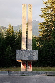
The place in Liptov County belonged to the Kingdom of Hungary until 1918 and then came to Czechoslovakia and finally to Slovakia. In the first Czechoslovak Republic, forestry and agriculture were the main sources of income for the population. On October 28, 1944, Žiar was set on fire by the Wehrmacht troops after fighting between partisans and Nazi German units.
population
According to the 2011 census, Žiar had 436 inhabitants, including 422 Slovaks , two Czechs and one Magyar . 11 residents did not provide any information on ethnicity .
245 residents supported the Evangelical Church AB, 102 residents the Roman Catholic Church, three residents the Evangelical Methodist Church, two residents the Greek Catholic Church and one resident of the Jehovah's Witnesses; one resident professed a different denomination. 56 inhabitants were without a denomination and the denomination of 26 inhabitants was not determined.
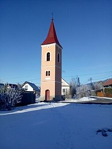
Buildings and monuments
Individual evidence
- ↑ Slovenské slovníky: názvy obcí Slovenskej republiky (Majtán 1998)
- ↑ Results of the 2011 census (Slovak)
Web links
- Entry on e-obce.sk (Slovak)


