
Hybe
| Hybe | |||
|---|---|---|---|
| coat of arms | map | ||

|
|
||
| Basic data | |||
| State : | Slovakia | ||
| Kraj : | Žilinský kraj | ||
| Okres : | Liptovský Mikuláš | ||
| Region : | Liptov | ||
| Area : | 52.822 km² | ||
| Residents : | 1,454 (Dec 31, 2019) | ||
| Population density : | 28 inhabitants per km² | ||
| Height : | 690 m nm | ||
| Postal code : | 032 31 | ||
| Telephone code : | 044 | ||
| Geographic location : | 49 ° 3 ' N , 19 ° 51' E | ||
| License plate : | LM | ||
| Kód obce : | 510467 | ||
| structure | |||
| Community type : | local community | ||
| Administration (as of November 2018) | |||
| Mayor : | Karol Pavlíček | ||
| Address: | Obecný úrad Hybe Hybe č. 2 03231 Hybe |
||
| Website: | www.hybe.sk | ||
| Statistics information on statistics.sk | |||

Hybe (Slovak from 1946 to 1954 "Hyby"; German Geib , Hungarian Hibbe ) is a municipality in Žilinský kraj in Slovakia .
geography

The place is located in the Podtatranská kotlina (Lower Tatras Basin) on the Hybica brook, 18 km east of Liptovský Mikuláš and 37 km west of Poprad . Its cadastral area is almost 53 km². Hybe can be reached via State Road 18 or the Hybe motorway exit ( D1 motorway ); there is a rail connection in the neighboring communities of Kráľova Lehota and Východná .
history
Hybe is mentioned for the first time in a document from 1239. In 1265 the place received city rights (Karpfener Recht) and became a market town at the end of the 13th century. There have also been attempts to promote mining, but they have not been very successful. The place belonged to the Liptovský Hrádok estate from the end of the 14th century .
Until 1918 the place in Liptov County belonged to the Kingdom of Hungary and then came to the newly formed Czechoslovakia or today Slovakia.
The tomb of the Hungarian poet Bálint Balassa and his family is located in the local Roman Catholic Church .
Personalities
- Dobroslav Chrobák (1907–1951), Slovak writer
- Albert Škarvan , Slovak Esperantist
gallery

Center Quo Vadis
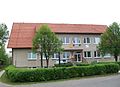
General office

D. Chrobák Memorial House

House of Albert SkARVAn
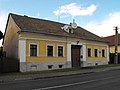
Albert Škarvan's house
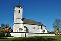
Protestant church
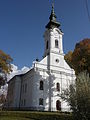
Rome Catholic Church of All Saints


.JPG)

Memorial plaques

Albert Škarvan
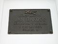
Ján Bakoss

Ján Šimkovic

Ľudevít Orphanides


