Prosiek
| Prosiek | ||
|---|---|---|
| coat of arms | map | |

|
|
|
| Basic data | ||
| State : | Slovakia | |
| Kraj : | Žilinský kraj | |
| Okres : | Liptovský Mikuláš | |
| Region : | Liptov | |
| Area : | 12.653 km² | |
| Residents : | 216 (Dec. 31, 2019) | |
| Population density : | 17 inhabitants per km² | |
| Height : | 608 m nm | |
| Postal code : | 032 23 ( Liptovská Sielnica post office ) | |
| Telephone code : | 0 44 | |
| Geographic location : | 49 ° 9 ′ N , 19 ° 30 ′ E | |
| License plate : | LM | |
| Kód obce : | 510971 | |
| structure | ||
| Community type : | local community | |
| Administration (as of November 2018) | ||
| Mayor : | Peter Hamráček | |
| Address: | Obecný úrad Prosiek č. 57 032 23 Liptovská Sielnica |
|
| Website: | www.prosiek.ocu.sk | |
| Statistics information on statistics.sk | ||
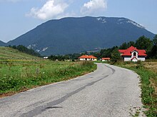
Prosiek (Hungarian Prószék - until 1888 Proszék ) is a municipality in northern Slovakia with 216 inhabitants (as of December 31, 2019), which belongs to the Okres Liptovský Mikuláš , part of the Žilinský kraj , and is part of the traditional Liptov region .
geography
The village is located in the central part of the Liptovská kotlina basin (part of the larger Podtatranská kotlina ) at the transition to the northern Choč Mountains in the Prosiečanka Valley , which flows from the Prosiecka dolina in the Choč Mountains. The northern part of the municipality is located in the Lower Tatras furrow (in Slovak Podtatranská brázda ) between the Choč Mountains and the Skorušinské vrchy . The center of the village lies at an altitude of 608 m nm and is 14 kilometers away from Liptovský Mikuláš .
Zádiel (first mentioned in 1735 as Zadiel ), which was incorporated in the middle of the 19th century , also belongs to the municipality .
Neighboring municipalities are Chlebnice and Veľké Borové in the north, Kvačany in the northeast, Liptovská Sielnica in the east and south, Ižipovce in the west and Liptovská Anna and Malatiná in the northwest.
history
To the north of the village, at the foot of the Hrádok mountain in the Choč Mountains, there was a settlement from the Hallstatt and Latène times.
Prosiek was mentioned in writing indirectly as Prezeky in 1287, directly in 1352 . In 1391 the village was owned by the Jób and Kubínyi families . In 1784 the Jób family had 20 houses and 171 inhabitants and the Kubínyi family 23 houses and 194 inhabitants, in 1828 there were 58 houses and 536 inhabitants who were employed as farmers.
The place in Liptov County belonged to the Kingdom of Hungary until 1918 and then came to Czechoslovakia and finally to Slovakia. In the first Czechoslovak Republic, too, agriculture remained the main source of income for the population.
population
According to the 2011 census, Prosiek had 197 inhabitants, 189 of them Slovaks and one Czech . Seven residents did not provide any information about their ethnicity.
105 residents committed themselves to the Roman Catholic Church, 61 residents to the Evangelical Church AB, seven residents to the Greek Catholic Church and one resident to the Czechoslovak Hussite Church. 14 residents were without a denomination and the denomination was not determined for nine residents.
Buildings and monuments
- Roman Catholic Elisabeth Church, originally a Gothic chapel from the 14th century, redesigned in the Renaissance style and expanded into a church in 1827
Individual evidence
- ↑ Slovenské slovníky: názvy obcí Slovenskej republiky (Majtán 1998)
- ↑ Results of the 2011 census (Slovak)
Web links
- Entry on e-obce.sk (Slovak)


