Clastres
| Clastres | ||
|---|---|---|

|
|
|
| region | Hauts-de-France | |
| Department | Aisne | |
| Arrondissement | Saint-Quentin | |
| Canton | Ribemont | |
| Community association | Saint-Quentinois | |
| Coordinates | 49 ° 45 ' N , 3 ° 14' E | |
| height | 63-95 m | |
| surface | 8.24 km 2 | |
| Residents | 635 (January 1, 2017) | |
| Population density | 77 inhabitants / km 2 | |
| Post Code | 02440 | |
| INSEE code | 02199 | |
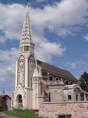
 Saint-Sulpice church |
||
Clastres is a French commune of 635 inhabitants (at January 1, 2017) in the Aisne department in the region of Hauts-de-France ; it belongs to the arrondissement of Saint-Quentin and the canton of Ribemont .
geography
The municipality of Clastres is about twelve kilometers southwest of Saint-Quentin . In the south-west, the municipality extends to the Canal de Saint-Quentin , in the north-west there used to be a military airfield .
Population development
| year | 1962 | 1968 | 1975 | 1982 | 1990 | 1999 | 2009 | 2016 |
| Residents | 482 | 529 | 447 | 534 | 559 | 509 | 607 | 652 |
Attractions
- Saint-Sulpice church
Web links
Commons : Clastres - collection of images, videos and audio files
