Fluquières
| Fluquières | ||
|---|---|---|
|
|
||
| region | Hauts-de-France | |
| Department | Aisne | |
| Arrondissement | Saint-Quentin | |
| Canton | Saint-Quentin-1 | |
| Community association | Pays du Vermandois | |
| Coordinates | 49 ° 48 ' N , 3 ° 9' E | |
| height | 82-101 m | |
| surface | 5.24 km 2 | |
| Residents | 220 (January 1, 2017) | |
| Population density | 42 inhabitants / km 2 | |
| Post Code | 02590 | |
| INSEE code | 02317 | |
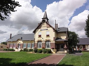
 City Hall (Mairie) and School of Fluquières |
||
Fluquières is a French commune of 220 inhabitants (at January 1, 2017) in the Aisne department in the region of Hauts-de-France (before 2016 Picardy ). It belongs to the Arrondissement Saint-Quentin , the canton Saint-Quentin-1 (until 2015 Vermand ) and the municipality association Pays du Vermandois .
geography
Fluquières is surrounded by the neighboring municipalities of Douchy in the west, Germaine and Vaux-en-Vermandois in the northwest, Étreillers in the northeast, Roupy in the east and the municipalities of Happencourt in the canton of Ribemont in the southeast and Tugny-et-Pont in the southwest.
history
At the beginning of the First World War , Fluquières was occupied by German troops in late August 1914. In February 1917 the population was evacuated. Of the 626 residents in 1911, only 198 returned to their home village after the war by 1921.
Population development
| year | 1962 | 1968 | 1975 | 1982 | 1990 | 1999 | 2006 | 2015 |
| Residents | 162 | 200 | 181 | 189 | 184 | 197 | 197 | 220 |
| Source: Cassini and INSEE | ||||||||
Attractions
- Saint-Médard church


