Berthenicourt
| Berthenicourt | ||
|---|---|---|
|
|
||
| region | Hauts-de-France | |
| Department | Aisne | |
| Arrondissement | Saint-Quentin | |
| Canton | Ribemont | |
| Community association | Val de l'Oise | |
| Coordinates | 49 ° 46 ' N , 3 ° 23' E | |
| height | 58-108 m | |
| surface | 3.07 km 2 | |
| Residents | 199 (January 1, 2017) | |
| Population density | 65 inhabitants / km 2 | |
| Post Code | 02240 | |
| INSEE code | 02075 | |
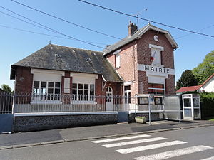
 Town Hall (Mairie) of Berthenicourt |
||
Berthenicourt one is French municipality with 199 inhabitants (at January 1, 2017) in the Aisne department in the region of Hauts-de-France (before 2016 Picardy ). It belongs to the Arrondissement of Saint-Quentin , to the canton of Ribemont (until 2015 Moÿ-de-l'Aisne ) and to the municipal association Val de l'Oise .
geography
The municipality is located in the valley of the Oise . The Sambre-Oise Canal runs in the immediate vicinity . Berthenicourt is surrounded by the neighboring communities of Urvillers in the north-west, Itancourt in the north, Mézières-sur-Oise in the east, Séry-lès-Mézières in the south-east and Alaincourt in the south-west and west.
Population development
| year | 1962 | 1968 | 1975 | 1982 | 1990 | 1999 | 2007 | 2015 |
| Residents | 181 | 176 | 187 | 177 | 200 | 200 | 207 | 202 |
| Source: Cassini and INSEE | ||||||||
Attractions
- The Saint-Basle church, originally built in the twelfth century, was destroyed during the First World War and rebuilt in the same place in 1925 in neo-Romanesque style.
Web links
Commons : Berthenicourt - collection of images, videos and audio files

