
Serain
| Serain | ||
|---|---|---|
.svg)
|
|
|
| region | Hauts-de-France | |
| Department | Aisne | |
| Arrondissement | Saint-Quentin | |
| Canton | Bohain-en-Vermandois | |
| Community association | Pays du Vermandois | |
| Coordinates | 50 ° 2 ′ N , 3 ° 22 ′ E | |
| height | 114-152 m | |
| surface | 6.65 km 2 | |
| Residents | 405 (January 1, 2017) | |
| Population density | 61 inhabitants / km 2 | |
| Post Code | 02110 | |
| INSEE code | 02709 | |
_mairie_et_%C3%A9cole.JPG) City Hall (Mairie) and School of Serain |
||

Serain is a French municipality with 405 inhabitants (at January 1, 2017) in the department of Aisne in the region of Hauts-de-France . It belongs to the Arrondissement Saint-Quentin , the canton Bohain-en-Vermandois and the municipality association Pays du Vermandois .
geography
Serain is surrounded by the neighboring communities Prémont in the east and southeast, Beaurevoir in the south and from the Nord located communities Malincourt the west and Élincourt in the north.
history
During the First World War , the village was occupied by German troops from August 28, 1914 to October 1918. Initially, Serain was removed from the immediate front line and served as a base for the German army. The place was liberated on October 8, 1918 after hard fighting by the 66th British Division . In view of the suffering of the population during the four years of occupation and the severe damage to the buildings, Serain was awarded the Croix de Guerre 1914–1918 on April 19, 1921 .
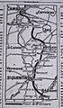
Map of the course of the front on October 8, 1918

The village destroyed in the war in 1919


Population development
| year | 1962 | 1968 | 1975 | 1982 | 1990 | 1999 | 2007 | 2015 |
| Residents | 612 | 534 | 501 | 459 | 404 | 420 | 390 | 411 |
| Source: Cassini and INSEE | ||||||||
Attractions
- Saint-Sauveur church, historic monument since 1914
- Serain Communal Cemetery Extension, CWGC military cemetery with 110 war graves.

Saint-Sauveur church

Serain Communal Cemetery Extension
_%C3%A9glise.JPG)

Web links
Individual evidence
- ^ Entry in the Base Mérimée of the Ministry of Culture. Retrieved December 15, 2018 (French).