
Nauroy
| Nauroy | ||
|---|---|---|
|
||
| region | Hauts-de-France | |
| Department | Aisne | |
| Arrondissement | Saint-Quentin | |
| Canton | Bohain-en-Vermandois | |
| Community association | Pays du Vermandois | |
| Coordinates | 49 ° 57 ′ N , 3 ° 15 ′ E | |
| height | 93-152 m | |
| surface | 6.27 km 2 | |
| Residents | 703 (January 1, 2017) | |
| Population density | 112 inhabitants / km 2 | |
| Post Code | 02420 | |
| INSEE code | 02539 | |
_mairie.JPG) Town Hall (Mairie) of Nauroy |
||

Nauroy is a French municipality with 703 inhabitants (as of January 1 2017) in the Aisne department in the region of Hauts-de-France (before 2016 Picardy ). The municipality belongs to the arrondissement of Saint-Quentin and the canton of Bohain-en-Vermandois (until 2015 Le Catelet ).
geography
Nauroy is about 17 kilometers north of Saint-Quentin . Nauroy is surrounded by the neighboring communities of Gouy in the north, Estrées in the northeast, Joncourt in the east, Magny-la-Fosse in the south and southeast, Bellenglise in the south and southwest and Bellicourt in the west and northwest.
Population development
| year | 1962 | 1968 | 1975 | 1982 | 1990 | 1999 | 2006 | 2013 |
| Residents | 663 | 666 | 683 | 685 | 728 | 681 | 683 | 725 |
| Source: Cassini and INSEE | ||||||||
Attractions
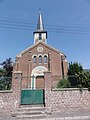
- Saint-Léger church from the 15th century, rebuilt in 1926
- Protestant church from 1867, today a gallery
- British war cemetery

Saint-Léger church
protestant church
_%C3%A9glise.JPG)
_ancienne_chapelle.JPG)
Personalities
- Désiré François Laugée (1823–1896), painter, Mayor of Nauroy in the 1880s
- Georges Laugée (1853–1937), painter, son of Désiré Laugée
Web links
Commons : Nauroy - collection of images, videos and audio files