Vendhuile
| Vendhuile | ||
|---|---|---|
|
|
||
| region | Hauts-de-France | |
| Department | Aisne | |
| Arrondissement | Saint-Quentin | |
| Canton | Bohain-en-Vermandois | |
| Community association | Pays du Vermandois | |
| Coordinates | 50 ° 1 ' N , 3 ° 13' E | |
| height | 83-143 m | |
| surface | 10.96 km 2 | |
| Residents | 556 (January 1, 2017) | |
| Population density | 51 inhabitants / km 2 | |
| Post Code | 02420 | |
| INSEE code | 02776 | |
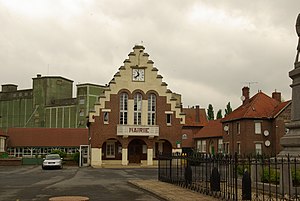
 Vendhuile Town Hall (Mairie) |
||
Vendhuile is a French municipality with 556 inhabitants (as of January 1 2017) in the Aisne department in the region of Hauts-de-France (2015 Picardy ). It belongs to the Arrondissement Saint-Quentin , the canton Bohain-en-Vermandois (until 2015 Le Catelet ) and the municipality association Pays du Vermandois .
geography
The hamlet of La Terrière , around 5 kilometers northeast of Vendhuile, consists of forty houses and a church. A quarter of its territory belongs to the municipality of Vendhuile, the remaining three quarters are in the area of Honnecourt-sur-Escaut . Vendhuile is surrounded by the neighboring communities of Aubencheul-aux-Bois and Gouy in the northeast, Bony in the southeast, Lempire in the south and southwest as well as by the municipality of Épehy in the Somme department in the west and the municipality of Honnecourt-sur-Escaut in the northwest, which is part of the northern department .
Population development
| year | 1962 | 1968 | 1975 | 1982 | 1990 | 1999 | 2007 | 2015 |
| Residents | 695 | 604 | 537 | 480 | 450 | 476 | 508 | 565 |
| Source: Cassini and INSEE | ||||||||
Attractions
- Saint-Martin church, built in 1927, monument historique since 1994
Web links
Individual evidence
- ^ Entry in the Base Mérimée of the Ministry of Culture. Retrieved December 16, 2018 (French).

