
Ramicourt
| Ramicourt | ||
|---|---|---|
|
||
| region | Hauts-de-France | |
| Department | Aisne | |
| Arrondissement | Saint-Quentin | |
| Canton | Bohain-en-Vermandois | |
| Community association | Pays du Vermandois | |
| Coordinates | 49 ° 58 ′ N , 3 ° 20 ′ E | |
| height | 116-155 m | |
| surface | 3.82 km 2 | |
| Residents | 150 (January 1, 2017) | |
| Population density | 39 inhabitants / km 2 | |
| Post Code | 02110 | |
| INSEE code | 02635 | |
_mairie.JPG) Ramicourt Town Hall (Mairie) |
||

Ramicourt is a French commune of 150 inhabitants (as of January 1, 2017) in the Aisne department in the region of Hauts-de-France (before 2016 Picardy ). It belongs to the Arrondissement Saint-Quentin , the canton Bohain-en-Vermandois and the municipality association Pays du Vermandois .
geography
Ramicourt is surrounded by the neighboring communities of Beaurevoir in the north, Montbrehain in the east, Sequehart in the southeast, Levergies in the southwest and Joncourt in the west.
history
From 1900 to 1950 Ramicourt was on the 1951 disused railway line from Le Catelet to Guise . The station building was demolished in the 1970s. Today there is a grain silo at its location.

Railway station around 1910
(postcard)
Grain silo on the site of the former station


First World War
During the First World War , Ramicourt was occupied by German troops on August 28, 1914. On October 2, 1918, the place was liberated by British and Australian troops.

Town hall square around 1920 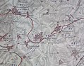
Map showing the destruction caused by the fighting in Ramicourt and the surrounding area in 1918


Population development
| year | 1962 | 1968 | 1975 | 1982 | 1990 | 1999 | 2006 | 2015 |
| Residents | 227 | 205 | 176 | 184 | 169 | 178 | 175 | 157 |
| Source: Cassini and INSEE | ||||||||
Attractions
- Sainte-Bernadette Church
_%C3%A9glise_Sainte-Bernadette.JPG)