
Brissy-Hamégicourt
| Brissy-Hamégicourt | ||
|---|---|---|
|
||
| region | Hauts-de-France | |
| Department | Aisne | |
| Arrondissement | Saint-Quentin | |
| Canton | Ribemont | |
| Community association | Val de l'Oise | |
| Coordinates | 49 ° 45 ' N , 3 ° 23' E | |
| height | 54-112 m | |
| surface | 12.38 km 2 | |
| Residents | 653 (January 1, 2017) | |
| Population density | 53 inhabitants / km 2 | |
| Post Code | 02240 | |
| INSEE code | 02124 | |
_mairie_%C3%A0_Brissy.JPG) Town hall ( Mairie ) of Brissy-Hamégicourt |
||

Brissy-Hamégicourt is a French municipality with 653 inhabitants (as of January 1 2017) in the Aisne department in the region of Hauts-de-France (before 2016: Picardy ); it belongs to the arrondissement of Saint-Quentin and the canton of Ribemont (until 2015: canton of Moÿ-de-l'Aisne ).
geography
Brissy-Hamégicourt is located about 13 kilometers south-southeast of Saint-Quentin on the Oise and on the Canal de la Sambre à l'Oise . Brissy-Hamégicourt is surrounded by the neighboring communities of Alaincourt in the north and north-west, Séry-lès-Mézières in the north and north-east, Renansart in the east and south-east, Brissay-Choigny in the south and Moÿ-de-l'Aisne in the west.
The A26 autoroute runs through the municipality .
history
In 1965 the parishes of Brissy and Hamégicourt were united.
Population development
| year | 1962 | 1968 | 1975 | 1982 | 1990 | 1999 | 2006 | 2013 |
| Residents | 413 | 814 | 741 | 726 | 715 | 626 | 637 | 640 |
| Source: Cassini and INSEE | ||||||||
Attractions
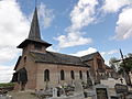
- Saint-Maixent church in Brissy from the 15th century
- Sainte-Benoite Church in Hamégicourt from the 15th century
- old town hall of Hamégicourt

Saint-Maixent church
Sainte-Benoite Church
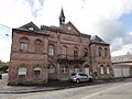
old town hall of Hamégicourt
_%C3%A9glise_de_Brissy_(02).JPG)
_%C3%A9glise_d%27Ham%C3%A9gicourt.JPG)
_ancienne_mairie_d%27Ham%C3%A9gicourt.JPG)