
Homblières
| Homblières | ||
|---|---|---|
.svg)
|
|
|
| region | Hauts-de-France | |
| Department | Aisne | |
| Arrondissement | Saint-Quentin | |
| Canton | Saint-Quentin-3 | |
| Community association | Saint-Quentinois | |
| Coordinates | 49 ° 51 ′ N , 3 ° 22 ′ E | |
| height | 72-135 m | |
| surface | 14.29 km 2 | |
| Residents | 1,464 (January 1, 2017) | |
| Population density | 102 inhabitants / km 2 | |
| Post Code | 02720 | |
| INSEE code | 02383 | |
| Website | http://www.homblieres.fr/ | |
_mairie.JPG) Town hall (Mairie) of Homblières |
||

Homblières is a commune with 1,464 inhabitants (as of January 1 2017) in the Aisne department in the region of Hauts-de-France . It belongs to the arrondissement of Saint-Quentin and the canton of Saint-Quentin-3 (until 2015: canton of Saint-Quentin-Sud ).
geography
Homblières is located about five kilometers east of the city center of Saint-Quentin on the small river Muid Proyard . Homblières is surrounded by the neighboring communities of Remaucourt , Essigny-le-Petit and Fonsomme in the north, Fontaine-Notre-Dame in the northeast, Marcy in the east, Regny in the southeast, Mesnil-Saint-Laurent in the south, Harly in the southwest, and Rouvroy in the west as well Morcourt in the northwest.
Population development
| 1962 | 1968 | 1975 | 1982 | 1990 | 1999 | 2006 | 2013 |
|---|---|---|---|---|---|---|---|
| 820 | 891 | 915 | 1,223 | 1,495 | 1,462 | 1,439 | 1,499 |
| Source: Cassini and INSEE | |||||||
Attractions
- Saint-Etienne church
- Rectory
- Park and gate to the former monastery of Sainte-Hunegonde
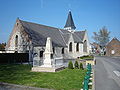
Saint-Etienne church

Gate to the park of the Sainte-Hunegonde monastery

_porche_du_parc_de_l%27Abbaye_Sainte_Hunegonde.JPG)
Personalities
- Pia Colombo (1934–1986), Italian-French singer