
Levergies
| Levergies | ||
|---|---|---|
|
||
| region | Hauts-de-France | |
| Department | Aisne | |
| Arrondissement | Saint-Quentin | |
| Canton | Bohain-en-Vermandois | |
| Community association | Pays du Vermandois | |
| Coordinates | 49 ° 56 ' N , 3 ° 19' E | |
| height | 94-155 m | |
| surface | 7.67 km 2 | |
| Residents | 545 (January 1, 2017) | |
| Population density | 71 inhabitants / km 2 | |
| Post Code | 02420 | |
| INSEE code | 02426 | |
_mairie.JPG) City Hall (Mairie) of Levergies |
||

Levergies is a French municipality with 545 inhabitants (as of January 1 2017) in the Aisne department in the region of Hauts-de-France (before 2016 Picardy ). It belongs to the Arrondissement Saint-Quentin , the canton Bohain-en-Vermandois (until 2015 Le Catelet ) and the municipality association Pays du Vermandois .
geography
Levergies is surrounded by the neighboring municipalities of Lehaucourt in the west, Magny-la-Fosse and Joncourt in the northwest, Ramicourt in the northeast, Sequehart in the east and the municipality of Lesdins in the canton of Saint-Quentin-2 in the south.
history
From 1892 to 1954 Levergies was on the now disused railway line from Le Catelet to Saint-Quentin .
During the First World War , Levergies was occupied by German troops on August 28, 1914. After heavy fighting, the 32nd British Division recaptured the village on September 30, 1918.
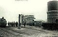
Station and water tower around 1908 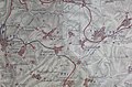
Map showing the destruction caused by the 1918 fighting in Levergies and the surrounding area


Population development
| year | 1962 | 1968 | 1975 | 1982 | 1990 | 1999 | 2006 | 2015 |
| Residents | 534 | 512 | 536 | 566 | 601 | 577 | 601 | 555 |
| Source: Cassini and INSEE | ||||||||
Attractions
- Saint-Médard church
_%C3%A9glise.JPG)