
Magny-la-Fosse
| Magny-la-Fosse | ||
|---|---|---|
|
||
| region | Hauts-de-France | |
| Department | Aisne | |
| Arrondissement | Saint-Quentin | |
| Canton | Bohain-en-Vermandois | |
| Community association | Pays du Vermandois | |
| Coordinates | 49 ° 56 ' N , 3 ° 17' E | |
| height | 92-144 m | |
| surface | 3.63 km 2 | |
| Residents | 125 (January 1, 2017) | |
| Population density | 34 inhabitants / km 2 | |
| Post Code | 02420 | |
| INSEE code | 02451 | |
_mairie.JPG) Town hall (Mairie) of Magny-la-Fosse |
||

Magny-la-Fosse is a French municipality with 125 inhabitants (as of January 1 2017) in the Aisne department in the region of Hauts-de-France (before 2016 Picardy ). It belongs to the Arrondissement Saint-Quentin , the canton Bohain-en-Vermandois (until 2015 Le Catelet ) and the municipality association Pays du Vermandois .
geography
Magny-la-Fosse is surrounded by the neighboring communities of Nauroy in the north-west and north, Joncourt in the north-east, Levergies in the east, Lehaucourt in the south and Bellenglise in the west.
history
During the First World War , Magny-la-Fosse was captured by German troops on August 28, 1914. The occupation lasted until the liberation by British and Australian associations in October 1918.
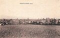
Magny-la-Fosse before the First World War 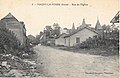
Magny-la-Fosse around 1920. 
Ruins of the place around 1920.


Population development
| year | 1962 | 1968 | 1975 | 1982 | 1990 | 1999 | 2007 | 2015 |
| Residents | 128 | 139 | 131 | 145 | 160 | 141 | 131 | 124 |
| Source: Cassini and INSEE | ||||||||
Attractions
- Saint-Léger church from the 16th century
_%C3%A9glise_(01).JPG)
Web links
Commons : Magny-la-Fosse - Collection of images, videos and audio files