
Sissy (aisne)
| Sissy | ||
|---|---|---|

|
|
|
| region | Hauts-de-France | |
| Department | Aisne | |
| Arrondissement | Saint-Quentin | |
| Canton | Ribemont | |
| Community association | Val de l'Oise | |
| Coordinates | 49 ° 48 ' N , 3 ° 26' E | |
| height | 62–127 m | |
| surface | 10.76 km 2 | |
| Residents | 476 (January 1, 2017) | |
| Population density | 44 inhabitants / km 2 | |
| Post Code | 02240 | |
| INSEE code | 02721 | |
_mairie.JPG) Town Hall (Mairie) of Sissy |
||

Sissy is a French municipality with 476 inhabitants (as of January 1 2017) in the Aisne department in the region of Hauts-de-France . It belongs to the arrondissement of Saint-Quentin , the canton of Ribemont and the Val de l'Oise municipal association .
geography
_Canal_de_la_Sambre_%C3%A0_l%27Oise,_%C3%A9cluse_28.JPG)
The community is located on Departementsstrasse 12, around twelve kilometers south-east of Saint-Quentin. Several arms of the Oise as well as the Sambre-Oise Canal cross the village. Surrounded Sissy from neighboring communities Regny in the northwest, Thenelles in the northeast, the canton capital Ribemont in the east and southeast, Châtillon-sur-Oise and Mezieres-sur-Oise in the southwest, as well as in the District of Saint-Quentin-3 located communities Neuville-Saint- Amand to the west and Mesnil-Saint-Laurent to the northwest.
Population development
| year | 1962 | 1968 | 1975 | 1982 | 1990 | 1999 | 2007 | 2015 |
| Residents | 607 | 591 | 513 | 510 | 483 | 502 | 494 | 474 |
| Source: Cassini and INSEE | ||||||||
Attractions
- Notre-Dame church
- Ruins of the Chapelle des Dormants , Monument historique since 1920
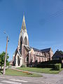
Notre-Dame church

Chapelle des Dormants
_%C3%A9glise.JPG)
_Chapelle_des_Endormis_MH_(03).JPG)
Web links
Individual evidence
- ^ Entry in the Base Mérimée of the Ministry of Culture. Retrieved November 24, 2018 (French).