La Ferté-Chevresis
| La Ferté-Chevresis | ||
|---|---|---|
|
|
||
| region | Hauts-de-France | |
| Department | Aisne | |
| Arrondissement | Saint-Quentin | |
| Canton | Ribemont | |
| Community association | Val de l'Oise | |
| Coordinates | 49 ° 44 ′ N , 3 ° 34 ′ E | |
| height | 56-131 m | |
| surface | 23.92 km 2 | |
| Residents | 542 (January 1, 2017) | |
| Population density | 23 inhabitants / km 2 | |
| Post Code | 02270 | |
| INSEE code | 02306 | |
| Website | www.ribemont.fr | |
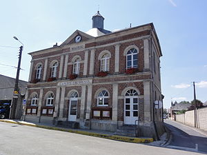
 Town hall (Mairie) of La Ferté-Chevresis |
||
La Ferte-Chevresis is a French municipality with 542 inhabitants (as of January 1 2017) in the department of Aisne in the region of Hauts-de-France ; it belongs to the arrondissement of Saint-Quentin and is part of the canton of Ribemont . The inhabitants are called Fertois .
geography
La Ferté-Chevresis is located about 22 kilometers southeast of Saint-Quentin . La Ferté-Chevresis is surrounded by the neighboring communities of Pleine-Selve , Parpeville and Chevresis-Monceau in the north, Pargny-les-Bois in the east, Montigny-sur-Crécy in the south and south-east, Mesbrecourt-Richecourt in the south, Nouvion-et-Catillon in the south-west, Surfontaine in the west and Villers-le-Sec in the north-west.
history
In the first half of the 19th century, the community was formed by the previously independent communes of La Ferté-sur-Péron and Chevresis-lès-Dames .
Population development
| year | 1962 | 1968 | 1975 | 1982 | 1990 | 1999 | 2006 | 2012 |
| Residents | 847 | 830 | 714 | 665 | 626 | 567 | 589 | 582 |
Attractions
- Saint-Brice church
- Wayside shrine La Vierge Marie
- Calvaire
- Old casino
- old trainstation


