
Idro
| Idro | ||
|---|---|---|

|
|
|
| Country | Italy | |
| region | Lombardy | |
| province | Brescia (BS) | |
| Local name | Ìder | |
| Coordinates | 45 ° 44 ′ N , 10 ° 29 ′ E | |
| height | 368 m slm | |
| surface | 22 km² | |
| Residents | 1,899 (Dec. 31, 2019) | |
| Population density | 86 inhabitants / km² | |
| Post Code | 25074 | |
| prefix | 0365 | |
| ISTAT number | 017082 | |


Idro ( German : Ider ) is a municipality in the Val Sabbia with 1899 inhabitants (as of December 31, 2019) in the northern Italian Alps , west of Lake Garda . It is located on Lake Idro .
Location and dates
The place consists of the districts Tre Capitelli, Pieve Vecchia, Lemprato, Crone, Vantone, Paröle and Vesta. There is no district of Idro. The neighboring municipalities are Anfo , Bagolino , Bondone (TN), Capovalle , Lavenone , Treviso Bresciano , Valvestino . The place is located on the narrow south side of Lake Idro and has about 1887 inhabitants (as of February 28, 2007) with an area of 22 km².
Settlements and memorial stones partly testify to the Rhaeto-Romanic times. Some castles, old town houses and many churches date from the Middle Ages . Fortifications like the Rocca d'Anfo (belongs to the municipality of Anfo) were built in Venetian times. There are not yet any large new building complexes, so that the typical Italian atmosphere has been preserved in the area and the villages, in the narrow streets, courtyards decorated with flowers and old courtyards.
Districts
Tre Capitelli
Tre Capitelli is the only district on the west bank of the lake.
Pieve Vecchia
Pieve Vecchia (old parish) is the "traffic junction" of the place: From the state road SS237 from Ponte Cáffaro to Brescia the provincial road SP58 branches off via Capovalle to Gargnano on Lake Garda .
Lemprato
Lemprato is the first district on the east bank. This is where the Ostuferstrasse begins and ends in Vesta. Lemprato houses the parish church, a school, a kindergarten and the town hall.
Crone
The largest district is Crone on the southeast bank. Around 1910, the overburden from nearby tunnels (see under Vesta) was removed from the lake, which now forms the market square and park. Crone is also considered the economic center of Idro. Most of the shops for daily needs are here, and there are several restaurants and bars. The municipality's town hall is also located on the outskirts of Crone. The district is the starting point for a via ferrata tour on the Cima Crench .
Vantone
Vantone is characterized by several, very nicely laid out and well-known campsites among campers. Here the mountain stream Rio Vantone plunges into the lake, on whose alluvial cone is Vantone.
Paroils
Paröle is a settlement that consists almost exclusively of weekend houses.
Vesta
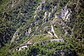
Vesta lies on the alluvial cone of the Rio Vesta. As in Paröle, there are only holiday homes here. Vesta is the last district on the east side of the lake that can be reached by car from the south. Paröle and Vesta could only be reached by land with vehicles after tunnels pierced the rocks, which protrude steeply into the lake, made it possible to drive through (around 1910).
photos
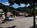
Crone Market Place

Shopping alley in Crone

Church in Crone
The Rocca d´Anfo fortress


Web links
Individual evidence
- ↑ Statistiche demografiche ISTAT. Monthly population statistics of the Istituto Nazionale di Statistica , as of December 31 of 2019.

Acquafredda | Adro | Agnosines | Alfianello | Anfo | Angolo Terme | Artogne | Azzano Mella | Bagnolo Mella | Bagolino | Barbariga | Barghe | Bassano Bresciano | Bedizzole | Berlingo | Berzo Demo | Berzo Inferiore | Bienno | Bione | Borgo San Giacomo | Borgosatollo | Borno | Botticino | Bovegno | Bovezzo | Brandico | Braone | Breno | Brescia | Brione | Caino | Calcinato | Calvagese della Riviera | Calvisano | Capo di Ponte | Capovalle | Capriano del Colle | Capriolo | Carpenedolo | Castegnato | Castel Mella | Castelcovati | Castenedolo | Casto | Castrezzato | Cazzago San Martino | Cedegolo | Cellatica | Cerveno | Ceto | Cevo | Chiari | Cigole | Cimbergo | Cividate Camuno | Coccaglio | Collebeato | Collio | Cologne | Comezzano-Cizzago | Concesio | Corte Franca | Corteno Golgi | Corzano | Darfo Boario Terme | Dello | Desenzano del Garda | Edolo | Erbusco | Esine | Fiesse | Flero | Gambara | Gardone Riviera | Gardone Val Trompia | Gargnano | Gavardo | Ghedi | Gianico | Gottolengo | Gussago | Idro | Incudine | Irma | Iseo | Isorella | Lavenone | Leno | Limone sul Garda | Lodrino | Lograto | Lonato del Garda | Longhena | Losine | Lozio | Lumezzane | Maclodio | Magasa | Mairano | Malegno | Malonno | Manerba del Garda | Manerbio | Marcheno | Marmentino | Chestnut | Mazzano | Milzano | Moniga del Garda | Monno | Monte Isola | Monticelli Brusati | Montichiari | Montirone | Mura | Muscoline
Nave | Niardo | Nuvolento | Nuvolera | Odolo | Offlaga | Ome | Ono San Pietro | Orzinuovi | Orzivecchi | Ospitaletto | Ossimo | Padenghe sul Garda | Paderno Franciacorta | Paisco Loveno | Paitone | Palazzolo sull'Oglio | Paratico | Paspardo | Passirano | Pavone del Mella | Pertica Alta | Pertica Bassa | Pezzaze | Pian Camuno | Piancogno | Pisogne | Polaveno | Polpenazze del Garda | Pompiano | Poncarale | Ponte di Legno | Pontevico | Pontoglio | Pozzolengo | Pralboino | Preseglie | Prestine | Prevalle | Provaglio Val Sabbia | Provaglio d'Iseo | Puegnago sul Garda | Quinzano d'Oglio | Remedello | Rezzato | Roccafranca | Rodengo-Saiano | Roncadelle | Rovato | Roè Volciano | Rudiano | Sabbio Chiese | Sale Marasino | Salò | San Felice del Benaco | San Gervasio Bresciano | San Paolo | San Zeno Naviglio | Sarezzo | Saviore dell'Adamello | Sellero | Seniga | Serle | Sirmione | Soiano del Lago | Sonico | Sulzano | Tavernole sul Mella | Temù | Tignale | Torbole Casaglia | Toscolano Maderno | Travagliato | Tremosine sul Garda | Trenzano | Treviso Bresciano | Urago d'Oglio | Vallio Terme | Valvestino | Verolanuova | Verolavecchia | Vestone | Vezza d'Oglio | Villa Carcina | Villachiara | Villanuova sul Clisi | Vione | Visano | Vobarno | Zone