Collebeato
| Collebeato | ||
|---|---|---|

|
|
|
| Country | Italy | |
| region | Lombardy | |
| province | Brescia (BS) | |
| Local name | Cobiàt | |
| Coordinates | 45 ° 34 ′ N , 10 ° 13 ′ E | |
| height | 200 m slm | |
| surface | 5 km² | |
| Residents | 4,598 (Dec 31, 2019) | |
| Population density | 920 inhabitants / km² | |
| Post Code | 25060 | |
| prefix | 030 | |
| ISTAT number | 017057 | |
| Popular name | Collebeatesi | |
| Patron saint | Paul | |
| Website | Collebeato | |
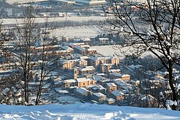
Collebeato is a northern Italian municipality ( comune ) with 4598 inhabitants (as of December 31, 2019) in the province of Brescia in Lombardy . The municipality is located about 5.5 kilometers north-northwest of Brescia in the Val Trompia on the Mella .
history
In 1014 the place Cubiadum is mentioned in a document.
In 2012 a stumbling block was laid in the community , see list of stumbling blocks in Collebeato .
Economy and Transport
Cellatica and peaches are grown in the municipality . The municipality is connected to the Brescia public transport network.
Parish partnership
Collebeato has maintained an intra-Italian partnership with the municipality of Bivona in the Free Municipal Consortium of Agrigento ( Sicily ) since 2004 .
Individual evidence
- ↑ Statistiche demografiche ISTAT. Monthly population statistics of the Istituto Nazionale di Statistica , as of December 31 of 2019.
- ^ Posa di 1 Pietra d'inciampo a Collebeato. (No longer available online.) In: CCDC: Cooperativa Cattolico-democratica di Cultura. Archived from the original on December 29, 2017 ; Retrieved December 28, 2017 (Italian). Info: The archive link was inserted automatically and has not yet been checked. Please check the original and archive link according to the instructions and then remove this notice.
Web links
Commons : Collebeato - collection of pictures, videos and audio files


