
Laignes (Cote-d'Or)
| Laignes | ||
|---|---|---|
.svg)
|
|
|
| region | Bourgogne-Franche-Comté | |
| Department | Côte-d'Or | |
| Arrondissement | Montbard | |
| Canton | Châtillon-sur-Seine | |
| Community association | Pays Châtillonnais | |
| Coordinates | 47 ° 51 ' N , 4 ° 22' E | |
| height | 202-288 m | |
| surface | 40.02 km 2 | |
| Residents | 692 (January 1, 2017) | |
| Population density | 17 inhabitants / km 2 | |
| Post Code | 21330 | |
| INSEE code | 21336 | |
 Town hall (Mairie) of Laignes |
||

Laignes is a French municipality with 692 inhabitants (as of January 1 2017) in the Côte-d'Or department in the region of Bourgogne Franche-Comté . The municipality belongs to the arrondissement of Montbard and the canton of Châtillon-sur-Seine (until 2015: canton of Laignes ).
geography
Laignes is about 76 kilometers northwest of Dijon and about 60 kilometers east of Auxerre am Laignes . Laignes is surrounded by the neighboring communities Griselles in the north, Marcenay in the northeast, Bissey-la-Pierre in the east, Balot in the east and southeast, Nesle-et-Massoult in the south and southeast, Fontaines-les-Sèches in the south, Sennevoy-le- Bas in the southwest, Gigny in the west and Nicey in the northwest.
Population development
| year | 1962 | 1968 | 1975 | 1982 | 1990 | 1999 | 2006 | 2013 |
| Residents | 1,032 | 1,073 | 1.004 | 1.008 | 904 | 881 | 878 | 759 |
| Source: Cassini and INSEE | ||||||||
Attractions
- Saint-Didier church, historic monument since 1930
- Chapel of Sainte-Marguerite
- Café Les Chiens Blancs, Monument historique since 1995

View of the Saint Didier church
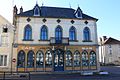
Café Les Chiens Blancs


Personalities
- Christine Petit (* 1948), geneticist