Le Passage (Lot-et-Garonne)
| Le passage | ||
|---|---|---|

|
|
|
| region | Nouvelle-Aquitaine | |
| Department | Lot-et-Garonne | |
| Arrondissement | Agen | |
| Canton | Agen-4 | |
| Community association | Agen | |
| Coordinates | 44 ° 12 ′ N , 0 ° 36 ′ E | |
| height | 36-110 m | |
| surface | 12.89 km 2 | |
| Residents | 9,561 (January 1, 2017) | |
| Population density | 742 inhabitants / km 2 | |
| Post Code | 47520 | |
| INSEE code | 47201 | |
| Website | http://www.ville-lepassage.fr/ | |
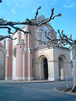
 Saint Joseph Church |
||
Le Passage is a commune with 9561 inhabitants (as of January 1 2017) in the department of Lot-et-Garonne in the region Nouvelle-Aquitaine . It is located in the Arrondissement of Agen and belongs to the canton of Agen-4 . The inhabitants are called Passageoises .
geography
Le Passage is located on the Garonne and Canal de Garonne . Le Passage is surrounded by the neighboring communities of Foulayronnes in the north, Agen in the east, Boé in the southeast, Moirax in the south, Brax , Roquefort and Estillac in the west and Colayrac-Saint-Cirq in the northwest.
Part of Agen Airport is in the municipal area.
Population development
| year | 1962 | 1968 | 1975 | 1982 | 1990 | 1999 | 2006 | 2011 |
|---|---|---|---|---|---|---|---|---|
| Residents | 5,669 | 6,746 | 7,862 | 8,553 | 8,875 | 8,827 | 9.097 | 9,389 |
history
With the French Revolution in 1789, Le Passage was created from two districts (Dolmayrac and Monbusq). Because of its proximity to Agen , the municipality was then called Le Passage d'Agen .
Town twinning
- Consuegra , Castile-La Mancha, Spain
- Włoszczowa , Świętokrzyskie Voivodeship, Poland
Attractions
- Saint-Joseph and Saint-Jehanne-de-France churches
- Notre-Dame de Beauregard Carmelite Convent
- Hippodrome
- Wash house
- Canal bridge
- Pierre Lapoujade Cultural Center
- Library
- town hall
A blues festival has been held in Le Passage since 2005.
Personalities
- Joachim-Jérôme Quiot du Passage (1775–1849), General
- Paul Dangla (1878–1906), racing cyclist, world record holder (fatally injured in Magdeburg, buried in Le Passage)
- Jean-Vital Jammes (1825-1893), opera singer (baritone)
