
Loei (province)
| Loei | |
|---|---|
| เลย | |

|
|
| statistics | |
| Capital: | Loei |
| Telephone code: | 042 |
| Surface: |
11,424.6 km² 14. |
| Residents: |
661,000 (2011) 40. |
| Population density : | 54 E / km² 70. |
| ISO 3166-2 : | |
| Governor : | |
| map | |
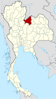  |
|
Loei ( Thai : เลย , [ lɤ̄ːj ]) is a province ( Changwat ) in the northeast region of Thailand , the so-called Isan . The capital of the province of Loei is also called Loei .
geography
The province lies on the northern border between Thailand and Laos , which is essentially formed by the Mekong . The distance to the capital Bangkok is just over 500 kilometers.
The topography is characterized by two bounding mountain ranges and a central lowland, in which the provincial capital is also located.
| Neighboring provinces and areas: | |
|---|---|
| north | Mekong , also the national border with Laos |
| east | Nong Khai , Udon Thani , Nong Bua Lam Phu and Khon Kaen |
| south | Phetchabun |
| west | Phitsanulok |
Important rivers
- Mekong
- Mae Nam Loei (Loei River)
climate
The climate is tropical - monsoonal . The highest temperature was 43.3 ° C, the lowest temperature ever recorded in Thailand was -1.3 ° C. The relatively low temperatures of the winter months are due to the north-south orientation of the valleys, which offer little protection from the cold mainland winds from China.
Data for 2009: The maximum temperature in 2009 was 39.4 ° C, the lowest temperature was measured at 7.0 ° C. On 125 rainy days fell in the same year 1347.8 mm of precipitation.
Economy and Importance
In 2011 (2010), the "Gross Provincial Product" (was GDP ) of the province 35,240 (30,067) million baht , the GPP per Capita in 2011 was 53,279 Baht.
Data
The table below shows the share of the economic sectors in the gross provincial product in percent.
| Industry | 2006 | 2007 | 2008 |
|---|---|---|---|
| Agriculture | 33.1 | 35.4 | 35.7 |
| Industry | 2.6 | 3.1 | 3.0 |
| Other | 64.3 | 61.5 | 61.3 |
All figures in%
Land use
The following land use is documented for the province:
- Forest area: 2,454,052 Rai (1,533.8 km²), 34.4% of the total area
- Agricultural area: 2,712,082 Rai (1,695.1 km²), 38.0% of the total area
- Unclassified area: 1,974,249 rai (1,233.9 km²), 27.7% of the total area
The province of Loei has a total of 325 wetlands with an area of 19.5 km², which are used more or less intensively for agriculture .
In addition to rice, important products are : corn , sugar beet , tapioca , cotton , soy , mung beans , tamarind , longan and lychee . There are also several large wine-growing areas. For some years now, the cultivation of rubber trees for harvesting raw rubber has been used as a lucrative branch of business.
traffic
Airport
Bus transport
Loei bus terminal
Trunk roads
- Highway 201
- Highway 203
- Highway 210
- Highway 211
Educational institutions
- Loei Rajabhat University
- Loei Technical College
- Loei Vocation College
Health facilities
- Chiang Khan Hospital in Chiang Khan
- Tha Li Hospital in Tha Li
- Loei Hospital in Loei
- Loei Ram Hospital in Loei
- Chittawet Loei Hospital in Loei
- Wang Saphung Hospital in Wang Saphung
- Pha Khao Hospital in Pha Khao
history
Historically, the area was part of the Lao Kingdom of Lan Xang .
The provincial capital was founded in 1853 by King Mongkut (Rama IV.) After careful planning in order to be able to adequately manage the growing population of the area. In the course of the great administrative reform of King Chulalongkorn (Rama V) , Loei was established as a province ( Changwat ) in 1907 .
Attractions


( See also the corresponding entry in Loei )
- The Wat Pa Huai Lat forest temple in Tambon San Tom, Amphoe Phu Ruea
- Phra That Si Song Rak - ( see seal ), ruin located on Mae Nam Man (Thai: แม่น้ำ หมัน - Man River ) in the Amphoe Dan Sai , with a chedi about 30 meters high
- Kaeng Khut Khu (Thai: แก่ง คุดคู้ - "winding rapids") - rapids in the Mekong ( Amphoe Chiang Khan ) with multicolored, smoothly ground rocks
- the city of Chiang Khan on the Mekong - very beautiful old wooden buildings
- Celebrations:
- Cotton bloom - in February, with a procession in picturesque cotton robes and costumes and a beauty contest
-
National parks and nature reserves:
- Phu Kradueng - high plateau, unusual in Thailand because of the moderate climate and the associated vegetation forms, about 70 kilometers from Loei in the Phu Kradueng district at an average altitude of 1325 meters
- Phu Luang Game Reserve (Phu Luang Wildlife Sanctuary) with numerous animal species, including elephants, tigers, bears, is about 1550 meters above sea level
Symbols

The seal of the province shows the Chedi Phra That Si Song Rak, which was built in 1560 by King Chakkraphat of Ayutthaya and King Sai Setthathirath I of Lan Xang to demonstrate their cooperation and also to mark the border between the two realms.
The local tree is the pine Pinus kesiya .
The motto of the province of Loei is:
- "Loei, the province in high mountain ranges,
- Beautiful flowers bloom in winter, summer and rainy season,
- The coolest city where temperatures always drop
- almost to freezing point, which cools us down. "
Administrative units
Provincial Administration
The province of Loei is divided into 14 Amphoe (“districts” or “counties”). These are further subdivided into 89 tambon ("subdistricts" or "communities") and 839 muban ("villages").
|

Local administration
A provincial administrative organization ( บริหาร ส่วน จังหวัด , อบ จ for short , Ongkan Borihan suan Changwat ; English Provincial Administrative Organization , PAO) exists for the entire area of the province .
There are two Thesaban Mueang ( เทศบาล เมือง - "cities") in the province : Loei ( เทศบาล เมือง เลย ) and Wang Saphung ( เทศบาล เมือง วังสะพุง ).
There are also 19 thesaban tambon ( เทศบาล ตำบล - "small towns").
Individual evidence
- ↑ Gross Regional and Provincial Product 1995-2011: Complete data as zip. ( Memento of the original from October 5, 2013 in the Internet Archive ) Info: The archive link was inserted automatically and has not yet been checked. Please check the original and archive link according to the instructions and then remove this notice.
- ↑ Thailand in Figures (2011)
- ↑ Thailand in Figures (2011)
- ↑ Edmund JV Oh, Blake D. Ratner, Simon Bush, Komathi Kolandai and Terence Y. Too (eds.): Wetlands Governance in the Mekong Region: country reports on the legal-institutional framework and economic valuation of aquatic resources . 2005.
- ↑ Department of Provincial Administration : As of 2012 (in Thai)
literature
- Thailand in Figures 2011 . Nonthaburi: Alpha Research 13 A. 2011. ISBN = 9786167526034.
Web links
- Province website (in Thai)
- Overview map of the province (names in English and Thai) [last accessed on November 13, 2013]
- Loei Province Tourist Information - Tourism Authority of Thailand TAT website
North : Chiang Mai | Chiang Rai | Kamphaeng Phet | Lampang | Lamphun | Mae Hong Son | Nakhon Sawan | Nan | Phayao | Phetchabun | Phichit | Phitsanulok | Phrae | Sukhothai | Tak | Uthai Thani | Uttaradit
Northeast : Amnat Charoen | Bueng Kan | Buri Ram | Chaiyaphum | Kalasin | Khon Kaen | Loei | Maha Sarakham | Mukdahan | Nakhon Phanom | Nakhon Ratchasima | Nong Bua Lam Phu | Nong Khai | Roi Et | Sakon Nakhon | Si Sa Ket | Surin | Ubon Ratchathani | Udon Thani | Yasothon
Central : Ang Thong | Ayutthaya | Bangkok | Chachoengsao | Chai Nat | Chanthaburi | Chon Buri | Kanchanaburi | Lop Buri | Nakhon Nayok | Nakhon Pathom | Nonthaburi | Pathum Thani | Phetchaburi | Prachin Buri | Prachuap Khiri Khan | Ratchaburi | Rayong | Sa Kaeo | Samut Prakan | Samut Sakhon | Samut Songkhram | Saraburi | Sing Buri | Suphan Buri | Stepped
South : Chumphon | Krabi | Nakhon Si Thammarat | Narathiwat | Pattani | Phang-nga | Phatthalung | Phuket | Ranong | Satun | Songkhla | Surat Thani | Trang | Yala
Coordinates: 17 ° 29 ' N , 101 ° 43' E