Hahnenkamm (Spessart)
| Cockscomb | ||
|---|---|---|
|
The summit area of the Hahnenkamm from Mömbris- Kleinhemsbach seen from |
||
| height | 435.5 m above sea level NHN | |
| location | District of Aschaffenburg , Bavaria , Germany | |
| Mountains | Spessart | |
| Dominance | 10 km → High mountain | |
| Notch height | 181 m ↓ SW Feldkahl | |
| Coordinates | 50 ° 4 '42 " N , 9 ° 6' 34" E | |
|
|
||
| rock | Mica slate, quartzite slate | |
| particularities | - Ludwigsturm ( AT ) - transmitter systems |
|
The Hahnenkamm is a mountain range in the Vor spessart in the area of the Bavarian Lower Main . It reaches a height of 435.5 m above sea level. NHN .
geography
The Hahnenkamm is located on the western edge of the Spessart Nature Park in the Aschaffenburg district between Untermainsenke and Kahlgrund . The striking ridge can be seen from afar in the flat Rhine-Main area .
The district areas of the Alzenau districts of Hörstein , Wasserlos , Alzenau, Kälberau and Michelbach extend to just below the Hahnenkamm main summit, where the topographically highest point of these districts is also located. The areas of the districts of Hemsbach , Hohl and Mömbris , which are part of the Mömbris market, also have a share in the ridge . The summit itself, on which the Ludwigsturm , the Hahnenkammhaus and the Hahnenkamm transmitter are located, lies on the Hörstein district and is the topographically highest point in the entire Alzenau urban area. The villages of Brücken , Molkenberg and Angelsberg , which are part of the Mömbris district, are located on the Hahnenkamm ridge . The entire Hahnenkamm mountain range is bounded in the south by the valley of the Häggraben near Rückersbach , in the north by the Kahl an der Herrnmühle . The Sölzert north of the Kahltal is the continuation of the Hahnenkamm. Partly the southern area over the Rückersbacher Schlucht to the Steinbachschlucht is still part of the Hahnenkamm.
Secondary peaks such as Hohe Mark , Schanzenkopf or Stempelhöhe are also part of the Hahnenkammback. Colloquially, the locals only refer to the peak itself as the Hahnenkamm.
Minor peaks
The main and secondary peaks of the Hahnenkamm range are:
|
|
topography
The Hahnenkamm is the highest mountain in the Vorspessart, the western edge of the Mainviereck . It is one of the most important mountains in the Spessart , because compared to the other mountain peaks, it has a very high dominance and notch height . Measured by the orographic dominance , i.e. the height of the notch in relation to the height of the summit, the Hahnenkamm even has the highest value of all Spessart mountains.
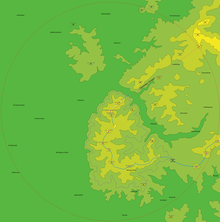
That means, within a radius of 10 km, only the southwest slope of the Hohe Berg near Huckelheim is higher than the Hahnenkamm summit (see figure on the right). The lowest closed contour line, which only surrounds the Hahnenkamm, runs 181 meters below the summit. The reference notch is located on State Road 2307 , southwest of Feldkahl at 255 m. Up to this point you have to descend from the Hahnenkamm summit at least to reach a higher mountain, the Gartenberg (493 m) near Eichenberg (see figure on the left).
Attractions
Ludwigsturm
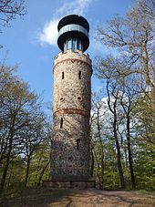
Today the 19 m high Ludwigsturm (Lage) on the summit of the mountain is the landmark of the Hahnenkamm. It was built by the Freigerichter Bund, which has been one of the oldest hiking clubs in the region since 1876, and built in 1880 under the patronage of the Bavarian King Ludwig II . The occasion was the 700th anniversary of the reign of the Wittelsbach family , which was celebrated in the same year . The stone Hahnenkamm Tower was built after almost six months of construction. On September 19, 1880 it was named Ludwigsturm in honor of King Ludwig I.
40 years earlier, he had celebrated his 54th birthday on the Hahnenkamm on August 25, 1840. With the sentence: "The Hahnenkamm leans in front of Your High Majesty" the Bavarian King was received by the crowd at the summit. The thin trees gave a perfect view of the Lower Main Valley. Even then, the chief forester of the royal forestry department warned of the rapidly growing forest that will prevent this view.
The freigericht Bund is still the owner of the structure today. In 1883 this association built a first refuge on the Hahnenkamm, in the place of which is the Hahnenkammhaus with today's excursion restaurant.
As early as 1934, the view from the platform, which was then 12 m high and accessible via 63 steps, was overgrown by the raised forest; an increase of 4 m with a further 22 steps was made. The tower is a Bavarian monument (file no. D-6-71-111-58) . In 2004 the dilapidated tower was renovated, including the modern steel tower top. The upper platform at a height of 16 m on the top of the Hahnenkamm allows a wide panoramic view in good weather:
- to the north over Geiselbach and Omersbach to the Vogelsberg with the Taufstein 50 km away (773 m),
- to the east into the Spessart ; 30 km away is the Geiersberg (586 m),
- to the south on the Main Valley , the Kahler Seenplatte , Kahl am Main , Karlstein a.Main , Seligenstadt ; further the Odenwald with the Melibokus (517.4 m) can be seen 52 km away,
- to the west on Alzenau with its districts Kälberau, Michelbach and Albstadt; on the Main you can see the Staudinger Großkrotzenburg power station . In the distance are the skyline of Frankfurt am Main and the heights of the Vordertaunus with the Großer Feldberg (879 m) 50 km away .
Summit trail
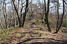
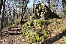
The summit path is a small footpath along the mountain ridge of the northern Hahnenkamm ridge that runs from the Ludwigsturm to the Bildeiche . The wooded slopes drop steeply to the left and right of the path. In some places quartzite rocks protrude from the ground. This area is at great risk of erosion . The path leads from the Bildeiche over the Hohe Mark and the Poisonous Berg into the Kahltal.
Picture oak
The "picture oak " is a centuries-old oak that has been designated as a natural monument . It is on the summit path of the Hahnenkamm (Lage) , directly on the boundary between Hörstein and Kälberau . The tree is completely hollowed out by multiple lightning strikes. Because of this, the oak slowly dies. In the 1970s, half of the crown was already leaf-free. Today the picture oak no longer has a treetop. There is only the main trunk with a few stumps.
Krebsbachtal
Between the main summit and the Schanzenkopf, on the right slope of the narrow Krebsbach valley, are the castle stables of the Randenburg and the Forgotten Castle . On the opposite side of the stream, at the summit of the Schanzenkopf, there is a historic ring wall .
Transmission towers

On the summit of the Hahnenkamm there are two transmission towers: a slim 63-meter-high tower made of precast concrete and a low, thick, free-standing steel lattice tower, which served as the RV department of the warning service. The Hahnenkamm station broadcasts the Radio Primavera program with 200 W ERP on 90.8 MHz and the Radio Galaxy Aschaffenburg program with 250 W ERP on 103.6 MHz. It is also a location for existing and planned DAB broadcasts.
history

In the Middle Ages , the entire forest area from Rückersbach via Hörstein to Geiselbach was called "the Hohe Mark ". The ridge south of the Kahl , known today as the Hahnenkamm , was called "Wüstebach" at the time. It was an area of 3857 acres that was shared by the four main courts Wilmundsheim (later Alzenau), Hörstein , Mömbris and Somborn as a wild ban. In 1840 the Hahnenkamm summit was redistributed between the communities of Hörstein, Wasserlos, Alzenau and Kälberau.
The name Hahnenkamm already existed in the late Middle Ages, but it did not establish itself on maps until the 19th century. It probably goes back to the fact that the shape of the mountain ridge is reminiscent of a cockscomb with its secondary peaks and protruding quartzite blocks . According to a document in the Mömbris court book from 1609 it is written:
"The Hahnenkamm started in the Gonsenbacher, move up to ahn Michelbach and Kälberau, then up to the Kaltan, to the Woschant farm, then to the Hemspach, to the Gonsenbacher again, be part of the open court"
Today only the northern part of the Hahnenkamm ridge is called the Hohe Mark. The mountain is called Hohnekoamm in the local dialect .
A series of historical boundary stones from 1810 runs over the Hahnenkamm. They separated the areas of two former states in the Rhine Confederation . On the western side was the territory of the Grand Duchy of Hesse , to which the Alzenau office in the Starkenburg province belonged. On the eastern side was the Grand Duchy of Frankfurt with the parish Mömbris in the department of Aschaffenburg . All of these boundary stones are numbered. The line runs through the valley of the Häggraben to Rückersbach , over the Rabengrundkopf and the Stempelhöhe , past Hohl and Angelsberg , to Großhemsbach . Then the border passed Kleinhemsbach and over the Daunert into the valley of the Hemsbach near Brücken . The boundary stone row continues through the area of the quarry and over the peaks of Hoher Mark and Toxiger Berg into the Kahltal to the municipal sewage treatment plant . Most of the boundary stones are still in good condition, but no longer exist in the fields and meadows or the quarry.
flora
The forest on the Hahnenkamm is divided into two separate growth areas. At the upper ridge there are mixed stands of hardwood , especially oak and beech , with some coniferous wood such as larch , spruce and pine . In the growing area towards the Main Plain there are especially pines due to the sandy soil. The forest has been used since the Middle Ages for the production of firewood by charcoal burners and pitchers . EDP-assisted measurements by the Senckenberg Institute in Biebergemünd have shown that the tree line compared to the meadow and pasture landscape in Kahlgrund has hardly changed in the following centuries. In the 19th century there was overuse. Extensive reforestation through fast growing conifers - pine, larch and spruce - had become necessary.
In the future, the proportion of deciduous trees - oak, beech - is to be increased again to 40%. The site was on the basis of the Bavarian Forest Act of 1975 by the Regional Plan Bavarian Lower Main region (December 2002) for forest reserve declared d. H. Clearing is only permitted in exceptional cases. Only as much wood should be used as will grow back in the forest; in addition, an area is only thinned approximately every ten years.
Viticulture
The following vineyards are located on the Hahnenkamm ridge (size, mountain part and location in brackets):
- Steinberg (10 ha, Heidkopf, Michelbach)
- Schloßberg (15 ha Schanzenkopf, waterless)
- Luhmännchen (6 ha, Schützberg, Wasserlos)
- Abtsberg (34 ha, Schützberg, Hörstein)
- Reuschberg (34 ha, Stutz, Hörstein)
geology
The northern ridge is mainly made up of stones containing quartz (quartzite slate, mica slate ) and is at risk of erosion due to the very thin layer of humus . This rock occurs mainly on the summit path between the Hahnenkammhaus and the picture oak. The southeastern part consists of staurolite in the paragneiss . Different materials were extracted at different points on the ridge. On the eastern Hahnenkamm ridge, below the Hohe Mark , mica-rich quartzite was exploited for decades in the Hemsbach quarry in a quarry that has now been closed. This quartz train runs parallel to that of the cockscomb. In the meantime, a mountain lake, the Hahnenkammsee , has formed on the floor of the quarry due to incoming rainwater , as the dewatering was stopped after the quarry was closed.
Geotope
The quartzite blocks on the Hahnenkamm have been designated as a valuable geotope (geotope number: 671A020) by the Bavarian State Office for the Environment . See also the list of geotopes in the Aschaffenburg district .
Others
- Streets in Kahl , Wasserlos , Dettingen , Stockstadt , Somborn , Gondsroth , Rothenbergen , Hanau , Wachenbuchen and Bergen-Enkheim are named after the Hahnenkamm heights .
- The Franconian Marienweg leads over the Hahnenkamm .
- The southern part of the Hahnenkamm Ridge, over which the state road 2443 leads from Hohl to Hörstein, is popularly known as the Hohler Alpen or Hohler Chaussee .
- The area around the Hahnenkamm is a popular destination for mountain bikers and hikers.
See also
Web links
- The Hahnenkamm, from Rückersbach in the south to the north arch of the Kahl : BayernAtlas of the Bavarian State Government ( information )
- Hahnenkamm circuit to the Ludwigsturm in the GPS hiking atlas
Individual evidence
- ↑ Map services of the Federal Agency for Nature Conservation ( information )
- ↑ Germany 2013/2014: ADAC Reise Atlas 1: 150000 © 2013 MairDumont Media, D-73751 Ostfildern (2.)
- ↑ a b Our Kahlgrund 1956 . Homeland yearbook for the Alzenau district. Published by the working group for homeland research and homeland maintenance of the Alzenau district, district administrator. ISSN 0933-1328 .
- ↑ Geography based on: BayernAtlas of the Bavarian State Government ( notes )
- ↑ Bavaria Atlas of the Bavarian State Government ( notes )
- ↑ a b Height information according to measurements carried out privately; Total height approx. 3 m above the upper platform (16 m high)
- ↑ a b c d Photo of the information board on the tower, on commons.wikimedia.org
- ↑ Our Kahlgrund 1966 . Homeland yearbook for the Alzenau district. Published by the working group for homeland research and homeland maintenance of the Alzenau district, district administrator. ISSN 0933-1328 .
- ↑ Our Kahlgrund 2013 . Homeland yearbook for the Alzenau district. Published by the working group for homeland research and homeland maintenance of the Alzenau district, district administrator. ISSN 0933-1328 .
- ↑ Sponsorship Award 2003; Object: Ludwigturm on the Hahnenkamm in Alzenau on the website of the Lower Franconia district, accessed on December 4, 2017
- ↑ Our Kahlgrund 1974 . Homeland yearbook for the Alzenau district. Published by the working group for homeland research and homeland maintenance of the Alzenau district, district administrator. ISSN 0933-1328 .
- ^ Forests and pilgrimages: Alzenau, Hahnenkamm and Kälberau
- ↑ Our Kahlgrund 1969 . Homeland yearbook for the Alzenau district. Published by the working group for homeland research and homeland maintenance of the Alzenau district, district administrator. ISSN 0933-1328 .
- ^ Forest Act for Bavaria (BayWaldG)
- ↑ Our Kahlgrund 1984 . Homeland yearbook for the Alzenau district. Published by the working group for homeland research and homeland maintenance of the Alzenau district, district administrator. ISSN 0933-1328 .
- ^ Bavarian State Office for the Environment, Geotop quartzite blocks at Hahnenkamm SE from Kälberau (accessed on March 22, 2020).


