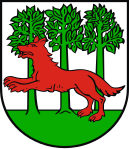
Międzylesie
| Międzylesie | ||
|---|---|---|

|
|
|
| Basic data | ||
| State : | Poland | |
| Voivodeship : | Lower Silesia | |
| Powiat : | Kłodzko | |
| Area : | 14.45 km² | |
| Geographic location : | 50 ° 10 ′ N , 16 ° 40 ′ E | |
| Height : | 435-470 m npm | |
| Residents : | 2575 (June 30, 2019) |
|
| Postal code : | 57-530 | |
| Telephone code : | (+48) 74 | |
| Economy and Transport | ||
| Rail route : |
Railway line Wrocław – Międzylesie Chlumec nad Cidlinou – Międzylesie |
|
| Gmina | ||
| Gminatype: | Urban and rural municipality | |
| Surface: | 189.00 km² | |
| Residents: | 7186 (June 30, 2019) |
|
| Population density : | 38 inhabitants / km² | |
| Community number ( GUS ): | 0208103 | |
| Administration (as of 2015) | ||
| Mayor : | Tomasz Korczak | |
| Address: | pl. Wolności 1 57-530 Międzylesie |
|
| Website : | www.miedzylesie.pl | |
Międzylesie (German Mittelwalde ) is a town in the powiat Kłodzki in the Lower Silesian Voivodeship in Poland. It is the seat of the urban and rural community of the same name. Historically, Mittelwalde belonged to the former County of Glatz .
geography

The city is located in the south of the Glatzer Kessel in the valley of the Glatzer Neisse between the Habelschwerdter Mountains and the Glatzer Schneegebirge at 429 m above sea level. NHN , about 32 km south of Kłodzko ( Glatz ). To the west lies the 713 m high Bochniak ( salt dome ). The border with the Czech Republic runs not far to the east, south and west . The southern border crossing Boboszów ( Boboschau ) / Dolní Lipka ( Niederlipka ) is seven kilometers south.
Neighboring towns are Nagodzice ( Herzogswalde ) and Roztoki ( Schönfeld ) in the north, Michałowice ( Michaelsthal ) and Goworów ( Lauterbach ) in the northeast, Szklarnia ( Gläsendorf ) and Dolnik ( Schönthal ) in the east, Smreczyna ( Schönau b. Mittelwalde ) and Kamieńczyk ( Steinbach ) in the south.
history
As a sovereign chamber property , Mittelwalde belonged to the Bohemian king together with the Glatzer Land , with which it shared the history of its political and ecclesiastical affiliation . Under Duke Břetislav I , a fortified castle is said to have been built here to secure the important trade route from Wroclaw via Glatz to Brno and Vienna . As a city Mittelwalde is first documented in 1294, when she Czech King Wenceslas II. , Together with the rule Mittelwalde the Cistercian Abbey Kamenz gave to the edition, does not separate the city "for all time" of the Bohemian crown, while continuing Bohemian fief remained . As early as 1315, however, it came to Otto von Glaubitz - together with the lords of Karpenstein and Schnallenstein - who bequeathed it to his son Otto in 1381, who was nicknamed “Schramme”. He was followed in 1420 by Wolfhard von Glaubitz. In the Hussite Wars , the city was destroyed by the Taborites in 1428 and therefore returned to the lordly chamber, so that it was administered by burgraves.
After the death of the Bohemian King Georg von Podiebrad , after the division of the estate in 1472, his son Duke Heinrich d. Ä. from Münsterberg the county of Glatz. In the same year he gave the town of Mittelwalde with the villages of Herzogswalde, Schönwald, Jaworek, Nowuwes, Heynau, Lauterbach, Sklenarzwicze, Schönthal and Bobischau as a fief to Balthasar Zischwitz on Wölfelsdorf . Already on May 21, 1469 he had sold Mittelwalde to Georg von Bischofstein ( Jiřík z Bišofsteinu ), called "Latovský". Heinrich's wife Ursula von Brandenburg († 1508) had to agree to the sale , as Mittelwalde was part of her marriage property that had been granted to her by her father-in-law Georg von Podiebrad. In 1493, Mittelwalde and the associated estate were acquired by Johann Bartosowsky von Laboun ( Jan Bartošovský z Labouně ), from whom it was acquired with the permission of Heinrich the Elder . Ä. 1495 Johann von Žampach and Pottenstein acquired. Wenzel von Žampach and Pottenstein pledged the Mittelwalde estate with the associated villages in 1538 to Johann von Tschirnhaus on Bolkenhain , to whom he sold it in 1549. In 1551 it belonged to David von Tschirnhaus, from whom his sons David and Michael inherited it in 1564. Since David died in 1600 with no descendants, his share fell to his brother Michael, who had owned the Wölfelsdorf estate since 1597.
After the death of Michael von Tschirnhaus in 1607, his sons Friedrich, Hans and David Heinrich were raised to the baron status and the previous fiefs of Mittelwalde and Wölfelsdorf were inherited in 1608 . Emperor Rudolf II granted the city two annual markets and a weekly market and granted the landlords the right to use a coat of arms. After the division of the estate, David Heinrich got the Mittelwalde estate with Bobischau, Schreibendorf, Schönthal, Schönau, Grenzendorf and Herzogswalde. He later also acquired the Wölfelsdorf estate and illegally acquired the Schönfeld estate in 1618 . As a participant in the Bohemian class uprising , he was a supporter of the winter king Friedrich von der Pfalz , who appointed him governor of the county of Glatz on May 12, 1620 . After the conquest of the Glatzer country by the imperial troops of Ferdinand II , he was removed from office and had to return the Schönfeld estate to Johann Arbogast von Annenberg . His other possessions were confiscated by the emperor.
During the Thirty Years' War, the population of Mittelwalde suffered heavy looting in 1622. On July 6, 1643, Swedish horsemen burned the city down. The two churches and the rectory as well as the school were also destroyed. In 1633 379 people died of the plague.
From 1624 to 1626 Mittelwalde was owned by the Governor of Glatzer, Rudolf Philipp von Liechtenstein-Kastelkorn, and then fell back to the Bohemian King as chamber property. As such, it was administered until 1632 by Martin Mühlanger von Mühlau and 1633–1638 Georg von Kronenberg on Oberschwedeldorf , who held the office of captain. In 1637 David Heinrich von Tschirnhaus succeeded in redeeming his goods in the county of Glatz. After his death in 1652, his widow Maria Hedwig von Dohna to Lieberose and her co-heirs sold the dominions Mittelwalde and Wölfelsdorf in 1653 to Count Michael Ferdinand von Althann († 1658), who already owned the nearby dominions Grulich and Wichstadtl in Bohemia. This introduced regulated legal and property relations and converted his possessions to a majorate . His son and heir Michael Franz von Althann († 1676) rebuilt the parish church and St. Barbara chapel and promoted religious life. Since he died without heirs, his uncle Michael Wenzel von Althann inherited the property . He expanded his property in 1684 by buying numerous chamber villages in the Habelschwerdt district , from which he formed the Schnallenstein rule and several villages in the Landeck district , which he combined to form the Seitenberg rule . In the Mittelwalde he built a two-winged baroque building around 1684, which was attached to the renaissance castle , which was rebuilt around 1580 . His son of the same name had the statue of Mary erected on the ring in 1698.
Together with the County of Glatz, Mittelwalde fell to Prussia after the First Silesian War in 1742 and finally after the Peace of Hubertusburg in 1763 . With the flourishing linen industry and flax cultivation, Mittelwalde experienced an economic boom from 1750 onwards. In the coalition wars, the rulers were again subjected to drastic war burdens. At the same time the overseas linen trade came to a standstill due to the Napoleonic continental barrier. The world-famous Mittelwald screen company Ludwig had to file for bankruptcy, so that economic development stagnated. Mittelwalde was unable to regain its connection with its former world trading partners. It was only with the commissioning of the Breslau – Mittelwalde railway line in 1875, which enabled a connection to Prague and Vienna, and the settlement of industrial companies, that new sales markets could be opened up. At the beginning of the 20th century, Mittelwalde had one Protestant and two Catholic churches, a Prussian and an Austrian main customs office, and was the seat of a local court .
With the introduction of the Prussian town order in 1809, Mittelwalde became an independent municipality, after subordination to the estate had been abolished in 1807. After the reorganization of Prussia, it belonged to the province of Silesia from 1815 and was incorporated into the district of Habelschwerdt from 1818–1945 , with which it was connected until 1945. The property remained in the possession of the von Althann family until it was expropriated in 1945.
Towards the end of the Second World War , Mittelwalde was occupied by the Red Army in the spring of 1945 and, like almost all of Silesia, was placed under Polish administration by the Soviet Union after the end of the war . The German city has now been renamed Międzylesie . Subsequently, the immigration of Polish migrants began, some of whom came from areas east of the Curzon Line that had fallen to the Soviet Union and where they had belonged to the Polish minority. In the period that followed, the local German population was expelled by the local Polish administrative authority .
Demographics
| year | Residents | Remarks |
|---|---|---|
| 1788 | 1356 | |
| 1803 | 1220 | |
| 1810 | 1456 | |
| 1816 | 1322 | without Vorwerk Mittelwalde and Dreihöfe with 80 inhabitants; According to other information, 1,340 inhabitants, including twelve Evangelicals and 1328 Catholics (no Jews) |
| 1821 | 1232 | |
| 1825 | 1519 | including 46 Evangelicals |
| 1840 | 1763 | including 51 Evangelicals and 1712 Catholics |
| 1852 | 1819 | |
| 1867 | 2134 | on December 3rd, excluding the castle with 121 inhabitants |
| 1871 | 2152 | According to other data, 2151 inhabitants (on December 1), of which 87 are Protestants, 2060 Catholics, four Jews, excluding the castle with 103 inhabitants (102 Catholics and one Protestant person) |
| 1890 | 2808 | including 270 Evangelicals and eight Jews |
| 1905 | 2931 | mostly Catholic residents |
| 1910 | 2805 | without the manor district with 119 inhabitants |
| 1933 | 2627 | |
| 1939 | 2589 |
Sponsorship for the displaced
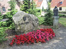
A large part of the expelled city dwellers came to Lohne (Oldenburg) , which in 1952 took over the sponsorship of the expellees from Mittelwalde at the instigation of councilor Joseph Andreas Pausewang, who came from Mittelwalde. The “Mittelwalder Stone” and the bronze sculpture “Mantle Madonna” by Judith von Eßen were erected in the Mühlenkamp settlement in Lohn to commemorate the fate of the German Mittelwalder . A "Mittelwalder Heimatstube" is located in the basement of the Lohner town hall. The sponsorship of Lohne for Mittelwalde was further developed in 2010 to a town partnership between Lohne and Międzylesie.
Attractions
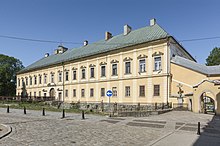
- The Castle Mittelwalde was built to replace the destroyed during the Hussite Wars Castle 1580-1590 by Michael von Tschirnhaus in the Renaissance style with sgraffito decorated. The Counts Althann had it extended by a two-wing baroque building from 1684–1686 according to plans by the fortress builder Jakob Carove. Inside is a masterfully designed staircase. The Renaissance portal in the courtyard is decorated with sixteen coats of arms. In the upper row there are eight coats of arms of the parents, grandparents and those of the great-grandparents of the locksmith builder Michael von Tschirnhaus, in the lower row eight coats of arms of the ancestors of his wife Anna von Reinsberg. The portal, carefully carved by stonemasons, is adorned with the symbols of justice ( sword and scales ) and faith ( cross and chalice ). In 1778 the castle was connected to the parish church by a two-story corridor. At the end of the 17th century, a terraced ornamental garden was laid out in the west of the castle, which was adorned with allegorical sculptures and vases from the beginning of the 18th century. The castle is in a poor structural condition and is not accessible.
- The parish church of Corpus Christi ( Kościół Bożego Ciała ) was first mentioned in 1384. It was rebuilt in 1676 and 1712–1713. The architectural side altars of St. Joseph and St. Mary as well as the sculptures of St. Johannes Nepomuk, Eligius, Johannes Evangelist and John the Baptist as well as the organ prospectus . The ship-shaped reliefs of the pulpit depict the following biblical scenes: Christophorus carries the baby Jesus , Augustine speaks to the boy who wants to scoop out the sea , Francis of Assisi preaches to the fish and Jonas and the fish that is thrown into the sea . The church tower was built in 1699 according to plans by Jacob Carove.
- The branch church of St. Barbara ( Kościół Św. Barbary ) is a former burial church, which was built in 1617 in the late Renaissance style and rebuilt after the destruction in 1643 in the years 1670–1671. The main altar was created in 1831 by J. Schramm, the figures of St. Barbara and St. Catherine by A. Nitsch in 1741. The side altar of Mary with the figures of Saint Francis Xavier and Saint Ignatius is from the 2nd half of the 18th century. In the church there is also the tomb of the canvas manufacturer Ludwig with alabaster portraits on a black obelisk . On the outside of the church there are epitaphs from the Renaissance period.
- The Marian column on the ring was donated by Michael Wenzel von Althann in 1698. On the Corinthian capital there is the Madonna and Child , the base is decorated with the figures of St. Wenzel , Benedikt , Hubertus and Michael .
- The Trinity Column on the road to Boboszów dates from 1719.
- The cloth halls with a gable roof and arched arbors on pillar arcades ( on the southern arterial road ), built around 1740 from a foundation by the canvas manufacturer Ludwig, were left to decay after the Second World War. Four of the original 14 axles are still preserved.
local community
The municipality covers an area of 174 km² with 8,150 inhabitants. This corresponds to a population density of 43.12 people / km². The localities belong to it:
Boboszów ( Bobischau ) Czerwony Strumień ( Rothflössel ) Długopole Górne (upper Langenau) Dolnik ( Schonenthal ) Domaszków ( Ebersdorf ) Gajnik ( Hain ) Gniewoszów ( Seitendorf ) Goworów ( Lauterbach ), Jaworek ( Urnitz ) Jodłów ( Thandorf ), Kamieńczyk ( Steinbach ), Lesica ( Freiwalde ), Michałowice ( Michaelsthal ), Nagodzice ( Herzogswalde ), Niemojów ( Marienthal ), Nowa Wieś ( Neundorf ), Pisary ( Schreibendorf ), Potoczek ( Neißbach ), Różanka ( Rosenthal ), Roztoki ( Schönfeld ), Smreczyna ( Schönau ) and Szklarnia ( Gläsendorf ) as well as the area of the no longer existing village of Czerwony Strumień ( Rothflössel ).
Twin cities
- Králíky , Czech Republic
- Lohne (Oldenburg) , Germany
Personalities
- Franz Dittert (1857–1937), pastor of Mittelwalde as well as grand dean and vicar of the County of Glatz
- Emil Sandt (1864–1938), customs officer and writer
- Franz Xaver Monse (1882–1962) Pastor of Glatz and Grand Dean and Vicar of the County of Glatz
- Edwin Dutton (1890–1972), German-British soccer player
- Hans Ramshorn (1892–1934), officer and politician (NSDAP)
- Paul Heimann (1901–1967), German educationalist
literature
- Johann Georg Knie : Alphabetical-statistical-topographical overview of the villages, towns, cities and other places of the royal family. Preusz. Province of Silesia . 2nd edition, Breslau 1845, pp. 873-874.
- Friedrich Gottlob Leonhardi : Earth Description of the Prussian Monarchy , Volume 3, Part 1, Halle 1792, pp. 225-226 .
- Karl August Müller: Patriotic images, or history and description of all castles and knight palaces in Silesia and the county of Glatz. Second edition, Glogau 1844, pp. 121–126.
- Dehio Handbook of Art Monuments in Poland. Silesia. Deutscher Kunstverlag, Munich et al. 2005, ISBN 3-422-03109-X , pp. 613–614.
- Joseph Kögler : The chronicles of the county Glatz. Revised and edited by Dieter Pohl . Volume 1: The town and parish chronicles of Lewin - Mittelwalde - Wünschelburg - Neurode - Wilhelmsthal. Pohl, Modautal 1993, ISBN 3-927830-06-2 , pp. 80-89 ( historical sources of the county of Glatz. Series A: Ortsgeschichte NF 1).
- Hugo Weczerka (Hrsg.): Handbook of the historical places . Volume: Silesia (= Kröner's pocket edition . Volume 316). Kröner, Stuttgart 1977, ISBN 3-520-31601-3 , pp. 317-318.
- Benno Dräger: Lohne - Mittelwalde / Miedzylesie: 50 years of sponsorship . In: Laon - Lohne 2002 (Ed .: Heimatverein Lohne). Lohne 2002, pp. 134-140.
Web links
- City and municipality website
- City of Mittelwalde (Schles.) - Territorial (Rolf Jehke, 2002)
- Historical and current views
- Historical and current recordings of the castle
- railway station
- Weber houses
- Historical views
- District 1908
Individual evidence
- ↑ a b population. Size and Structure by Territorial Division. As of June 30, 2019. Główny Urząd Statystyczny (GUS) (PDF files; 0.99 MiB), accessed December 24, 2019 .
- ^ Website of the municipality (BIP), Burmistrz Miasta i Gminy , accessed on February 26, 2015
- ↑ a b c Meyer's Large Conversation Lexicon . 6th edition, Volume 13, Leipzig and Vienna 1908, p. 825.
- ↑ Martin Šandera: Jindřich I. Minsterberkský - První Hrabě Kladský a jeho majetková základna . In: Kladský sborník 6, 2004, p. 15
- ^ Friedrich Gottlob Leonhardi : Description of the Earth of the Prussian Monarchy , Volume 3, Part 1, Halle 1792, pp. 225-226 .
- ↑ a b c d Alexander August Mützell and Leopold Krug : New topographical-statistical-geographical dictionary of the Prussian state . Volume 5: T – Z , Halle 1823, pp. 336–339, item 443.
- ↑ Alexander August Mützell and Leopold Krug : New topographical-statistical-geographical dictionary of the Prussian state . Volume 3: Kr – O , Halle 1822, p. 206, numbers 2032-2033.
- ^ Johann Georg Knie : Alphabetical-statistical-topographical overview of the villages, spots, towns and other places of the royal family. Prussia. Province of Silesia, including the Margraviate of Upper Lusatia, which now belongs entirely to the province, and the County of Glatz; together with the attached evidence of the division of the country into the various branches of civil administration . Breslau 1830, p. 970.
- ^ Johann Georg Knie : Alphabetical-statistical-topographical overview of the villages, spots, cities and other places of the royal family. Preusz. Province of Silesia . 2nd edition, Breslau 1845, pp. 873-874.
- ^ Kraatz: Topographical-statistical manual of the Prussian state . Berlin 1856, p. 396.
- ^ A b Royal Statistical Bureau: The municipalities and manor districts of the province of Silesia and their population. Based on the original materials of the general census of December 1, 1871. Berlin 1874, pp. 156–157, item 3 .
- ^ A b Royal Statistical Bureau: The municipalities and manor districts of the province of Silesia and their population. Based on the original materials of the general census of December 1, 1871. Berlin 1874, pp. 160–161, item 110 .
- ^ Gustav Neumann : Geography of the Prussian State . 2nd edition, Volume 2, Berlin 1874, p. 210, item 24 .;
- ^ A b c Michael Rademacher: German administrative history from the unification of the empire in 1871 to the reunification in 1990. habelschwerdt.html # ew39hablhabelsc. (Online material for the dissertation, Osnabrück 2006).
- ↑ gemeindeververzeichnis.de
- ^ Parish of St. Gertrud Lohne (ed.): Wegzeichen - Glaubenszeichen. In the parish of St. Gertrud Lohne . Rewards. 2011, p. 178f. ( online. pdf ( Memento of the original from March 4, 2016 in the Internet Archive ) Info: The archive link has been inserted automatically and has not yet been checked. Please check the original and archive link according to the instructions and then remove this note. )
- ^ Federal Institute for Culture and History of Germans in Eastern Europe (BKGE): Heimatstube Mittelwalde


