Negrepelisse
| Negrepelisse | ||
|---|---|---|

|
|
|
| region | Occitania | |
| Department | Tarn-et-Garonne | |
| Arrondissement | Montauban | |
| Canton | Aveyron-Lère | |
| Community association | Quercy Vert-Aveyron | |
| Coordinates | 44 ° 5 ' N , 1 ° 31' E | |
| height | 79-207 m | |
| surface | 49.22 km 2 | |
| Residents | 5,628 (January 1, 2017) | |
| Population density | 114 inhabitants / km 2 | |
| Post Code | 82800 | |
| INSEE code | 82134 | |
| Website | http://www.ville-negrepelisse.fr/ | |
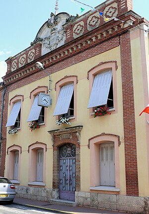
 Town hall of Nègrepelisse |
||
Nègrepelisse is a French commune with 5628 inhabitants (as of January 1, 2017) in the Tarn-et-Garonne department in the Occitanie region . It is the administrative seat of the canton of Aveyron-Lère and is located in the arrondissement of Montauban .
geography
The city is located on the southern bank of the Aveyron River about 15 kilometers northeast of Montauban .
history
The Château de Nègrepelisse was finished under construction in 1074. The Bastide Nègrepelisse, latinized Nigra Pelliciacum , was founded in the late 13th century. In 1285 Philip III. the founding act. The place hosted Calvinists early on . From June 10th to 11th, 1622, the battle or the massacre of Nègrepelisse took place here when King Louis XIII 800 city dwellers, Huguenots , the entire male city population, executed.
Attractions
- Château de Nègrepelisse
- Saint-Pierre-ès-Liens church
- Temple de Nègrepelisse
- Moulin de Nègrepelisse
Personalities
- Jean I Barraband (* around 1650 in Nègrepelisse, † 1709, Berlin ) was a Huguenot religious refugee who worked as a picture maker in Berlin .
- Eugène Aujaleu (1903–1990), medic
- André Jouany (1928–1984), politician, senator for the province of Tarn-et-Garonne
