Campsas
|
Campsas Campsàs |
||
|---|---|---|

|
|
|
| region | Occitania | |
| Department | Tarn-et-Garonne | |
| Arrondissement | Montauban | |
| Canton | Verdun-sur-Garonne | |
| Community association | Grand Sud Tarn et Garonne | |
| Coordinates | 43 ° 54 ' N , 1 ° 20' E | |
| height | 104-144 m | |
| surface | 15.01 km 2 | |
| Residents | 1,368 (January 1, 2017) | |
| Population density | 91 inhabitants / km 2 | |
| Post Code | 82370 | |
| INSEE code | 82027 | |
| Website | www.campsas.fr | |
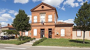
 City Hall ( Mairie ) of Campsas |
||
Campsas ( Occitan : Campsàs ) is a French commune with 1,368 inhabitants (as of January 1, 2017) in the Tarn-et-Garonne department in the Occitania region (before 2016: Midi-Pyrénées ). It belongs to the arrondissement of Montauban and is part of the canton Verdun-sur-Garonne (until 2015: canton Grisolles ). The inhabitants are called Campsanais .
geography
Campsas is located about 13 kilometers south-southwest of Montauban and about 33 kilometers north-northwest of Toulouse . Campsas is surrounded by the neighboring communities of Labastide-Saint-Pierre in the north, Orgeuil in the east, Fronton in the southeast, Fabas in the south, Canals and Dieupentale in the southwest, Bessens in the west and Montbartier in the northwest.
The A62 autoroute and the former Route nationale 20 (today's D820) run through the municipality .
| year | 1962 | 1968 | 1975 | 1982 | 1990 | 1999 | 2006 | 2017 |
|---|---|---|---|---|---|---|---|---|
| Residents | 554 | 485 | 495 | 559 | 636 | 870 | 1,032 | 1,368 |
Attractions
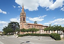
- Saint-Blaise church from the 19th century

